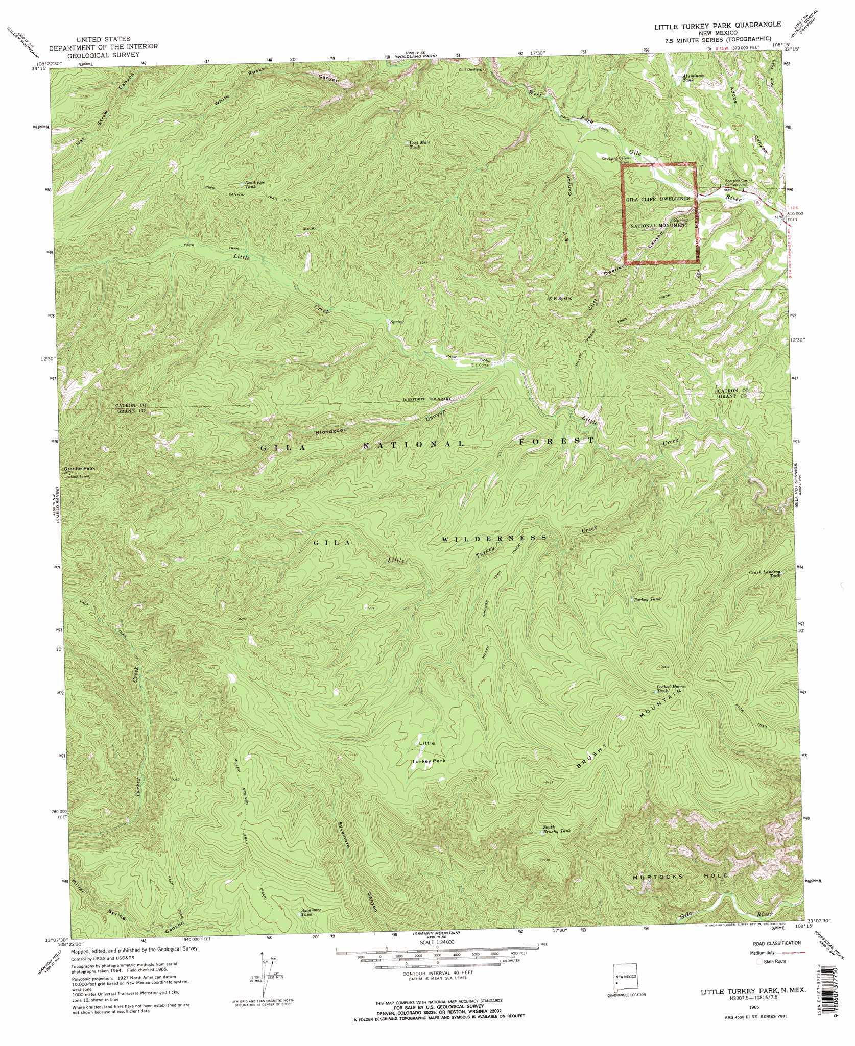
Little Turkey Park Topo Map New Mexico
To zoom in, hover over the map of Little Turkey Park
USGS Topo Quad 33108b3 - 1:24,000 scale
| Topo Map Name: | Little Turkey Park |
| USGS Topo Quad ID: | 33108b3 |
| Print Size: | ca. 21 1/4" wide x 27" high |
| Southeast Coordinates: | 33.125° N latitude / 108.25° W longitude |
| Map Center Coordinates: | 33.1875° N latitude / 108.3125° W longitude |
| U.S. State: | NM |
| Filename: | o33108b3.jpg |
| Download Map JPG Image: | Little Turkey Park topo map 1:24,000 scale |
| Map Type: | Topographic |
| Topo Series: | 7.5´ |
| Map Scale: | 1:24,000 |
| Source of Map Images: | United States Geological Survey (USGS) |
| Alternate Map Versions: |
Little Turkey Park NM 1965, updated 1970 Download PDF Buy paper map Little Turkey Park NM 1999, updated 2002 Download PDF Buy paper map Little Turkey Park NM 2011 Download PDF Buy paper map Little Turkey Park NM 2013 Download PDF Buy paper map Little Turkey Park NM 2017 Download PDF Buy paper map |
| FStopo: | US Forest Service topo Little Turkey Park is available: Download FStopo PDF Download FStopo TIF |
1:24,000 Topo Quads surrounding Little Turkey Park
Negrito Mountain |
Loco Mountain |
Canyon Creek Mountains |
Black Mountain |
Spring Canyon |
Mogollon Baldy Peak |
Lilley Mountain |
Woodland Park |
Burnt Corral Canyon |
Wall Lake |
Shelley Peak |
Diablo Range |
Little Turkey Park |
Gila Hot Springs |
Middle Mesa |
Canteen Canyon |
Canyon Hill |
Granny Mountain |
Copperas Peak |
North Star Mesa |
Cliff |
Dorsey Ranch |
Reading Mountain |
Twin Sisters |
Allie Canyon |
> Back to 33108a1 at 1:100,000 scale
> Back to 33108a1 at 1:250,000 scale
> Back to U.S. Topo Maps home
Little Turkey Park topo map: Gazetteer
Little Turkey Park: Basins
Murtocks Hole elevation 1640m 5380′Little Turkey Park: Flats
Little Turkey Pack elevation 2250m 7381′Little Turkey Park: Parks
Gila Cliff Dwellings National Monument elevation 1852m 6076′Little Turkey Park: Reservoirs
Aluminum Tank elevation 1840m 6036′Crash Landing Tank elevation 2008m 6587′
Dead Eye Tank elevation 2122m 6961′
Locked Horns Tank elevation 2337m 7667′
Lost Mule Tank elevation 2005m 6578′
South Brushy Tank elevation 2219m 7280′
Sycamore Tank elevation 2158m 7080′
Turkey Tank elevation 2201m 7221′
Little Turkey Park: Springs
E E Spring elevation 1951m 6400′Little Turkey Park: Streams
Little Turkey Creek elevation 1892m 6207′Little Turkey Park: Summits
Brushy Mountain elevation 2480m 8136′Granite Peak elevation 2656m 8713′
Little Turkey Park: Trails
Brushy Mountain Trail elevation 2326m 7631′Miller Springs Trail elevation 2226m 7303′
Ring Canyon Trail elevation 2177m 7142′
Little Turkey Park: Valleys
Adobe Canyon elevation 1727m 5666′Bloodgood Canyon elevation 1959m 6427′
Cliff Dweller Canyon elevation 1736m 5695′
E E Canyon elevation 1755m 5757′
White Rocks Canyon elevation 1805m 5921′
Little Turkey Park: Wells
GSF-2277 Water Well elevation 1844m 6049′GSF-2278 Water Well elevation 1845m 6053′
GSF-2279 1 Water Well elevation 1843m 6046′
GSF-2343 Water Well elevation 1843m 6046′
Little Turkey Park digital topo map on disk
Buy this Little Turkey Park topo map showing relief, roads, GPS coordinates and other geographical features, as a high-resolution digital map file on DVD: