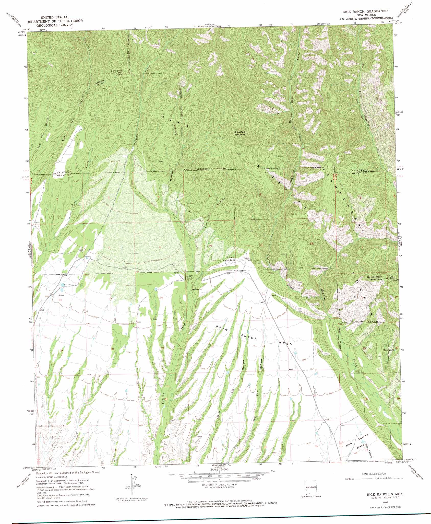
Rice Ranch Topo Map New Mexico
To zoom in, hover over the map of Rice Ranch
USGS Topo Quad 33108b6 - 1:24,000 scale
| Topo Map Name: | Rice Ranch |
| USGS Topo Quad ID: | 33108b6 |
| Print Size: | ca. 21 1/4" wide x 27" high |
| Southeast Coordinates: | 33.125° N latitude / 108.625° W longitude |
| Map Center Coordinates: | 33.1875° N latitude / 108.6875° W longitude |
| U.S. State: | NM |
| Filename: | o33108b6.jpg |
| Download Map JPG Image: | Rice Ranch topo map 1:24,000 scale |
| Map Type: | Topographic |
| Topo Series: | 7.5´ |
| Map Scale: | 1:24,000 |
| Source of Map Images: | United States Geological Survey (USGS) |
| Alternate Map Versions: |
Rice Ranch NM 1965, updated 1969 Download PDF Buy paper map Rice Ranch NM 1999, updated 2002 Download PDF Buy paper map Rice Ranch NM 2011 Download PDF Buy paper map Rice Ranch NM 2013 Download PDF Buy paper map Rice Ranch NM 2017 Download PDF Buy paper map |
| FStopo: | US Forest Service topo Rice Ranch is available: Download FStopo PDF Download FStopo TIF |
1:24,000 Topo Quads surrounding Rice Ranch
Alma |
Mogollon |
Bearwallow Mountain |
Negrito Mountain |
Loco Mountain |
Glenwood |
Holt Mountain |
Grouse Mountain |
Mogollon Baldy Peak |
Lilley Mountain |
Wilson Mountain |
Moon Ranch |
Rice Ranch |
Shelley Peak |
Diablo Range |
Mule Creek |
Bear Mountain |
Buckhorn |
Canteen Canyon |
Canyon Hill |
Crookson Peak |
Applegate Mountain |
Antelope Ridge |
Cliff |
Dorsey Ranch |
> Back to 33108a1 at 1:100,000 scale
> Back to 33108a1 at 1:250,000 scale
> Back to U.S. Topo Maps home
Rice Ranch topo map: Gazetteer
Rice Ranch: Airports
Sacaton Landing Strip elevation 1860m 6102′Rice Ranch: Benches
Rain Creek Mesa elevation 1807m 5928′Rice Ranch: Mines
Alexander Mine elevation 2372m 7782′Blue Rock Prospect elevation 2175m 7135′
Copper Glance Shaft elevation 1979m 6492′
Fairview Mine and Vicinity elevation 2802m 9192′
Goodhope Adit elevation 2054m 6738′
Haystack Mountain Area Working elevation 2239m 7345′
Hightower Prospect elevation 2175m 7135′
Lone Pine Mine elevation 2189m 7181′
Lower Little Dry Creek Working elevation 2155m 7070′
Point of Rock Prospect elevation 2605m 8546′
Prospect Hightower, Junior elevation 1951m 6400′
Rainbow Prospect elevation 1715m 5626′
Reward Prospect elevation 2134m 7001′
Sacaton Mine elevation 2175m 7135′
Yellow Peril Adit elevation 2136m 7007′
Rice Ranch: Reservoirs
Pipe Tank elevation 1820m 5971′Pipeline Tank elevation 1868m 6128′
Sacaton South Tank elevation 1827m 5994′
Trail Tank elevation 1866m 6122′
West Tank elevation 1758m 5767′
Rice Ranch: Springs
Little Dry Spring elevation 1959m 6427′White Rocks Spring elevation 2132m 6994′
Rice Ranch: Streams
Rain Creek elevation 1660m 5446′Rice Ranch: Summits
Haystack Mountain elevation 2545m 8349′Lone Pine Hill elevation 2295m 7529′
Seventyfour Mountain elevation 2353m 7719′
Rice Ranch: Valleys
Cherry Canyon elevation 1804m 5918′Minton Canyon elevation 1839m 6033′
Mogollon Canyon elevation 1663m 5456′
Whiteside Canyon elevation 1968m 6456′
Rice Ranch digital topo map on disk
Buy this Rice Ranch topo map showing relief, roads, GPS coordinates and other geographical features, as a high-resolution digital map file on DVD: