Lilley Mountain Topo Map New Mexico
To zoom in, hover over the map of Lilley Mountain
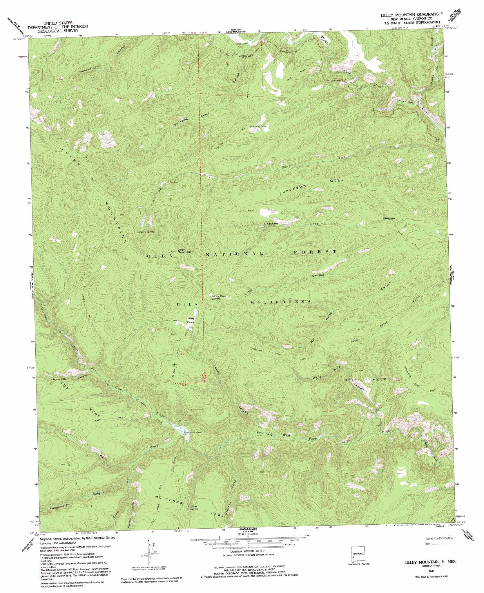
USGS Topo Quad 33108c4 - 1:24,000 scale
| Topo Map Name: | Lilley Mountain |
| USGS Topo Quad ID: | 33108c4 |
| Print Size: | ca. 21 1/4" wide x 27" high |
| Southeast Coordinates: | 33.25° N latitude / 108.375° W longitude |
| Map Center Coordinates: | 33.3125° N latitude / 108.4375° W longitude |
| U.S. State: | NM |
| Filename: | o33108c4.jpg |
| Download Map JPG Image: | Lilley Mountain topo map 1:24,000 scale |
| Map Type: | Topographic |
| Topo Series: | 7.5´ |
| Map Scale: | 1:24,000 |
| Source of Map Images: | United States Geological Survey (USGS) |
| Alternate Map Versions: |
Lilley Mountain NM 1965, updated 1969 Download PDF Buy paper map Lilley Mountain NM 1965, updated 1992 Download PDF Buy paper map Lilley Mountain NM 1999, updated 2002 Download PDF Buy paper map Lilley Mountain NM 2011 Download PDF Buy paper map Lilley Mountain NM 2013 Download PDF Buy paper map Lilley Mountain NM 2017 Download PDF Buy paper map |
| FStopo: | US Forest Service topo Lilley Mountain is available: Download FStopo PDF Download FStopo TIF |
1:24,000 Topo Quads surrounding Lilley Mountain
Sign Camp Mountain |
Telephone Canyon |
Pitchfork Canyon |
O Bar O Canyon West |
O Bar O Canyon East |
Bearwallow Mountain |
Negrito Mountain |
Loco Mountain |
Canyon Creek Mountains |
Black Mountain |
Grouse Mountain |
Mogollon Baldy Peak |
Lilley Mountain |
Woodland Park |
Burnt Corral Canyon |
Rice Ranch |
Shelley Peak |
Diablo Range |
Little Turkey Park |
Gila Hot Springs |
Buckhorn |
Canteen Canyon |
Canyon Hill |
Granny Mountain |
Copperas Peak |
> Back to 33108a1 at 1:100,000 scale
> Back to 33108a1 at 1:250,000 scale
> Back to U.S. Topo Maps home
Lilley Mountain topo map: Gazetteer
Lilley Mountain: Areas
Hells Hole elevation 2126m 6975′Lilley Mountain: Flats
Lilley Park elevation 2387m 7831′Pine Flat elevation 2004m 6574′
Lilley Mountain: Forests
Gila National Forest elevation 2157m 7076′Lilley Mountain: Ranges
Jerky Mountains elevation 2611m 8566′Lilley Mountain: Ridges
Jackson Mesa elevation 2298m 7539′Lilley Mountain: Springs
Horse Spring elevation 2251m 7385′Lilley Park Spring elevation 2364m 7755′
Lower Marrs Spring elevation 2292m 7519′
Marrs Spring elevation 2415m 7923′
Quentin Spring elevation 2443m 8015′
Upper Marrs Spring elevation 2434m 7985′
Lilley Mountain: Streams
Canyon Creek elevation 2044m 6706′Clear Creek elevation 2024m 6640′
Hells Hole elevation 1953m 6407′
McKenna Creek elevation 2024m 6640′
Rawmeat Creek elevation 2185m 7168′
Trail Creek elevation 2130m 6988′
White Creek elevation 2091m 6860′
Lilley Mountain: Summits
Lilley Mountain elevation 2725m 8940′Lilley Mountain: Trails
Trotter Trail elevation 2400m 7874′Lilley Mountain: Valleys
Flying V Canyon elevation 2093m 6866′Hells Hole Canyon elevation 1953m 6407′
Langstroth Canyon elevation 2156m 7073′
Lilley Canyon elevation 2120m 6955′
Lilley Canyon elevation 2003m 6571′
No Name Canyon elevation 2108m 6916′
Packsaddle Canyon elevation 2154m 7066′
Swinging Cross Canyon elevation 2103m 6899′
Lilley Mountain digital topo map on disk
Buy this Lilley Mountain topo map showing relief, roads, GPS coordinates and other geographical features, as a high-resolution digital map file on DVD: