Negrito Mountain Topo Map New Mexico
To zoom in, hover over the map of Negrito Mountain
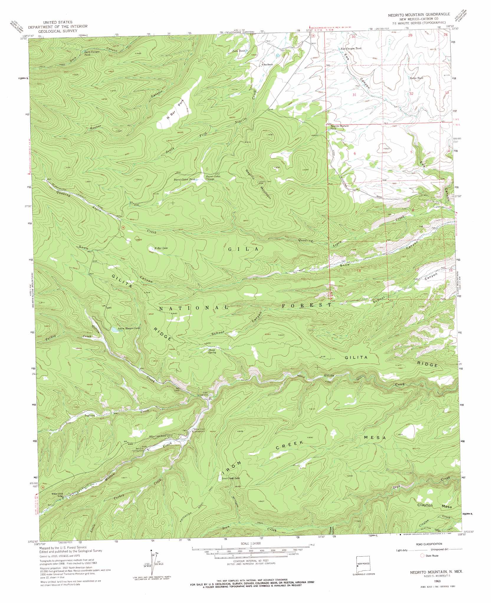
USGS Topo Quad 33108d5 - 1:24,000 scale
| Topo Map Name: | Negrito Mountain |
| USGS Topo Quad ID: | 33108d5 |
| Print Size: | ca. 21 1/4" wide x 27" high |
| Southeast Coordinates: | 33.375° N latitude / 108.5° W longitude |
| Map Center Coordinates: | 33.4375° N latitude / 108.5625° W longitude |
| U.S. State: | NM |
| Filename: | o33108d5.jpg |
| Download Map JPG Image: | Negrito Mountain topo map 1:24,000 scale |
| Map Type: | Topographic |
| Topo Series: | 7.5´ |
| Map Scale: | 1:24,000 |
| Source of Map Images: | United States Geological Survey (USGS) |
| Alternate Map Versions: |
Negrito Mountain NM 1963, updated 1965 Download PDF Buy paper map Negrito Mountain NM 1999, updated 2002 Download PDF Buy paper map Negrito Mountain NM 2011 Download PDF Buy paper map Negrito Mountain NM 2013 Download PDF Buy paper map Negrito Mountain NM 2017 Download PDF Buy paper map |
| FStopo: | US Forest Service topo Negrito Mountain is available: Download FStopo PDF Download FStopo TIF |
1:24,000 Topo Quads surrounding Negrito Mountain
Reserve |
Milligan Mountain |
Eagle Peak |
Collins Park |
Salvation Peak |
O Block Canyon |
Sign Camp Mountain |
Telephone Canyon |
Pitchfork Canyon |
O Bar O Canyon West |
Mogollon |
Bearwallow Mountain |
Negrito Mountain |
Loco Mountain |
Canyon Creek Mountains |
Holt Mountain |
Grouse Mountain |
Mogollon Baldy Peak |
Lilley Mountain |
Woodland Park |
Moon Ranch |
Rice Ranch |
Shelley Peak |
Diablo Range |
Little Turkey Park |
> Back to 33108a1 at 1:100,000 scale
> Back to 33108a1 at 1:250,000 scale
> Back to U.S. Topo Maps home
Negrito Mountain topo map: Gazetteer
Negrito Mountain: Flats
Burnt Cabin Cienega elevation 2533m 8310′Negrito Mountain: Lakes
Adam Hoague Lake elevation 2572m 8438′Iron Creek Lake elevation 2536m 8320′
Little Turkey Lake elevation 2657m 8717′
N Bar Lake elevation 2608m 8556′
Negrito Mountain: Parks
N Bar Park elevation 2573m 8441′Negrito Mountain: Reservoirs
Burnt Cabin Tank elevation 2542m 8339′Cienega Tank elevation 2579m 8461′
Dark Canyon Tank elevation 2555m 8382′
Elk Tank elevation 2539m 8330′
Ewe Canyon Tank elevation 2422m 7946′
Gilita Ridge Tank elevation 2492m 8175′
Gilita Tank elevation 2497m 8192′
June Tank elevation 2427m 7962′
Luckey Tank elevation 2645m 8677′
Lucky Tank elevation 2638m 8654′
Nedra Tank elevation 2424m 7952′
Negrito Pasture Tank elevation 2446m 8024′
Rocker Tank elevation 2596m 8517′
Rocky Point Tank elevation 2548m 8359′
Snow Tank elevation 2547m 8356′
South Fork Tank elevation 2553m 8375′
T Bar Duck Tank elevation 2495m 8185′
Teacher Tank elevation 2496m 8188′
Turkey Tank elevation 2511m 8238′
Negrito Mountain: Ridges
Gilita Ridge elevation 2528m 8293′Negrito Mountain: Springs
Burnt Cabin Cienega Spring elevation 2551m 8369′Sheep Spring elevation 2521m 8270′
Negrito Mountain: Streams
Indian Creek elevation 2413m 7916′Little Turkey Creek elevation 2425m 7956′
Turkey Creek elevation 2483m 8146′
Willow Creek elevation 2407m 7896′
Negrito Mountain: Summits
Iron Creek Mesa elevation 2591m 8500′Negrito Mountain elevation 2616m 8582′
Negrito Mountain: Trails
Clayton Mesa Trail elevation 2367m 7765′Iron Creek Mesa Trail elevation 2486m 8156′
Middle Fork Trail elevation 2365m 7759′
Negrito Mountain: Valleys
Cooper Canyon elevation 2346m 7696′Negrito Mountain digital topo map on disk
Buy this Negrito Mountain topo map showing relief, roads, GPS coordinates and other geographical features, as a high-resolution digital map file on DVD: