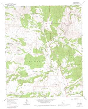
Alma Topo Map New Mexico
To zoom in, hover over the map of Alma
USGS Topo Quad 33108d8 - 1:24,000 scale
| Topo Map Name: | Alma |
| USGS Topo Quad ID: | 33108d8 |
| Print Size: | ca. 21 1/4" wide x 27" high |
| Southeast Coordinates: | 33.375° N latitude / 108.875° W longitude |
| Map Center Coordinates: | 33.4375° N latitude / 108.9375° W longitude |
| U.S. State: | NM |
| Filename: | o33108d8.jpg |
| Download Map JPG Image: | Alma topo map 1:24,000 scale |
| Map Type: | Topographic |
| Topo Series: | 7.5´ |
| Map Scale: | 1:24,000 |
| Source of Map Images: | United States Geological Survey (USGS) |
| Alternate Map Versions: |
Alma NM 1963, updated 1966 Download PDF Buy paper map Alma NM 1963, updated 1980 Download PDF Buy paper map Alma NM 1999, updated 2002 Download PDF Buy paper map Alma NM 2011 Download PDF Buy paper map Alma NM 2013 Download PDF Buy paper map Alma NM 2017 Download PDF Buy paper map |
| FStopo: | US Forest Service topo Alma is available: Download FStopo PDF Download FStopo TIF |
1:24,000 Topo Quads surrounding Alma
> Back to 33108a1 at 1:100,000 scale
> Back to 33108a1 at 1:250,000 scale
> Back to U.S. Topo Maps home
Alma topo map: Gazetteer
Alma: Flats
Hicks Pasture elevation 1568m 5144′Weedy Flat elevation 1636m 5367′
Alma: Populated Places
Alma elevation 1488m 4881′Alma: Post Offices
Alma Post Office (historical) elevation 1488m 4881′Alma: Reservoirs
Alma Flat Tank elevation 1537m 5042′Alma Tank elevation 1564m 5131′
Alma Water Storage Tank elevation 1601m 5252′
Balke Tank elevation 1610m 5282′
Basin Tank elevation 1594m 5229′
CCC Tank elevation 1667m 5469′
Copper Creek Water Storage Tank elevation 1610m 5282′
Ditch Tank elevation 1516m 4973′
Ellis Tank elevation 1575m 5167′
Ellis Tank elevation 1577m 5173′
Hanging Rocks Tank elevation 1731m 5679′
Hells Here Tank elevation 1606m 5269′
Hick Water Storage Tank elevation 1556m 5104′
Highway Tank elevation 1511m 4957′
Hollimon Tank elevation 1532m 5026′
Indian Hill Tank elevation 1611m 5285′
Jeep Tank elevation 1645m 5396′
Joe Day Tank elevation 1575m 5167′
Joe Tank elevation 1574m 5164′
John Tank elevation 1557m 5108′
Jones Draw Tank elevation 1626m 5334′
Juniper Tank elevation 1609m 5278′
Leaky Tank elevation 1526m 5006′
Little Round Mountain Tank elevation 1632m 5354′
Long Canyon Water Storage Tank elevation 1805m 5921′
New Tank elevation 1585m 5200′
Pipeline Tank elevation 1728m 5669′
Pothole Tank elevation 1560m 5118′
Section Five Tank elevation 1565m 5134′
Section Thirty-six Tank elevation 1611m 5285′
Section Twenty Tank elevation 1555m 5101′
Section Two Tank elevation 1635m 5364′
Sun Tank elevation 1671m 5482′
Thompson Tank elevation 1513m 4963′
Twin Sister Tank Number One elevation 1685m 5528′
Twin Sister Tank Number Two elevation 1667m 5469′
Wylie Morgan Tank elevation 1636m 5367′
Alma: Springs
Beaver Spring elevation 1548m 5078′Alma: Streams
Deep Creek elevation 1533m 5029′Devils Creek elevation 1566m 5137′
Mineral Creek elevation 1481m 4858′
Pueblo Creek elevation 1521m 4990′
Alma: Summits
Cradle Mesa elevation 1748m 5734′Indian Hill elevation 1768m 5800′
Indian Peak elevation 1930m 6332′
Little Round Mountain elevation 1688m 5538′
Racetrack Mesa elevation 1655m 5429′
Round Mountain elevation 1721m 5646′
Spurgeon Mesa elevation 1638m 5374′
Sunflower Mesa elevation 1709m 5606′
Alma: Valleys
Beaver Canyon elevation 1598m 5242′Brushy Canyon elevation 1548m 5078′
Buzzard Canyon elevation 1615m 5298′
Keller Canyon elevation 1493m 4898′
Kelly Canyon elevation 1498m 4914′
Long Canyon elevation 1537m 5042′
Vigil Canyon elevation 1620m 5314′
Alma digital topo map on disk
Buy this Alma topo map showing relief, roads, GPS coordinates and other geographical features, as a high-resolution digital map file on DVD:


