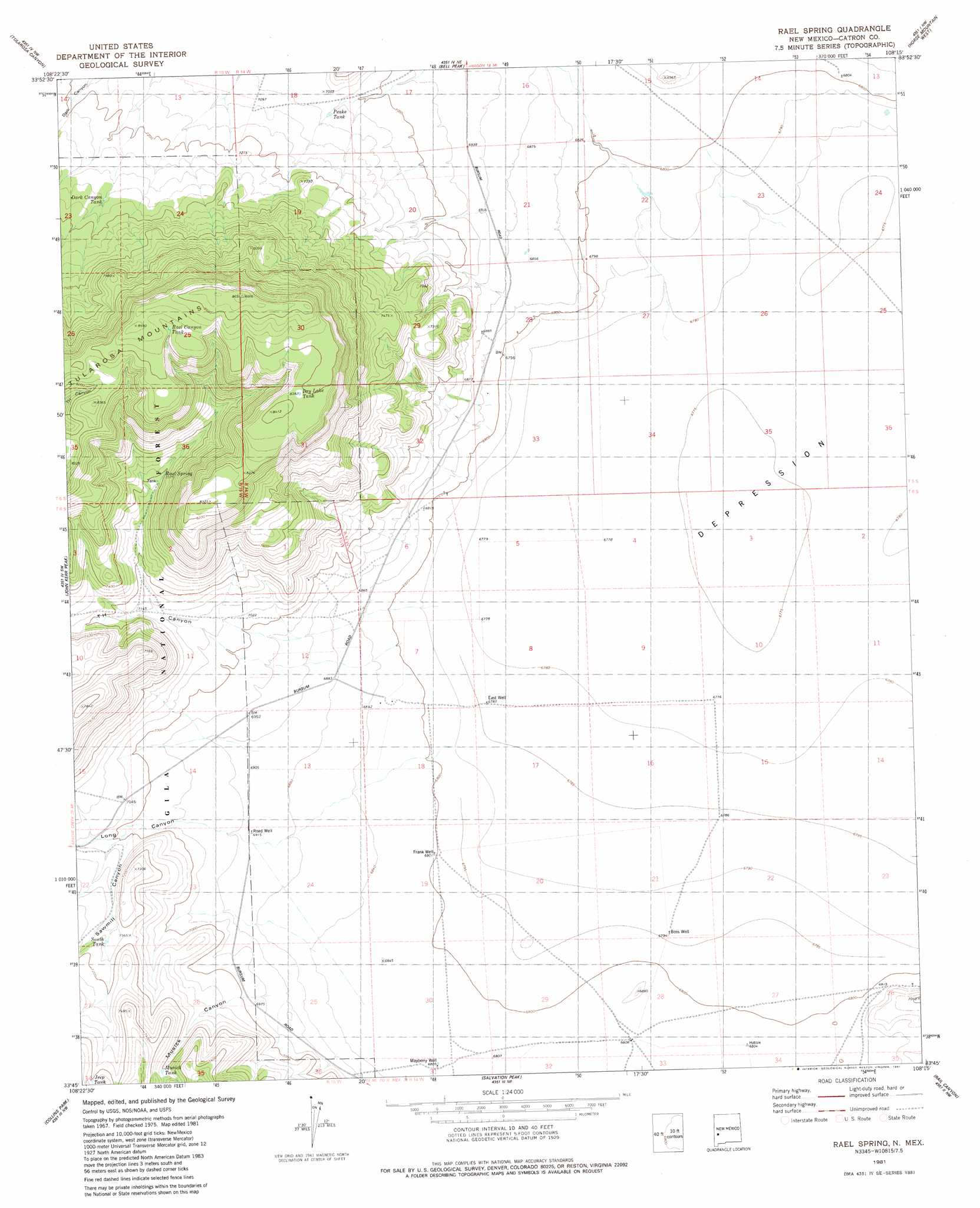
Rael Spring Topo Map New Mexico
To zoom in, hover over the map of Rael Spring
USGS Topo Quad 33108g3 - 1:24,000 scale
| Topo Map Name: | Rael Spring |
| USGS Topo Quad ID: | 33108g3 |
| Print Size: | ca. 21 1/4" wide x 27" high |
| Southeast Coordinates: | 33.75° N latitude / 108.25° W longitude |
| Map Center Coordinates: | 33.8125° N latitude / 108.3125° W longitude |
| U.S. State: | NM |
| Filename: | o33108g3.jpg |
| Download Map JPG Image: | Rael Spring topo map 1:24,000 scale |
| Map Type: | Topographic |
| Topo Series: | 7.5´ |
| Map Scale: | 1:24,000 |
| Source of Map Images: | United States Geological Survey (USGS) |
| Alternate Map Versions: |
Rael Spring NM 1981, updated 1981 Download PDF Buy paper map Rael Spring NM 1999, updated 2002 Download PDF Buy paper map Rael Spring NM 2011 Download PDF Buy paper map Rael Spring NM 2013 Download PDF Buy paper map Rael Spring NM 2017 Download PDF Buy paper map |
| FStopo: | US Forest Service topo Rael Spring is available: Download FStopo PDF Download FStopo TIF |
1:24,000 Topo Quads surrounding Rael Spring
Gallo Mountains East |
Slaughter Mesa |
Mangas Mountain |
Wallace Mesa |
Log Canyon |
Aragon |
Tullarosa Canyon |
Bell Peak |
Horse Mountain West |
Horse Mountain East |
Squirrel Springs Canyon |
John Kerr Peak |
Rael Spring |
Fullerton |
Shaw Mountain |
Eagle Peak |
Collins Park |
Salvation Peak |
Rail Canyon |
Pelona Mountain |
Telephone Canyon |
Pitchfork Canyon |
O Bar O Canyon West |
O Bar O Canyon East |
Indian Peaks West |
> Back to 33108e1 at 1:100,000 scale
> Back to 33108a1 at 1:250,000 scale
> Back to U.S. Topo Maps home
Rael Spring topo map: Gazetteer
Rael Spring: Reservoirs
Dark Canyon Tank elevation 2231m 7319′Dry Lake Tank elevation 2559m 8395′
Jeep Tank elevation 2263m 7424′
Musick Tank elevation 2198m 7211′
Peak Tank elevation 2154m 7066′
Rael Canyon Tank elevation 2570m 8431′
South Tank elevation 2179m 7148′
Rael Spring: Springs
Rael Canyon elevation 2253m 7391′Rael Spring elevation 2254m 7395′
Rael Spring: Valleys
Long Canyon elevation 2115m 6938′Musick Canyon elevation 2116m 6942′
Sawmill Canyon elevation 2184m 7165′
T H Canyon elevation 2073m 6801′
Rael Spring: Wells
Boss Well elevation 2072m 6797′East Well elevation 2069m 6788′
Frank Well elevation 2074m 6804′
Frank Well elevation 2071m 6794′
Mayberry Well elevation 2077m 6814′
Road Well elevation 2108m 6916′
Rael Spring digital topo map on disk
Buy this Rael Spring topo map showing relief, roads, GPS coordinates and other geographical features, as a high-resolution digital map file on DVD: