Tullarosa Canyon Topo Map New Mexico
To zoom in, hover over the map of Tullarosa Canyon
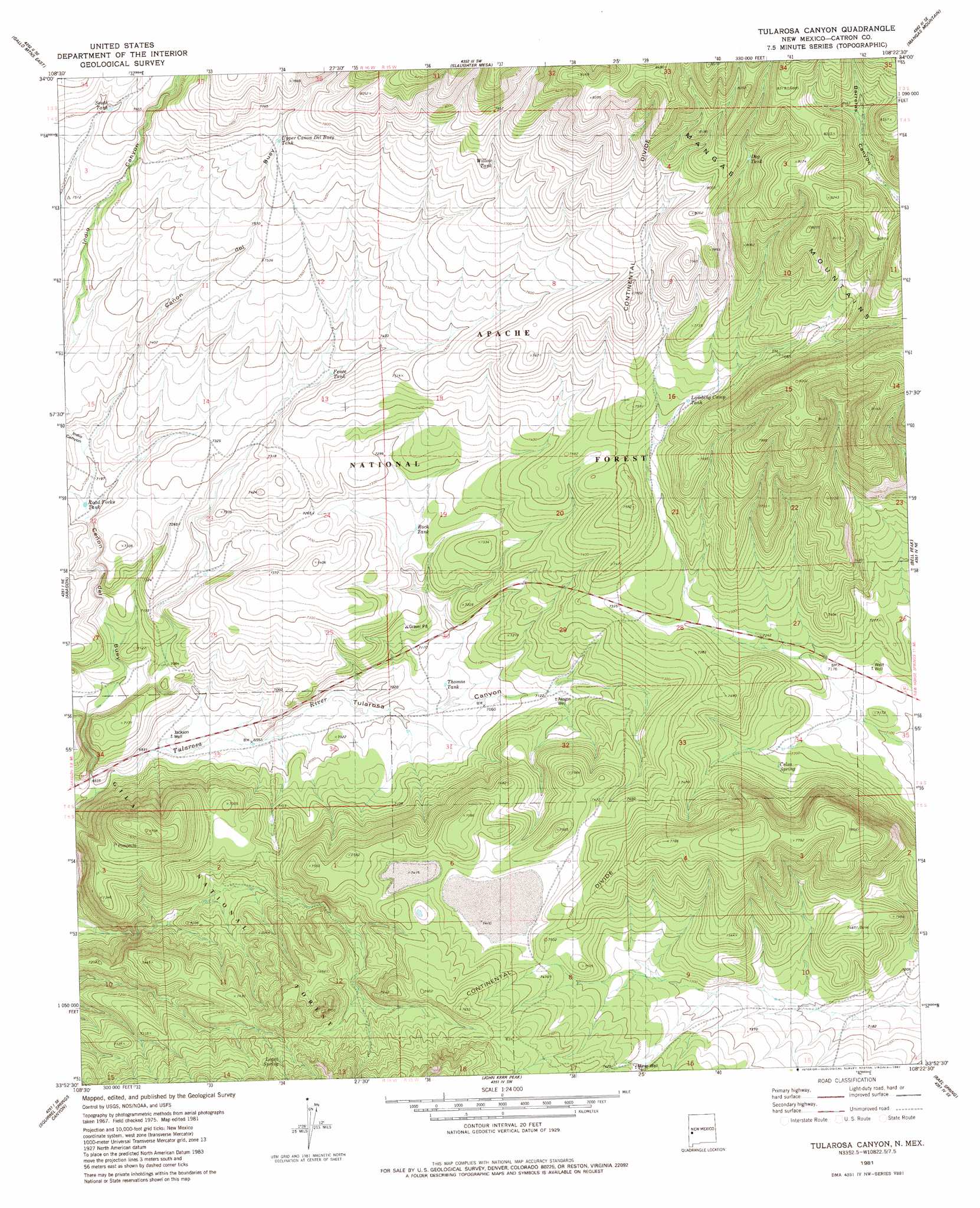
USGS Topo Quad 33108h4 - 1:24,000 scale
| Topo Map Name: | Tullarosa Canyon |
| USGS Topo Quad ID: | 33108h4 |
| Print Size: | ca. 21 1/4" wide x 27" high |
| Southeast Coordinates: | 33.875° N latitude / 108.375° W longitude |
| Map Center Coordinates: | 33.9375° N latitude / 108.4375° W longitude |
| U.S. State: | NM |
| Filename: | o33108h4.jpg |
| Download Map JPG Image: | Tullarosa Canyon topo map 1:24,000 scale |
| Map Type: | Topographic |
| Topo Series: | 7.5´ |
| Map Scale: | 1:24,000 |
| Source of Map Images: | United States Geological Survey (USGS) |
| Alternate Map Versions: |
Tularosa Canyon NM 1981, updated 1981 Download PDF Buy paper map Tularosa Canyon NM 1999, updated 2002 Download PDF Buy paper map Tularosa Canyon NM 2011 Download PDF Buy paper map Tularosa Canyon NM 2013 Download PDF Buy paper map Tularosa Canyon NM 2017 Download PDF Buy paper map |
| FStopo: | US Forest Service topo Tularosa Canyon is available: Download FStopo PDF Download FStopo TIF |
1:24,000 Topo Quads surrounding Tullarosa Canyon
Pondersoa Tank |
Largo Mesa |
Escondido Mountains |
Mangas |
Alegres Mountain |
Gallo Mountains West |
Gallo Mountains East |
Slaughter Mesa |
Mangas Mountain |
Wallace Mesa |
Queens Head |
Aragon |
Tullarosa Canyon |
Bell Peak |
Horse Mountain West |
Cruzville |
Squirrel Springs Canyon |
John Kerr Peak |
Rael Spring |
Fullerton |
Milligan Mountain |
Eagle Peak |
Collins Park |
Salvation Peak |
Rail Canyon |
> Back to 33108e1 at 1:100,000 scale
> Back to 33108a1 at 1:250,000 scale
> Back to U.S. Topo Maps home
Tullarosa Canyon topo map: Gazetteer
Tullarosa Canyon: Flats
Sand Flats elevation 2236m 7335′Tullarosa Canyon: Lakes
Patterson Pond elevation 2316m 7598′Tullarosa Canyon: Reservoirs
Attavesudo Tank elevation 2335m 7660′Dog Tank elevation 2424m 7952′
Fence Tank elevation 2243m 7358′
GC Number Seven Tank elevation 2173m 7129′
GC Number Six Tank elevation 2121m 6958′
Lambing Camp Tank elevation 2291m 7516′
Poacher Tank elevation 2451m 8041′
Road Forks Tank elevation 2188m 7178′
Rock Tank elevation 2205m 7234′
South Tank elevation 2316m 7598′
Thomas Tank elevation 2150m 7053′
Upper Canondel Buey Tank elevation 2334m 7657′
Willow Tank elevation 2370m 7775′
Tullarosa Canyon: Springs
Celso Spring elevation 2203m 7227′Lopez Spring elevation 2313m 7588′
Tullarosa Canyon: Valleys
Canon del Buey elevation 2099m 6886′Indio Canyon elevation 2200m 7217′
Sand Flat Canyon elevation 2106m 6909′
Tularosa Canyon elevation 2134m 7001′
Tullarosa Canyon: Wells
10007 Water Well elevation 2123m 6965′Aragon Water Well elevation 2177m 7142′
Jackson Well elevation 2118m 6948′
Miner Water Well elevation 2259m 7411′
West Well elevation 2182m 7158′
Tullarosa Canyon digital topo map on disk
Buy this Tullarosa Canyon topo map showing relief, roads, GPS coordinates and other geographical features, as a high-resolution digital map file on DVD: