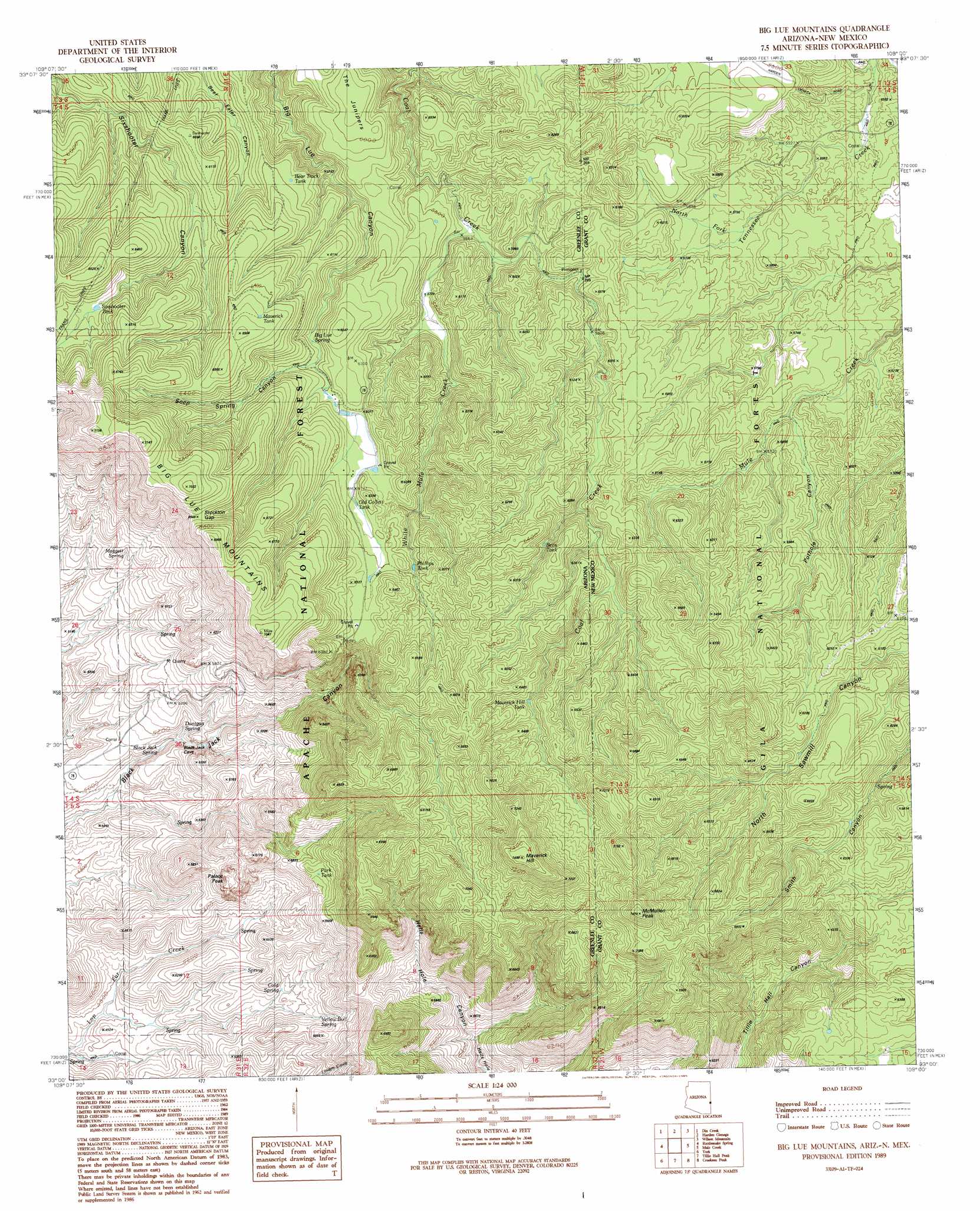
Big Lue Mountains Topo Map Arizona
To zoom in, hover over the map of Big Lue Mountains
USGS Topo Quad 33109a1 - 1:24,000 scale
| Topo Map Name: | Big Lue Mountains |
| USGS Topo Quad ID: | 33109a1 |
| Print Size: | ca. 21 1/4" wide x 27" high |
| Southeast Coordinates: | 33° N latitude / 109° W longitude |
| Map Center Coordinates: | 33.0625° N latitude / 109.0625° W longitude |
| U.S. States: | AZ, NM |
| Filename: | o33109a1.jpg |
| Download Map JPG Image: | Big Lue Mountains topo map 1:24,000 scale |
| Map Type: | Topographic |
| Topo Series: | 7.5´ |
| Map Scale: | 1:24,000 |
| Source of Map Images: | United States Geological Survey (USGS) |
| Alternate Map Versions: |
Big Lue Mountains AZ 1989, updated 1989 Download PDF Buy paper map Big Lue Mountains AZ 1997, updated 2000 Download PDF Buy paper map Big Lue Mountains AZ 2005, updated 2006 Download PDF Buy paper map Big Lue Mountains AZ 2011 Download PDF Buy paper map Big Lue Mountains AZ 2014 Download PDF Buy paper map |
| FStopo: | US Forest Service topo Big Lue Mountains is available: Download FStopo PDF Download FStopo TIF |
1:24,000 Topo Quads surrounding Big Lue Mountains
Pipestem Mountain |
Fritz Canyon |
Maple Peak |
Glenwood |
Holt Mountain |
Mitchell Peak |
Dix Creek |
Harden Cienega |
Wilson Mountain |
Moon Ranch |
Clifton |
Rattlesnake Spring |
Big Lue Mountains |
Mule Creek |
Bear Mountain |
Guthrie |
York |
Tillie Hall Peak |
Crookson Peak |
Applegate Mountain |
Ash Peak |
Sheldon |
Goat Camp Spring |
Steeple Rock |
Walker Canyon |
> Back to 33109a1 at 1:100,000 scale
> Back to 33108a1 at 1:250,000 scale
> Back to U.S. Topo Maps home
Big Lue Mountains topo map: Gazetteer
Big Lue Mountains: Basins
Maverick Basin elevation 1979m 6492′Big Lue Mountains: Gaps
Needles Eye elevation 1860m 6102′Stockton Gap elevation 2023m 6637′
Big Lue Mountains: Reservoirs
Ball Tank elevation 1891m 6204′Ball Tank elevation 1865m 6118′
Base Tanks elevation 1856m 6089′
Base Tanks elevation 1835m 6020′
Bear Tank elevation 1857m 6092′
Bear Tank elevation 1848m 6062′
Bear Track Tank elevation 1820m 5971′
Bens Tank elevation 1869m 6131′
Blackjack Tank elevation 1946m 6384′
Coal Creek Tank elevation 1783m 5849′
Coal Creek Tank elevation 1803m 5915′
Corral Tank elevation 1804m 5918′
Corral Tank elevation 1814m 5951′
Fence Line Tank elevation 1721m 5646′
Fence Line Tank elevation 1732m 5682′
Holdup Ground Tank elevation 1777m 5830′
Jeffers Tank elevation 1832m 6010′
Jeffers Tank elevation 1829m 6000′
Line Tank elevation 1796m 5892′
Line Tank elevation 1790m 5872′
Maverick Hill Tank elevation 1905m 6250′
Maverick Tank elevation 1974m 6476′
Neck Tank elevation 1793m 5882′
Neck Tank elevation 1793m 5882′
Old Callett Tank elevation 1856m 6089′
Old Collett Tank elevation 1859m 6099′
Park Tank elevation 1793m 5882′
Partnership Tank elevation 1746m 5728′
Partnership Tank elevation 1751m 5744′
Phillips Tank elevation 1880m 6167′
Pinyon Tank elevation 1886m 6187′
Pinyon Tank elevation 1877m 6158′
Pothole Tank elevation 1755m 5757′
Pothole Tank elevation 1765m 5790′
Rock Bottom Tank elevation 1715m 5626′
Rock Bottom Tank elevation 1709m 5606′
Sixshooter Tank elevation 1868m 6128′
Tennessee Tank elevation 1778m 5833′
Tennessee Tank elevation 1774m 5820′
West Coal Creek Well elevation 1766m 5793′
Winchester Tank elevation 1922m 6305′
Winchester Tank elevation 1922m 6305′
Big Lue Mountains: Springs
Bee Tree Spring elevation 1559m 5114′Bee Tree Spring elevation 1562m 5124′
Big Lue Spring elevation 1821m 5974′
Big Lue Spring elevation 1808m 5931′
Black Jack Spring elevation 1529m 5016′
Cold Spring elevation 1570m 5150′
Cottonwood Spring elevation 1544m 5065′
Dunigan Spring elevation 1564m 5131′
Lost Spring elevation 1595m 5232′
Lower Bee Tree Spring elevation 1482m 4862′
Maggett Spring elevation 1694m 5557′
Mexican Spring elevation 1569m 5147′
Mexican Spring elevation 1550m 5085′
Pig Pen Spring elevation 1628m 5341′
Red Spring elevation 1674m 5492′
Sluff Spring elevation 1676m 5498′
Sweet Spring elevation 1484m 4868′
Upper Hells Hole Spring elevation 1588m 5209′
Willis Spring elevation 1671m 5482′
Yellow Bull Spring elevation 1614m 5295′
Yellow Bull Spring elevation 1622m 5321′
Big Lue Mountains: Streams
North Fork Tennessee Creek elevation 1723m 5652′White Mule Creek elevation 1722m 5649′
Big Lue Mountains: Summits
Big Lue Mountains elevation 2139m 7017′Maverick Hill elevation 2280m 7480′
McMullen Peak elevation 2271m 7450′
Palace Peak elevation 1788m 5866′
Big Lue Mountains: Valleys
Deer Canyon elevation 1463m 4799′Pothole Canyon elevation 1734m 5688′
Seep Spring Canyon elevation 1821m 5974′
Big Lue Mountains: Wells
White Mule Windmill elevation 1737m 5698′Big Lue Mountains: Woods
The Junipers elevation 1793m 5882′Big Lue Mountains digital topo map on disk
Buy this Big Lue Mountains topo map showing relief, roads, GPS coordinates and other geographical features, as a high-resolution digital map file on DVD: