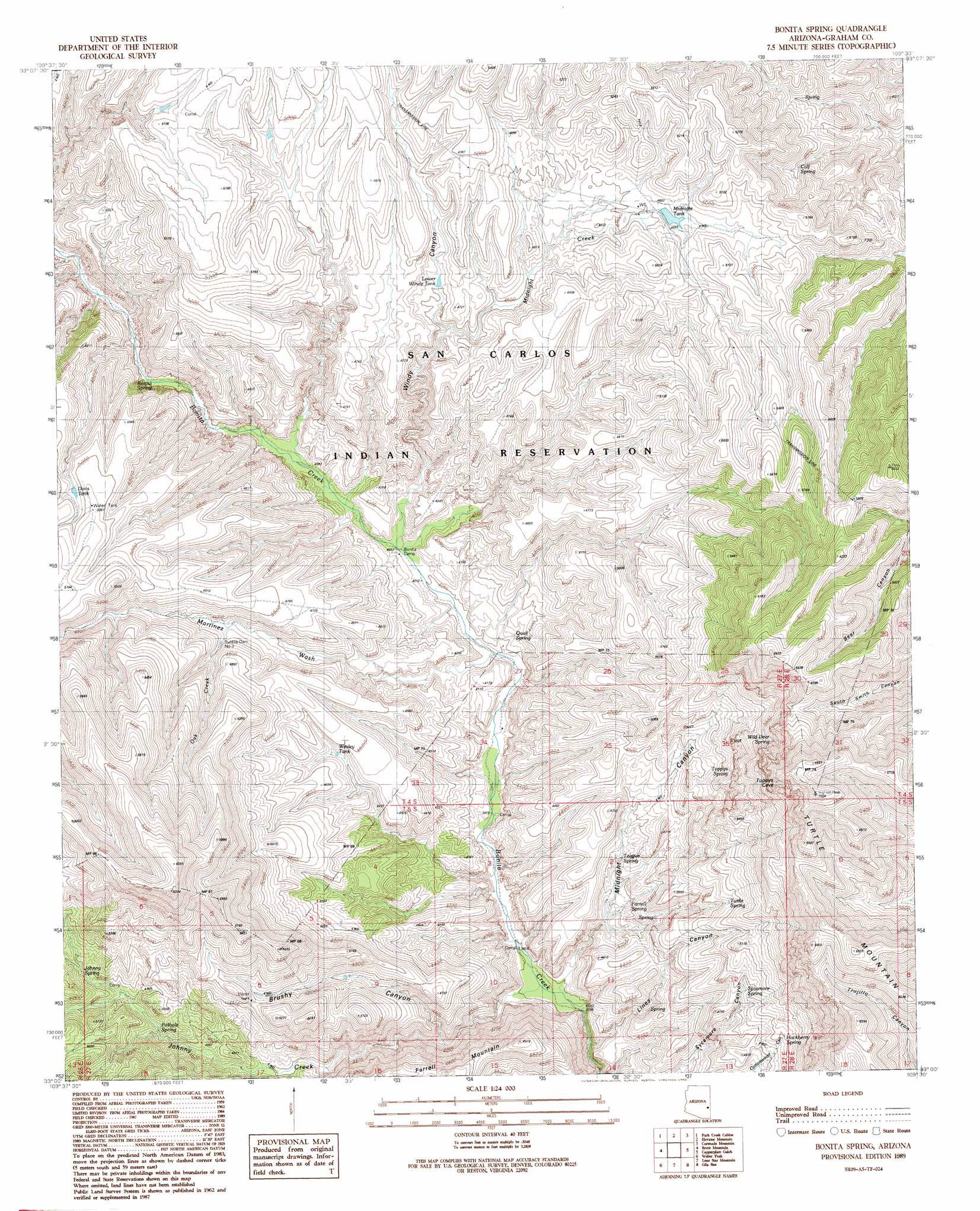
Bonita Spring Topo Map Arizona
To zoom in, hover over the map of Bonita Spring
USGS Topo Quad 33109a5 - 1:24,000 scale
| Topo Map Name: | Bonita Spring |
| USGS Topo Quad ID: | 33109a5 |
| Print Size: | ca. 21 1/4" wide x 27" high |
| Southeast Coordinates: | 33° N latitude / 109.5° W longitude |
| Map Center Coordinates: | 33.0625° N latitude / 109.5625° W longitude |
| U.S. State: | AZ |
| Filename: | o33109a5.jpg |
| Download Map JPG Image: | Bonita Spring topo map 1:24,000 scale |
| Map Type: | Topographic |
| Topo Series: | 7.5´ |
| Map Scale: | 1:24,000 |
| Source of Map Images: | United States Geological Survey (USGS) |
| Alternate Map Versions: |
Bonita Spring AZ 1989, updated 1990 Download PDF Buy paper map Bonita Spring AZ 2011 Download PDF Buy paper map Bonita Spring AZ 2014 Download PDF Buy paper map |
1:24,000 Topo Quads surrounding Bonita Spring
Point Of Pines West |
Point Of Pines East |
Willow Mountain Se |
Bee Canyon |
Pipestem Mountain |
Bonita Tank |
Park Creek Cabins |
Elevator Mountain |
Coronado Mountain |
Mitchell Peak |
Markham Creek |
Bryce Mountain |
Bonita Spring |
Copperplate Gulch |
Clifton |
Pima |
Weber Peak |
Lone Star Mountain |
Gila Box |
Guthrie |
Thatcher |
Safford |
San Jose |
Tollgate Tank |
Ash Peak |
> Back to 33109a1 at 1:100,000 scale
> Back to 33108a1 at 1:250,000 scale
> Back to U.S. Topo Maps home
Bonita Spring topo map: Gazetteer
Bonita Spring: Dams
Midnight Dam elevation 1533m 5029′Rubble Dam elevation 1494m 4901′
Rubble Dam Three elevation 0m 0′
Bonita Spring: Reservoirs
Dons Tank elevation 1503m 4931′Lower Windy Tank elevation 1404m 4606′
Midnight Tank elevation 1475m 4839′
Wesley Tank elevation 1350m 4429′
Bonita Spring: Springs
Bonita Spring elevation 1274m 4179′Calf Spring elevation 1387m 4550′
Cottonwood Spring elevation 1394m 4573′
Farrell Spring elevation 1268m 4160′
Hackberry Spring elevation 1465m 4806′
Johnny Spring elevation 1452m 4763′
Pothole Spring elevation 1413m 4635′
Quail Spring elevation 1231m 4038′
Sycamore Spring elevation 1436m 4711′
Teague Spring elevation 1281m 4202′
Toppys Spring elevation 1544m 5065′
Turtle Spring elevation 1486m 4875′
Wild Deer Spring elevation 1739m 5705′
Bonita Spring: Streams
Johnny Creek elevation 1150m 3772′Martinez Wash elevation 1252m 4107′
Midnight Creek elevation 1377m 4517′
Oak Creek elevation 1375m 4511′
Bonita Spring: Summits
Farrell Mountain elevation 1514m 4967′Turkey Mountain elevation 1596m 5236′
Turtle Mountain elevation 2126m 6975′
Bonita Spring: Valleys
Brushy Canyon elevation 1268m 4160′Lines Canyon elevation 1192m 3910′
Midnight Canyon elevation 1162m 3812′
Windy Canyon elevation 1264m 4146′
Bonita Spring digital topo map on disk
Buy this Bonita Spring topo map showing relief, roads, GPS coordinates and other geographical features, as a high-resolution digital map file on DVD: