Bryce Mountain Topo Map Arizona
To zoom in, hover over the map of Bryce Mountain
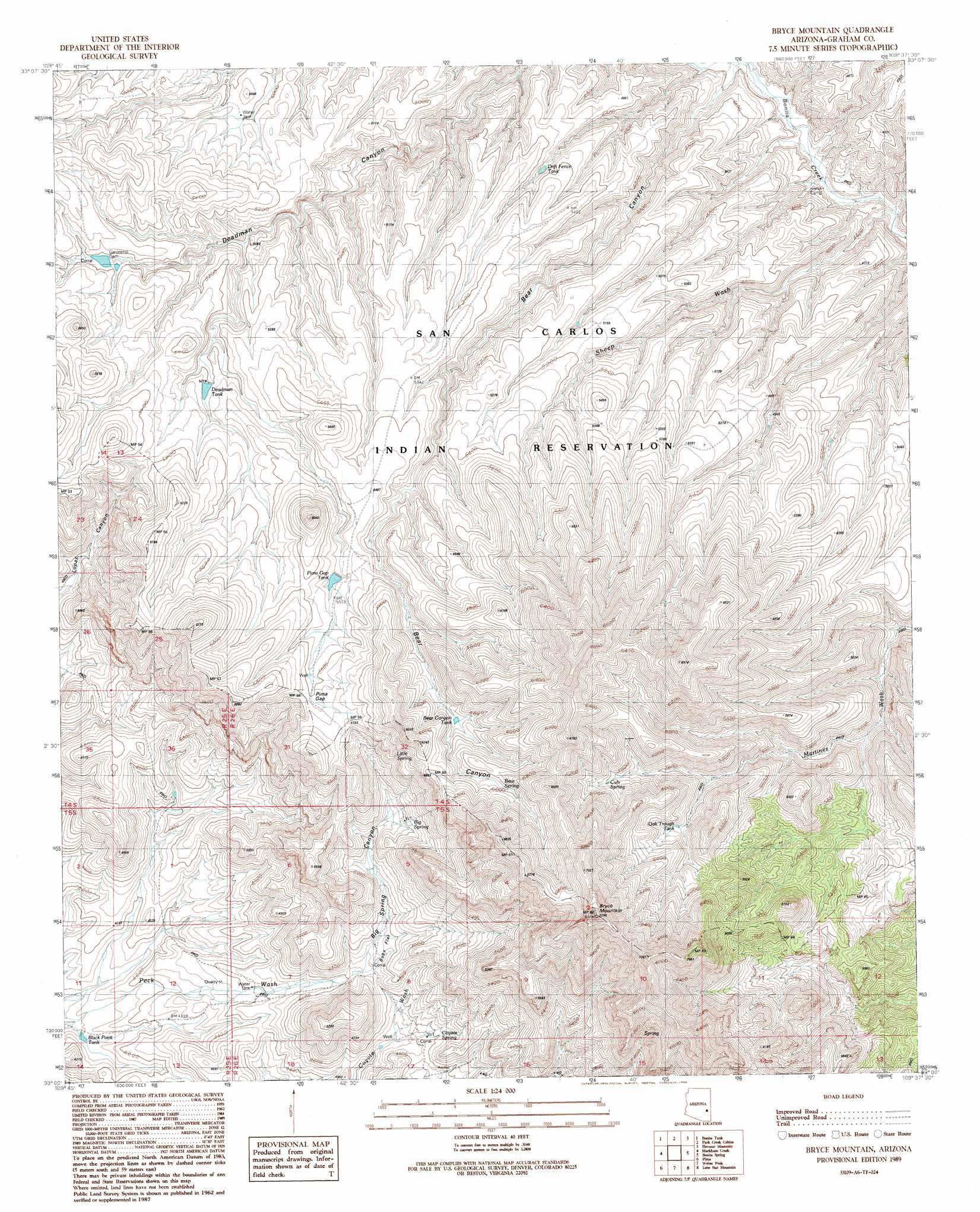
USGS Topo Quad 33109a6 - 1:24,000 scale
| Topo Map Name: | Bryce Mountain |
| USGS Topo Quad ID: | 33109a6 |
| Print Size: | ca. 21 1/4" wide x 27" high |
| Southeast Coordinates: | 33° N latitude / 109.625° W longitude |
| Map Center Coordinates: | 33.0625° N latitude / 109.6875° W longitude |
| U.S. State: | AZ |
| Filename: | o33109a6.jpg |
| Download Map JPG Image: | Bryce Mountain topo map 1:24,000 scale |
| Map Type: | Topographic |
| Topo Series: | 7.5´ |
| Map Scale: | 1:24,000 |
| Source of Map Images: | United States Geological Survey (USGS) |
| Alternate Map Versions: |
Bryce Mountain AZ 1989, updated 1990 Download PDF Buy paper map Bryce Mountain AZ 2011 Download PDF Buy paper map Bryce Mountain AZ 2014 Download PDF Buy paper map |
1:24,000 Topo Quads surrounding Bryce Mountain
Tule Tubs |
Point Of Pines West |
Point Of Pines East |
Willow Mountain Se |
Bee Canyon |
Gila Peak |
Bonita Tank |
Park Creek Cabins |
Elevator Mountain |
Coronado Mountain |
Fort Thomas |
Markham Creek |
Bryce Mountain |
Bonita Spring |
Copperplate Gulch |
Eden |
Pima |
Weber Peak |
Lone Star Mountain |
Gila Box |
Shingle Mill Mountain |
Thatcher |
Safford |
San Jose |
Tollgate Tank |
> Back to 33109a1 at 1:100,000 scale
> Back to 33108a1 at 1:250,000 scale
> Back to U.S. Topo Maps home
Bryce Mountain topo map: Gazetteer
Bryce Mountain: Dams
Geronimo Dam elevation 1573m 5160′Rubble Number One Dam elevation 1645m 5396′
Bryce Mountain: Flats
Bobs Flat elevation 1449m 4753′Bryce Mountain: Gaps
Pima Gap elevation 1717m 5633′Bryce Mountain: Reservoirs
Airplane Canyon Tank elevation 1502m 4927′Bear Canyon Tank elevation 1734m 5688′
Black Point Tank elevation 1246m 4087′
Deadman Tank elevation 1587m 5206′
Drift Fence Tank elevation 1482m 4862′
Oak Trough Tank elevation 1723m 5652′
Pima Gap Tank elevation 1670m 5479′
Bryce Mountain: Springs
Bear Spring elevation 1815m 5954′Big Spring elevation 1597m 5239′
Coyote Spring elevation 1408m 4619′
Cub Spring elevation 1772m 5813′
Hells Dive Spring elevation 1541m 5055′
Little Spring elevation 1693m 5554′
Bryce Mountain: Streams
Park Creek elevation 1336m 4383′Sheep Wash elevation 0m 0′
Bryce Mountain: Summits
Bryce Mountain elevation 2219m 7280′Bryce Mountain: Valleys
Bear Canyon elevation 1369m 4491′Big Spring Canyon elevation 1415m 4642′
Bryce Mountain digital topo map on disk
Buy this Bryce Mountain topo map showing relief, roads, GPS coordinates and other geographical features, as a high-resolution digital map file on DVD: