Markham Creek Topo Map Arizona
To zoom in, hover over the map of Markham Creek
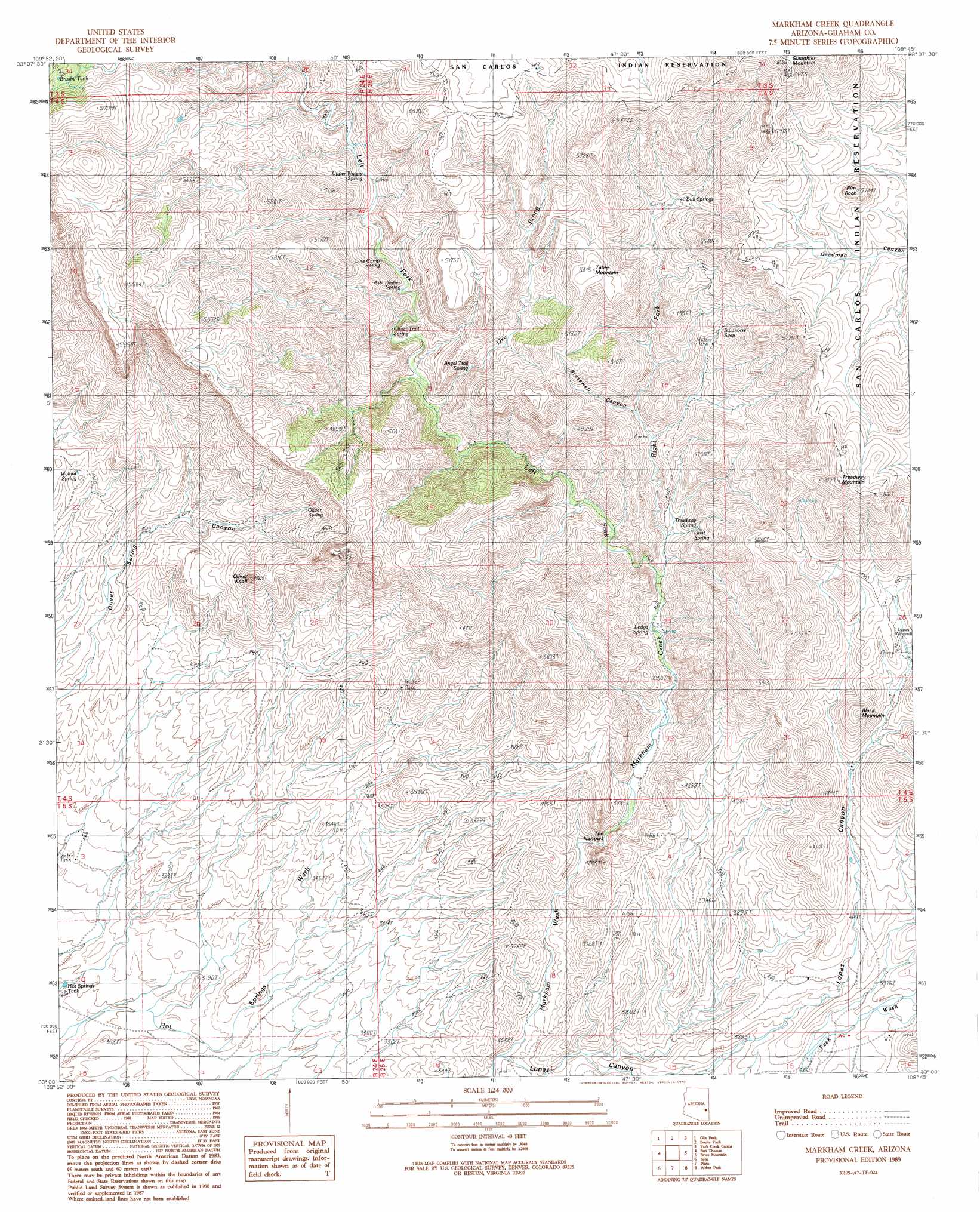
USGS Topo Quad 33109a7 - 1:24,000 scale
| Topo Map Name: | Markham Creek |
| USGS Topo Quad ID: | 33109a7 |
| Print Size: | ca. 21 1/4" wide x 27" high |
| Southeast Coordinates: | 33° N latitude / 109.75° W longitude |
| Map Center Coordinates: | 33.0625° N latitude / 109.8125° W longitude |
| U.S. State: | AZ |
| Filename: | o33109a7.jpg |
| Download Map JPG Image: | Markham Creek topo map 1:24,000 scale |
| Map Type: | Topographic |
| Topo Series: | 7.5´ |
| Map Scale: | 1:24,000 |
| Source of Map Images: | United States Geological Survey (USGS) |
| Alternate Map Versions: |
Markham Creek AZ 1989, updated 1990 Download PDF Buy paper map Markham Creek AZ 2011 Download PDF Buy paper map Markham Creek AZ 2014 Download PDF Buy paper map |
1:24,000 Topo Quads surrounding Markham Creek
Ash Creek Ranch |
Tule Tubs |
Point Of Pines West |
Point Of Pines East |
Willow Mountain Se |
Bylas |
Gila Peak |
Bonita Tank |
Park Creek Cabins |
Elevator Mountain |
Geronimo |
Fort Thomas |
Markham Creek |
Bryce Mountain |
Bonita Spring |
Telegraph Wash |
Eden |
Pima |
Weber Peak |
Lone Star Mountain |
Tripp Canyon |
Shingle Mill Mountain |
Thatcher |
Safford |
San Jose |
> Back to 33109a1 at 1:100,000 scale
> Back to 33108a1 at 1:250,000 scale
> Back to U.S. Topo Maps home
Markham Creek topo map: Gazetteer
Markham Creek: Gaps
The Narrows elevation 1082m 3549′Markham Creek: Ranges
Gila Mountains elevation 1560m 5118′Markham Creek: Reservoirs
Brushy Tank elevation 1610m 5282′Hot Springs Tank elevation 903m 2962′
Markham Creek: Springs
Angel Trail Spring elevation 1356m 4448′Ash Timber Spring elevation 1323m 4340′
Bull Springs elevation 1458m 4783′
Goat Spring elevation 1265m 4150′
Ledge Spring elevation 1143m 3750′
Left Hand Spring elevation 1177m 3861′
Line Camp Spring elevation 1327m 4353′
Oliver Spring elevation 1308m 4291′
Oliver Trail Spring elevation 1289m 4229′
Studhorse Seep elevation 1421m 4662′
Treadway Spring elevation 1330m 4363′
Upper Waters Spring elevation 1361m 4465′
Walnut Spring elevation 1152m 3779′
Markham Creek: Streams
Big Spring Wash elevation 1183m 3881′Dry Prong elevation 1266m 4153′
Left Fork Markham Creek elevation 1168m 3832′
Markham Creek elevation 1109m 3638′
Right Fork Markham Creek elevation 1168m 3832′
Markham Creek: Summits
Black Mountain elevation 1500m 4921′Oliver Knoll elevation 1452m 4763′
Rim Rock elevation 1752m 5748′
Slaughter Mountain elevation 1991m 6532′
Table Mountain elevation 1615m 5298′
Treadway Mountain elevation 1796m 5892′
Markham Creek: Valleys
Brasswell Canyon elevation 1273m 4176′Lopas Canyon elevation 1017m 3336′
Markham Creek digital topo map on disk
Buy this Markham Creek topo map showing relief, roads, GPS coordinates and other geographical features, as a high-resolution digital map file on DVD: