Park Creek Cabins Topo Map Arizona
To zoom in, hover over the map of Park Creek Cabins
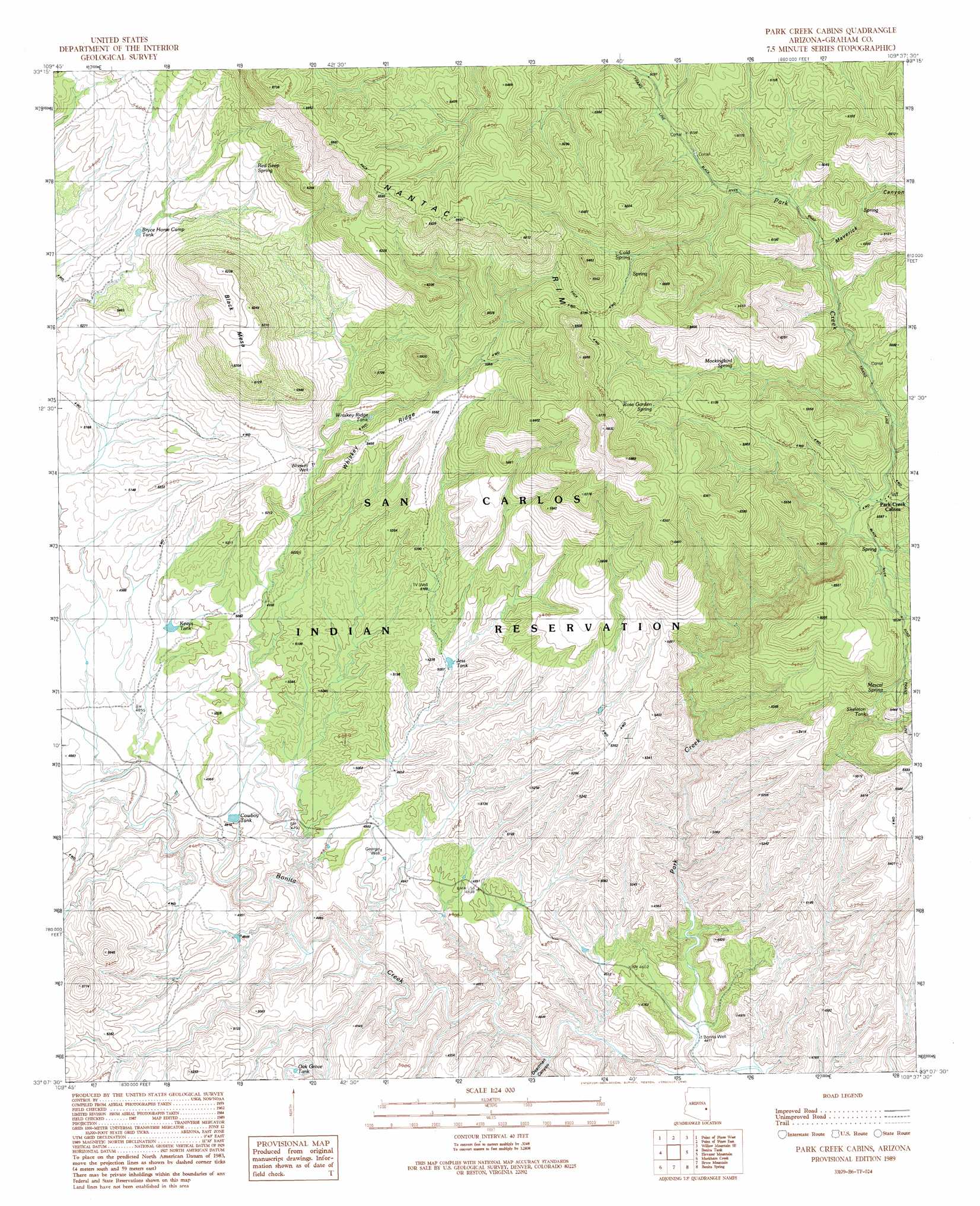
USGS Topo Quad 33109b6 - 1:24,000 scale
| Topo Map Name: | Park Creek Cabins |
| USGS Topo Quad ID: | 33109b6 |
| Print Size: | ca. 21 1/4" wide x 27" high |
| Southeast Coordinates: | 33.125° N latitude / 109.625° W longitude |
| Map Center Coordinates: | 33.1875° N latitude / 109.6875° W longitude |
| U.S. State: | AZ |
| Filename: | o33109b6.jpg |
| Download Map JPG Image: | Park Creek Cabins topo map 1:24,000 scale |
| Map Type: | Topographic |
| Topo Series: | 7.5´ |
| Map Scale: | 1:24,000 |
| Source of Map Images: | United States Geological Survey (USGS) |
| Alternate Map Versions: |
Park Creek Cabins AZ 1989, updated 1990 Download PDF Buy paper map Park Creek Cabins AZ 2011 Download PDF Buy paper map Park Creek Cabins AZ 2014 Download PDF Buy paper map |
1:24,000 Topo Quads surrounding Park Creek Cabins
Natanes Mountains Nw |
Natanes Mountains Ne |
Sawbuck Mountain |
Willow Mountain |
Robinson Mesa |
Tule Tubs |
Point Of Pines West |
Point Of Pines East |
Willow Mountain Se |
Bee Canyon |
Gila Peak |
Bonita Tank |
Park Creek Cabins |
Elevator Mountain |
Coronado Mountain |
Fort Thomas |
Markham Creek |
Bryce Mountain |
Bonita Spring |
Copperplate Gulch |
Eden |
Pima |
Weber Peak |
Lone Star Mountain |
Gila Box |
> Back to 33109a1 at 1:100,000 scale
> Back to 33108a1 at 1:250,000 scale
> Back to U.S. Topo Maps home
Park Creek Cabins topo map: Gazetteer
Park Creek Cabins: Reservoirs
Bryce Horse Camp Tank elevation 1621m 5318′Cowboy Tank elevation 1465m 4806′
Jesse Tank elevation 1538m 5045′
Keays Tank elevation 1507m 4944′
Oak Grove Tank elevation 1508m 4947′
Skeleton Tank elevation 0m 0′
Whiskey Ridge Tank elevation 1604m 5262′
Park Creek Cabins: Ridges
Whiskey Ridge elevation 1669m 5475′Park Creek Cabins: Springs
Cold Spring elevation 1825m 5987′Mescal Spring elevation 1641m 5383′
Mockingbird Spring elevation 1750m 5741′
Red Seep Spring elevation 1768m 5800′
Rose Garden Spring elevation 1874m 6148′
Webster Spring elevation 1670m 5479′
Park Creek Cabins: Summits
Black Mesa elevation 1885m 6184′Park Creek Cabins: Valleys
Deadman Canyon elevation 1368m 4488′Maverick Canyon elevation 1707m 5600′
Park Creek Cabins: Wells
Bonita Well elevation 1346m 4416′George Well elevation 1475m 4839′
One V Well elevation 1573m 5160′
Rainbow Well elevation 1516m 4973′
Whiskey Well elevation 1578m 5177′
Park Creek Cabins digital topo map on disk
Buy this Park Creek Cabins topo map showing relief, roads, GPS coordinates and other geographical features, as a high-resolution digital map file on DVD: