Rose Peak Topo Map Arizona
To zoom in, hover over the map of Rose Peak
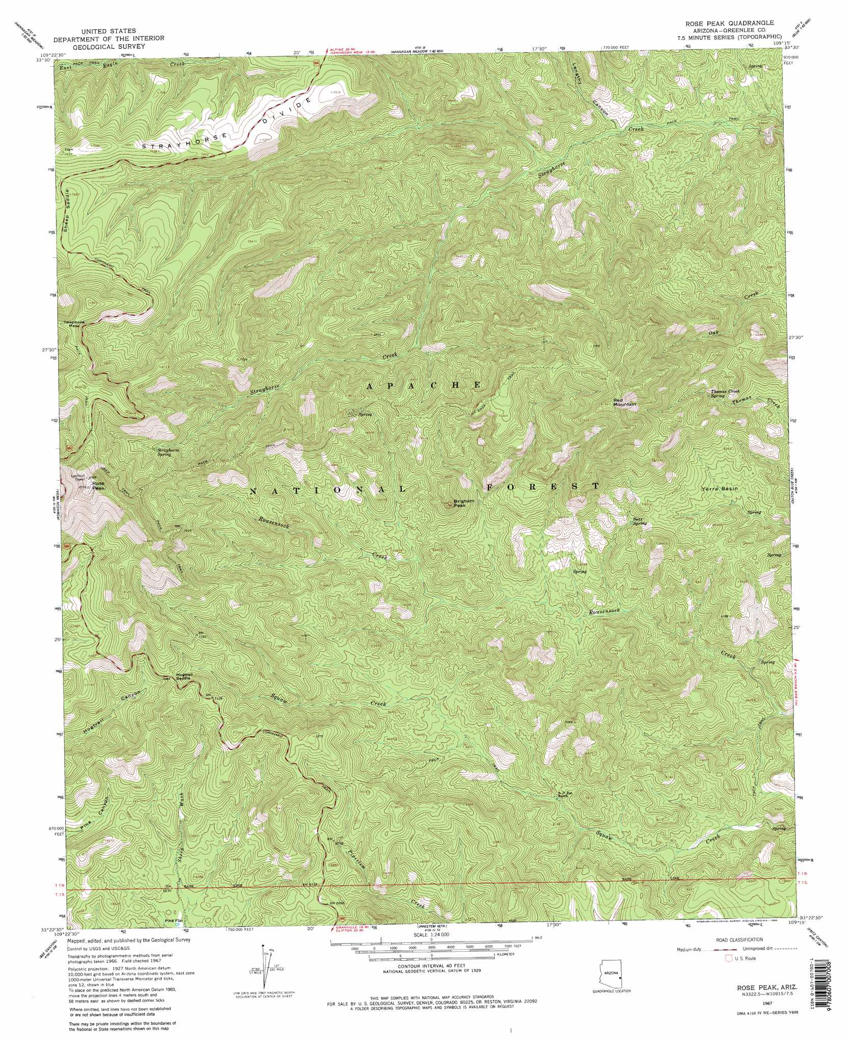
USGS Topo Quad 33109d3 - 1:24,000 scale
| Topo Map Name: | Rose Peak |
| USGS Topo Quad ID: | 33109d3 |
| Print Size: | ca. 21 1/4" wide x 27" high |
| Southeast Coordinates: | 33.375° N latitude / 109.25° W longitude |
| Map Center Coordinates: | 33.4375° N latitude / 109.3125° W longitude |
| U.S. State: | AZ |
| Filename: | o33109d3.jpg |
| Download Map JPG Image: | Rose Peak topo map 1:24,000 scale |
| Map Type: | Topographic |
| Topo Series: | 7.5´ |
| Map Scale: | 1:24,000 |
| Source of Map Images: | United States Geological Survey (USGS) |
| Alternate Map Versions: |
Rose Peak AZ 1967, updated 1970 Download PDF Buy paper map Rose Peak AZ 1967, updated 1980 Download PDF Buy paper map Rose Peak AZ 1997, updated 2000 Download PDF Buy paper map Rose Peak AZ 2011 Download PDF Buy paper map Rose Peak AZ 2014 Download PDF Buy paper map |
| FStopo: | US Forest Service topo Rose Peak is available: Download FStopo PDF Download FStopo TIF |
1:24,000 Topo Quads surrounding Rose Peak
Maverick |
Hoodoo Knob |
Hannagan Meadow |
Beaverhead |
Maness Peak |
Freezeout Mountain |
Baldy Bill Point |
Strayhorse |
Bear Mountain |
Blue |
Willow Mountain |
Robinson Mesa |
Rose Peak |
Dutch Blue Creek |
Alma Mesa |
Willow Mountain Se |
Bee Canyon |
Pipestem Mountain |
Fritz Canyon |
Maple Peak |
Elevator Mountain |
Coronado Mountain |
Mitchell Peak |
Dix Creek |
Harden Cienega |
> Back to 33109a1 at 1:100,000 scale
> Back to 33108a1 at 1:250,000 scale
> Back to U.S. Topo Maps home
Rose Peak topo map: Gazetteer
Rose Peak: Airports
P D Helisport elevation 2183m 7162′Rose Peak: Basins
Yerra Basin elevation 1852m 6076′Rose Peak: Flats
Pine Flat elevation 1868m 6128′Rose Peak: Gaps
Hogtrail Saddle elevation 2164m 7099′Rose Peak: Parks
Sheep Saddle Picnic Area elevation 2215m 7267′Rose Peak: Reservoirs
Borrow Tank elevation 2051m 6729′Divide Tanks Number One elevation 2193m 7194′
Divide Tanks Number Two elevation 2183m 7162′
Peters Tank elevation 2172m 7125′
Peters Trick Tank elevation 2178m 7145′
Rose Peak: Ridges
Strayhorse Divide elevation 2169m 7116′Rose Peak: Springs
Al Spring elevation 2101m 6893′Barrel Spring elevation 1813m 5948′
Bear Spring elevation 1874m 6148′
Bearpen Spring elevation 2250m 7381′
Donothing Spring elevation 2066m 6778′
Engineer Spring elevation 2253m 7391′
Strayhorse Spring elevation 2252m 7388′
Thomas Creek Spring elevation 1962m 6437′
Tincup Spring elevation 1804m 5918′
Yerra Basin Spring elevation 1813m 5948′
Rose Peak: Streams
Little Strayhorse Creek elevation 1730m 5675′Rose Peak: Summits
Brigham Peak elevation 2152m 7060′Red Mountain elevation 2489m 8166′
Rose Peak elevation 2677m 8782′
Telephone Mesa elevation 2562m 8405′
Rose Peak: Trails
Coronado Trail elevation 2307m 7568′Red Mountain Twenty-five Trail elevation 2082m 6830′
Rose Peak: Valleys
Lengthy Canyon elevation 1700m 5577′Rose Peak digital topo map on disk
Buy this Rose Peak topo map showing relief, roads, GPS coordinates and other geographical features, as a high-resolution digital map file on DVD: