Natanes Mountains Nw Topo Map Arizona
To zoom in, hover over the map of Natanes Mountains Nw
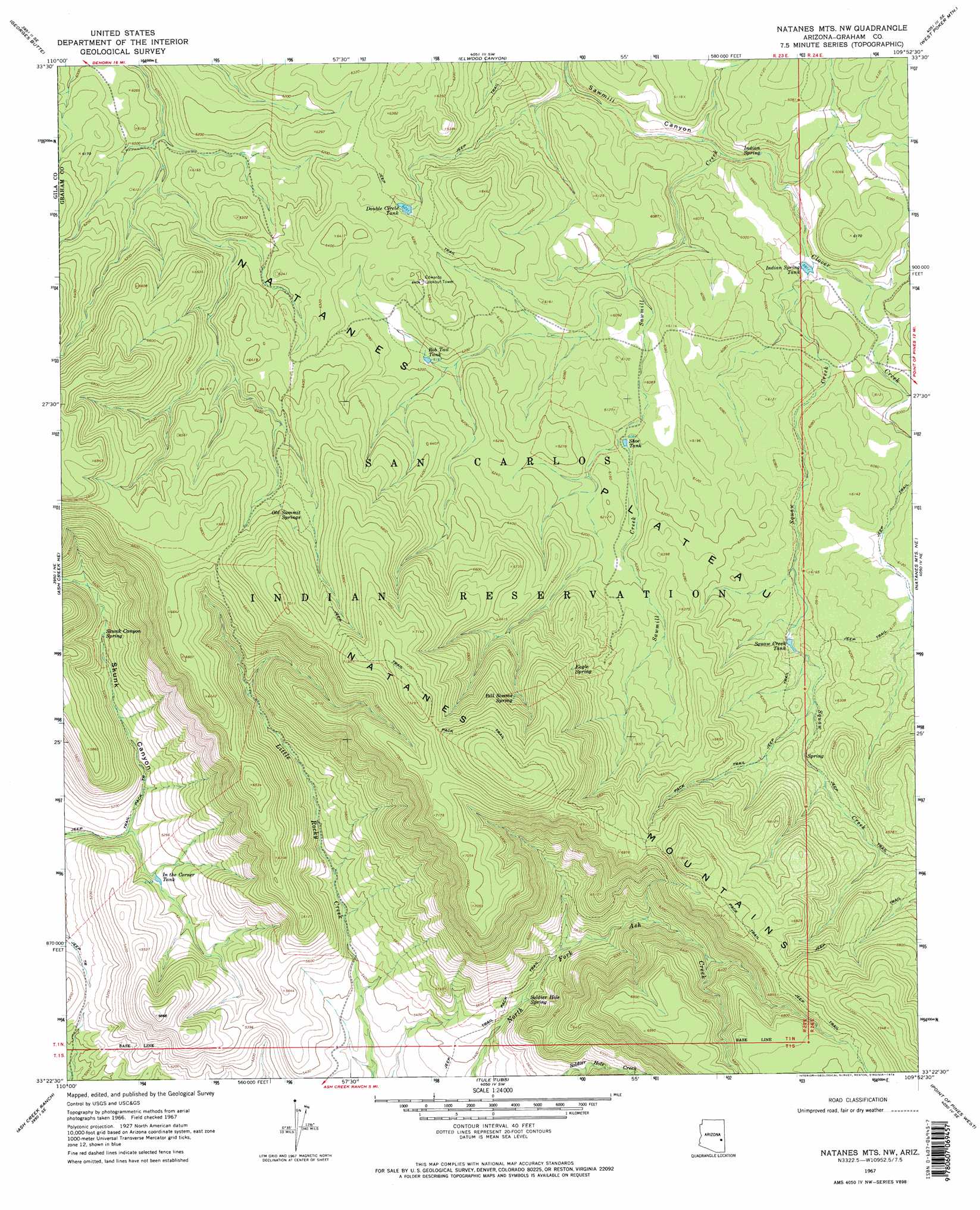
USGS Topo Quad 33109d8 - 1:24,000 scale
| Topo Map Name: | Natanes Mountains Nw |
| USGS Topo Quad ID: | 33109d8 |
| Print Size: | ca. 21 1/4" wide x 27" high |
| Southeast Coordinates: | 33.375° N latitude / 109.875° W longitude |
| Map Center Coordinates: | 33.4375° N latitude / 109.9375° W longitude |
| U.S. State: | AZ |
| Filename: | o33109d8.jpg |
| Download Map JPG Image: | Natanes Mountains Nw topo map 1:24,000 scale |
| Map Type: | Topographic |
| Topo Series: | 7.5´ |
| Map Scale: | 1:24,000 |
| Source of Map Images: | United States Geological Survey (USGS) |
| Alternate Map Versions: |
Natanes Mts NW AZ 1967, updated 1971 Download PDF Buy paper map Natanes Mts NW AZ 1967, updated 1974 Download PDF Buy paper map Natanes Mts NW AZ 1967, updated 1974 Download PDF Buy paper map Natanes Mountains NW AZ 2011 Download PDF Buy paper map Natanes Mountains NW AZ 2014 Download PDF Buy paper map |
1:24,000 Topo Quads surrounding Natanes Mountains Nw
Forks Butte |
Velasquez Butte |
Bonito Prairie |
Corn Creek |
Odart Mountain |
Chiricahua Butte |
Georges Butte |
Elwood Canyon |
West Poker Mountain |
Maverick Sw |
Bronco Gulch |
Ash Creek Ne |
Natanes Mountains Nw |
Natanes Mountains Ne |
Sawbuck Mountain |
Branaman Spring |
Ash Creek Ranch |
Tule Tubs |
Point Of Pines West |
Point Of Pines East |
Calva |
Bylas |
Gila Peak |
Bonita Tank |
Park Creek Cabins |
> Back to 33109a1 at 1:100,000 scale
> Back to 33108a1 at 1:250,000 scale
> Back to U.S. Topo Maps home
Natanes Mountains Nw topo map: Gazetteer
Natanes Mountains Nw: Ranges
Natanes Mountains elevation 2187m 7175′Natanes Mountains Nw: Reservoirs
Bob Tail Tank elevation 1880m 6167′Double Circle Tank elevation 1899m 6230′
In the Corner Tank elevation 1567m 5141′
Indian Spring Tank elevation 1803m 5915′
Shoe Tank elevation 0m 0′
Squaw Creek Tank elevation 1865m 6118′
Natanes Mountains Nw: Springs
Bill Simms Spring elevation 2094m 6870′Eagle Spring elevation 2026m 6646′
Indian Spring elevation 1789m 5869′
Old Summit Springs elevation 2017m 6617′
Skunk Canyon Spring elevation 1652m 5419′
Soldier Hole Spring elevation 1682m 5518′
Natanes Mountains Nw: Streams
Clover Creek elevation 1779m 5836′Soldier Hole Creek elevation 1718m 5636′
Squaw Creek elevation 1802m 5912′
Natanes Mountains Nw: Valleys
Skunk Canyon elevation 1544m 5065′Natanes Mountains Nw digital topo map on disk
Buy this Natanes Mountains Nw topo map showing relief, roads, GPS coordinates and other geographical features, as a high-resolution digital map file on DVD: