Bear Mountain Topo Map Arizona
To zoom in, hover over the map of Bear Mountain
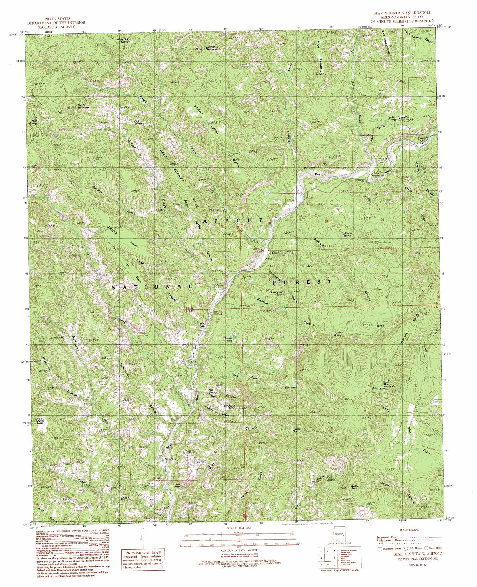
USGS Topo Quad 33109e2 - 1:24,000 scale
| Topo Map Name: | Bear Mountain |
| USGS Topo Quad ID: | 33109e2 |
| Print Size: | ca. 21 1/4" wide x 27" high |
| Southeast Coordinates: | 33.5° N latitude / 109.125° W longitude |
| Map Center Coordinates: | 33.5625° N latitude / 109.1875° W longitude |
| U.S. State: | AZ |
| Filename: | o33109e2.jpg |
| Download Map JPG Image: | Bear Mountain topo map 1:24,000 scale |
| Map Type: | Topographic |
| Topo Series: | 7.5´ |
| Map Scale: | 1:24,000 |
| Source of Map Images: | United States Geological Survey (USGS) |
| Alternate Map Versions: |
Bear Mountain AZ 1991, updated 1991 Download PDF Buy paper map Bear Mountain AZ 1997, updated 2000 Download PDF Buy paper map Bear Mountain AZ 2011 Download PDF Buy paper map Bear Mountain AZ 2014 Download PDF Buy paper map |
| FStopo: | US Forest Service topo Bear Mountain is available: Download FStopo PDF Download FStopo TIF |
1:24,000 Topo Quads surrounding Bear Mountain
Big Lake South |
Buffalo Crossing |
Alpine |
Luna Lake |
Luna |
Hoodoo Knob |
Hannagan Meadow |
Beaverhead |
Maness Peak |
Bull Basin |
Baldy Bill Point |
Strayhorse |
Bear Mountain |
Blue |
Saliz Pass |
Robinson Mesa |
Rose Peak |
Dutch Blue Creek |
Alma Mesa |
Alma |
Bee Canyon |
Pipestem Mountain |
Fritz Canyon |
Maple Peak |
Glenwood |
> Back to 33109e1 at 1:100,000 scale
> Back to 33108a1 at 1:250,000 scale
> Back to U.S. Topo Maps home
Bear Mountain topo map: Gazetteer
Bear Mountain: Basins
The Box elevation 1628m 5341′Bear Mountain: Cliffs
Turtle Rock elevation 1716m 5629′Bear Mountain: Crossings
Balke Crossing elevation 1696m 5564′Bear Mountain: Flats
Cole Flat elevation 1602m 5255′Bear Mountain: Gaps
Red Saddles elevation 2008m 6587′Bear Mountain: Lakes
Thomas Lake elevation 1764m 5787′Bear Mountain: Parks
Blue Range Primitive Area elevation 1816m 5958′Bear Mountain: Pillars
Ice Cream Cone elevation 2007m 6584′Bear Mountain: Post Offices
Blue Post Office elevation 1657m 5436′Bear Mountain: Ridges
Dead Juniper Ridge elevation 2052m 6732′Telephone Ridge elevation 2394m 7854′
Bear Mountain: Springs
A Spring elevation 2183m 7162′A Spring elevation 2157m 7076′
Bear Spring elevation 2143m 7030′
Cedar Spring elevation 1843m 6046′
Grasshopper Spring elevation 1801m 5908′
Mangrum Spring elevation 2217m 7273′
Mud Spring elevation 2088m 6850′
Owl Spring elevation 2008m 6587′
Stevens Spring elevation 1774m 5820′
Still Spring elevation 1708m 5603′
Sweetie Spring elevation 2128m 6981′
White Oak Spring elevation 2226m 7303′
Bear Mountain: Streams
Fishhook Creek elevation 1677m 5501′Foote Creek elevation 1690m 5544′
Grant Creek elevation 1653m 5423′
KP Creek elevation 1569m 5147′
Largo Creek elevation 1706m 5597′
McKittrick Creek elevation 1543m 5062′
Panther Creek elevation 1754m 5754′
Raspberry Creek elevation 1531m 5022′
Steeple Creek elevation 1632m 5354′
Bear Mountain: Summits
Auger Peak elevation 2337m 7667′Bear Mountain elevation 2612m 8569′
Fishhook Mesa elevation 2094m 6870′
Foote Creek Mesa elevation 2094m 6870′
Grant Creek Mesa elevation 2135m 7004′
Grant Creek Mesa elevation 2109m 6919′
KP Mesa elevation 2046m 6712′
Muhly Mountain elevation 2264m 7427′
Muhly Mountain elevation 2239m 7345′
Steeple Mesa elevation 2073m 6801′
Waynick Mountain elevation 2280m 7480′
Bear Mountain: Trails
Steeple Mesa Seventy-Three Trail elevation 2148m 7047′Bear Mountain: Valleys
Barnes Canyon elevation 1598m 5242′Bear Canyon elevation 1543m 5062′
Cedar Springs Canyon elevation 1710m 5610′
Dead Juniper Canyon elevation 1658m 5439′
Diaper Wash elevation 1666m 5465′
Grapevine Canyon elevation 1671m 5482′
Grasshopper Canyon elevation 1668m 5472′
Horse Canyon elevation 1617m 5305′
Lanphier Canyon elevation 1716m 5629′
Moonshine Canyon elevation 1554m 5098′
Red Bull Canyon elevation 1593m 5226′
Sawmill Canyon elevation 1664m 5459′
Still Canyon elevation 1580m 5183′
Sweetie Canyon elevation 1661m 5449′
Bear Mountain digital topo map on disk
Buy this Bear Mountain topo map showing relief, roads, GPS coordinates and other geographical features, as a high-resolution digital map file on DVD: