Maverick Topo Map Arizona
To zoom in, hover over the map of Maverick
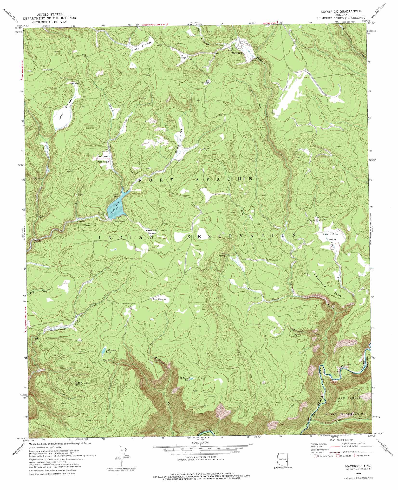
USGS Topo Quad 33109f5 - 1:24,000 scale
| Topo Map Name: | Maverick |
| USGS Topo Quad ID: | 33109f5 |
| Print Size: | ca. 21 1/4" wide x 27" high |
| Southeast Coordinates: | 33.625° N latitude / 109.5° W longitude |
| Map Center Coordinates: | 33.6875° N latitude / 109.5625° W longitude |
| U.S. State: | AZ |
| Filename: | o33109f5.jpg |
| Download Map JPG Image: | Maverick topo map 1:24,000 scale |
| Map Type: | Topographic |
| Topo Series: | 7.5´ |
| Map Scale: | 1:24,000 |
| Source of Map Images: | United States Geological Survey (USGS) |
| Alternate Map Versions: |
Maverick AZ 1967, updated 1971 Download PDF Buy paper map Maverick AZ 1978, updated 1978 Download PDF Buy paper map Maverick AZ 2011 Download PDF Buy paper map Maverick AZ 2014 Download PDF Buy paper map |
1:24,000 Topo Quads surrounding Maverick
Hawley Lake West |
Hawley Lake East |
Mount Baldy |
Big Lake North |
Rudd Knoll |
Corn Creek Plateau |
Marshall Butte |
Bonito Rock |
Big Lake South |
Buffalo Crossing |
Corn Creek |
Odart Mountain |
Maverick |
Hoodoo Knob |
Hannagan Meadow |
West Poker Mountain |
Maverick Sw |
Freezeout Mountain |
Baldy Bill Point |
Strayhorse |
Natanes Mountains Ne |
Sawbuck Mountain |
Willow Mountain |
Robinson Mesa |
Rose Peak |
> Back to 33109e1 at 1:100,000 scale
> Back to 33108a1 at 1:250,000 scale
> Back to U.S. Topo Maps home
Maverick topo map: Gazetteer
Maverick: Cliffs
Rattlesnake Point elevation 2230m 7316′Maverick: Dams
Tonto Dam elevation 2347m 7700′Maverick: Flats
Bee Cienega elevation 2353m 7719′Elk Cienega elevation 2445m 8021′
Hawks Nest Cienega elevation 2370m 7775′
Odart Cienega elevation 2424m 7952′
Paddy Cienega elevation 2297m 7536′
Pair o'Dice Cienega elevation 2229m 7312′
Pat Cienega elevation 2460m 8070′
Sheep Cienega elevation 0m 0′
Willow Cienega elevation 2375m 7791′
Y Cienega elevation 2431m 7975′
Maverick: Populated Places
Maverick elevation 2379m 7805′Maverick: Reservoirs
Battleground Number One Tank elevation 2227m 7306′McDonald Tank elevation 2308m 7572′
Salt House Tank elevation 0m 0′
Tonto Lake elevation 2347m 7700′
Maverick: Springs
Ess Spring elevation 2273m 7457′Maverick: Streams
Battleground Creek elevation 2058m 6751′Bear Creek elevation 1995m 6545′
Bear Wallow Creek elevation 1960m 6430′
Bluff Cienega Creek elevation 2371m 7778′
Ess Creek elevation 2200m 7217′
Milk Creek elevation 2057m 6748′
Pacheta Creek elevation 1974m 6476′
Spud Creek elevation 2217m 7273′
Maverick: Summits
Paddy Butte elevation 2442m 8011′Maverick digital topo map on disk
Buy this Maverick topo map showing relief, roads, GPS coordinates and other geographical features, as a high-resolution digital map file on DVD: