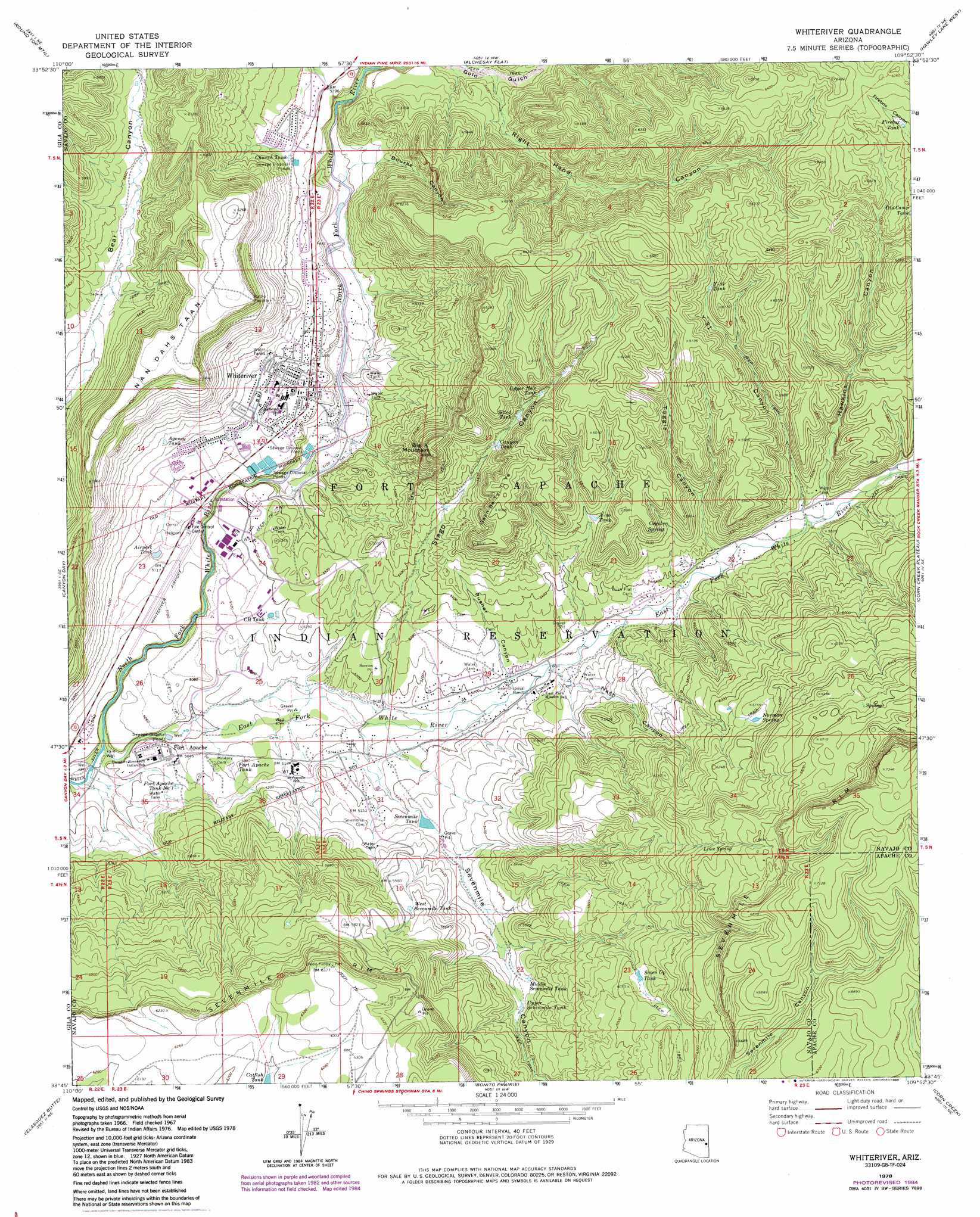
Whiteriver Topo Map Arizona
To zoom in, hover over the map of Whiteriver
USGS Topo Quad 33109g8 - 1:24,000 scale
| Topo Map Name: | Whiteriver |
| USGS Topo Quad ID: | 33109g8 |
| Print Size: | ca. 21 1/4" wide x 27" high |
| Southeast Coordinates: | 33.75° N latitude / 109.875° W longitude |
| Map Center Coordinates: | 33.8125° N latitude / 109.9375° W longitude |
| U.S. State: | AZ |
| Filename: | o33109g8.jpg |
| Download Map JPG Image: | Whiteriver topo map 1:24,000 scale |
| Map Type: | Topographic |
| Topo Series: | 7.5´ |
| Map Scale: | 1:24,000 |
| Source of Map Images: | United States Geological Survey (USGS) |
| Alternate Map Versions: |
Whiteriver AZ 1967, updated 1971 Download PDF Buy paper map Whiteriver AZ 1978, updated 1985 Download PDF Buy paper map Whiteriver AZ 2011 Download PDF Buy paper map Whiteriver AZ 2014 Download PDF Buy paper map |
1:24,000 Topo Quads surrounding Whiteriver
Long Tom Canyon |
Faught Ridge |
Indian Pine |
Mcnary |
Horseshoe Cienega |
Cedar Creek |
Round Top Mountain |
Alchesay Flat |
Hawley Lake West |
Hawley Lake East |
Cone Butte |
Canyon Day |
Whiteriver |
Corn Creek Plateau |
Marshall Butte |
Forks Butte |
Velasquez Butte |
Bonito Prairie |
Corn Creek |
Odart Mountain |
Chiricahua Butte |
Georges Butte |
Elwood Canyon |
West Poker Mountain |
Maverick Sw |
> Back to 33109e1 at 1:100,000 scale
> Back to 33108a1 at 1:250,000 scale
> Back to U.S. Topo Maps home
Whiteriver topo map: Gazetteer
Whiteriver: Airports
Whiteriver Airport elevation 1559m 5114′Whiteriver: Cliffs
Sevenmile Rim elevation 0m 0′Whiteriver: Dams
Sevenmile Tank Dam elevation 1602m 5255′Whiteriver: Populated Places
East Fork elevation 1601m 5252′Fort Apache elevation 1541m 5055′
Sevenmile elevation 1584m 5196′
Whiteriver elevation 1599m 5246′
Whiteriver: Post Offices
Fort Apache Post Office elevation 1542m 5059′Whiteriver Post Office elevation 1592m 5223′
Whiteriver: Reservoirs
A-eighty Tank elevation 1701m 5580′Agency Tank elevation 1615m 5298′
Airport Tank elevation 1564m 5131′
Canyon Tank elevation 1724m 5656′
CH Tank elevation 1579m 5180′
Church Tank elevation 1647m 5403′
Firebox Tank elevation 1887m 6190′
Fort Apache Tank elevation 1546m 5072′
Fort Apache Tank Number One elevation 1551m 5088′
Middle Sevenmile Tank elevation 1668m 5472′
Old Camp Tank elevation 1849m 6066′
Seven Up Tank elevation 0m 0′
Sevenmile Tank elevation 0m 0′
Silted Tank elevation 0m 0′
Upper Hole Tank elevation 1766m 5793′
Upper Sevenmile Tank elevation 1667m 5469′
West Sevenmile Tank elevation 1706m 5597′
Whitespot Tank elevation 1743m 5718′
Y-thirtyone Tank elevation 1825m 5987′
Whiteriver: Springs
Coyote Spring elevation 1708m 5603′Lime Spring elevation 1914m 6279′
Norman Spring elevation 1864m 6115′
Whiteriver: Streams
East Fork White River elevation 1497m 4911′North Fork White River elevation 1497m 4911′
Whiteriver: Summits
Big A Mountain elevation 1837m 6026′Gaan Be Ti Ye Mesa elevation 1858m 6095′
Nan Dahs Taan Mesa elevation 1907m 6256′
Whiteriver: Valleys
Bourke Canyon elevation 1617m 5305′Hawkins Canyon elevation 1668m 5472′
Nash Canyon elevation 1597m 5239′
Pusher Canyon elevation 1596m 5236′
Right Hand Canyon elevation 1633m 5357′
Sevenmile Canyon elevation 0m 0′
Stago Canyon elevation 1567m 5141′
Toggie Canyon elevation 1645m 5396′
Y-thirtyone Canyon elevation 1668m 5472′
Whiteriver digital topo map on disk
Buy this Whiteriver topo map showing relief, roads, GPS coordinates and other geographical features, as a high-resolution digital map file on DVD: