Hawley Lake West Topo Map Arizona
To zoom in, hover over the map of Hawley Lake West
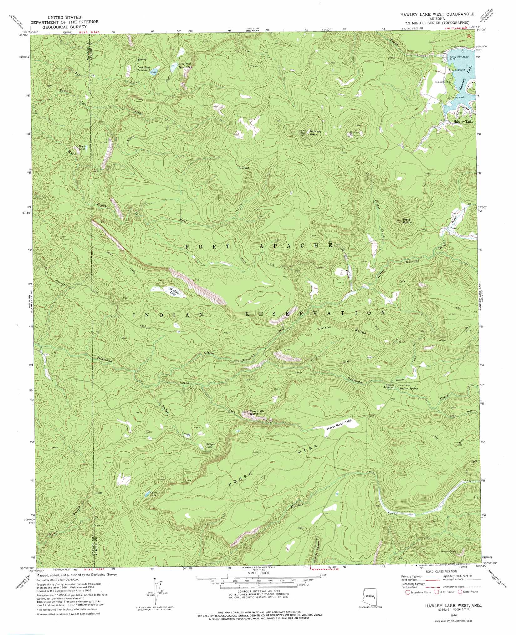
USGS Topo Quad 33109h7 - 1:24,000 scale
| Topo Map Name: | Hawley Lake West |
| USGS Topo Quad ID: | 33109h7 |
| Print Size: | ca. 21 1/4" wide x 27" high |
| Southeast Coordinates: | 33.875° N latitude / 109.75° W longitude |
| Map Center Coordinates: | 33.9375° N latitude / 109.8125° W longitude |
| U.S. State: | AZ |
| Filename: | o33109h7.jpg |
| Download Map JPG Image: | Hawley Lake West topo map 1:24,000 scale |
| Map Type: | Topographic |
| Topo Series: | 7.5´ |
| Map Scale: | 1:24,000 |
| Source of Map Images: | United States Geological Survey (USGS) |
| Alternate Map Versions: |
Hawley Lake West AZ 1966, updated 1971 Download PDF Buy paper map Hawley Lake West AZ 1976, updated 1977 Download PDF Buy paper map Hawley Lake West AZ 2011 Download PDF Buy paper map Hawley Lake West AZ 2014 Download PDF Buy paper map |
1:24,000 Topo Quads surrounding Hawley Lake West
Show Low South |
Lakeside |
Sponseller Mountain |
Boundary Butte |
Whiting Knoll |
Faught Ridge |
Indian Pine |
Mcnary |
Horseshoe Cienega |
Greens Peak |
Round Top Mountain |
Alchesay Flat |
Hawley Lake West |
Hawley Lake East |
Mount Baldy |
Canyon Day |
Whiteriver |
Corn Creek Plateau |
Marshall Butte |
Bonito Rock |
Velasquez Butte |
Bonito Prairie |
Corn Creek |
Odart Mountain |
Maverick |
> Back to 33109e1 at 1:100,000 scale
> Back to 33108a1 at 1:250,000 scale
> Back to U.S. Topo Maps home
Hawley Lake West topo map: Gazetteer
Hawley Lake West: Basins
Horse Mesa Trap elevation 2360m 7742′Hawley Lake West: Dams
Christmas Tree Dam elevation 2401m 7877′Davis Dam elevation 2489m 8166′
Hawley Lake West: Lakes
Cover Lake elevation 2251m 7385′Duck Lake elevation 2151m 7057′
Hawley Lake West: Parks
Diamond Creek Campsite Number Three elevation 2365m 7759′Hawley Lake Campground Area elevation 2501m 8205′
Hawley Lake West: Populated Places
Kinney Junction elevation 2355m 7726′Hawley Lake West: Post Offices
Hawley Lake Post Office elevation 2509m 8231′Hawley Lake West: Reservoirs
Hawley Lake elevation 2489m 8166′Lone Pine Tank Number One elevation 2287m 7503′
Lone Pine Tank Number Two elevation 2228m 7309′
Hawley Lake West: Ridges
Walton Ridge elevation 2443m 8015′Hawley Lake West: Springs
Walton Spring elevation 2353m 7719′Hawley Lake West: Streams
Badger Creek elevation 1962m 6437′Cienega Creek elevation 2254m 7395′
Coon Creek elevation 2040m 6692′
Coyote Creek elevation 2362m 7749′
Little Diamond Creek elevation 1972m 6469′
Pistol Creek elevation 2286m 7500′
Walton Creek elevation 2339m 7673′
Hawley Lake West: Summits
Horse Mesa elevation 2404m 7887′McKays Peak elevation 2791m 9156′
Pistol Butte elevation 2540m 8333′
Tsay O Ah Butte elevation 2363m 7752′
Hawley Lake West: Swamps
Badger Lake elevation 2168m 7112′Woolsey Lake elevation 2152m 7060′
Hawley Lake West digital topo map on disk
Buy this Hawley Lake West topo map showing relief, roads, GPS coordinates and other geographical features, as a high-resolution digital map file on DVD: