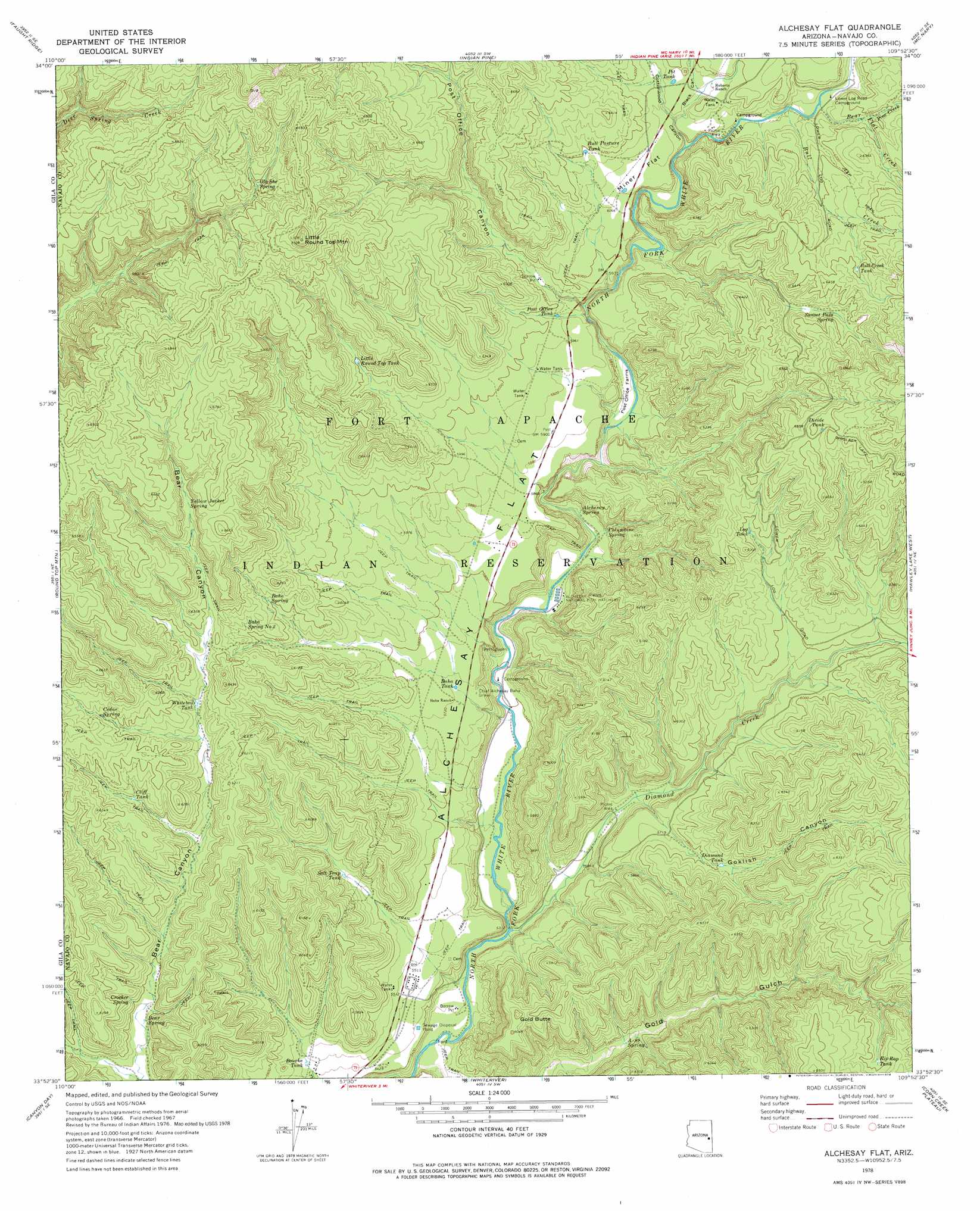
Alchesay Flat Topo Map Arizona
To zoom in, hover over the map of Alchesay Flat
USGS Topo Quad 33109h8 - 1:24,000 scale
| Topo Map Name: | Alchesay Flat |
| USGS Topo Quad ID: | 33109h8 |
| Print Size: | ca. 21 1/4" wide x 27" high |
| Southeast Coordinates: | 33.875° N latitude / 109.875° W longitude |
| Map Center Coordinates: | 33.9375° N latitude / 109.9375° W longitude |
| U.S. State: | AZ |
| Filename: | o33109h8.jpg |
| Download Map JPG Image: | Alchesay Flat topo map 1:24,000 scale |
| Map Type: | Topographic |
| Topo Series: | 7.5´ |
| Map Scale: | 1:24,000 |
| Source of Map Images: | United States Geological Survey (USGS) |
| Alternate Map Versions: |
Alchesay Flat AZ 1967, updated 1971 Download PDF Buy paper map Alchesay Flat AZ 2011 Download PDF Buy paper map Alchesay Flat AZ 2014 Download PDF Buy paper map |
1:24,000 Topo Quads surrounding Alchesay Flat
Red Top Mountain |
Show Low South |
Lakeside |
Sponseller Mountain |
Boundary Butte |
Long Tom Canyon |
Faught Ridge |
Indian Pine |
Mcnary |
Horseshoe Cienega |
Cedar Creek |
Round Top Mountain |
Alchesay Flat |
Hawley Lake West |
Hawley Lake East |
Cone Butte |
Canyon Day |
Whiteriver |
Corn Creek Plateau |
Marshall Butte |
Forks Butte |
Velasquez Butte |
Bonito Prairie |
Corn Creek |
Odart Mountain |
> Back to 33109e1 at 1:100,000 scale
> Back to 33108a1 at 1:250,000 scale
> Back to U.S. Topo Maps home
Alchesay Flat topo map: Gazetteer
Alchesay Flat: Arroyos
Round Top Wash elevation 1703m 5587′Alchesay Flat: Bends
Post Office Farms elevation 1759m 5770′Alchesay Flat: Dams
Baha Diversion Dam elevation 1643m 5390′Kaytoggie Diversion Dam elevation 1649m 5410′
Alchesay Flat: Flats
Alchesay Flat elevation 1760m 5774′Miner Flat elevation 1856m 6089′
Alchesay Flat: Reservoirs
Alchesay Tank elevation 1691m 5547′Baha Tank elevation 1742m 5715′
Bourke Tank elevation 1668m 5472′
Bull Creek Tank elevation 1949m 6394′
Bull Pasture Tank elevation 1892m 6207′
Cliff Tank elevation 1849m 6066′
Diamond Tank elevation 1771m 5810′
Divide Tank elevation 1999m 6558′
Holding Pasture Tank elevation 1855m 6085′
Little Round Top Tank elevation 1893m 6210′
Log Tank elevation 1877m 6158′
Pit Tank elevation 1877m 6158′
Post Office Tank elevation 1814m 5951′
Rip Rap Tank elevation 1882m 6174′
Salt Trap Tank elevation 0m 0′
Sunset Pass Tank elevation 1899m 6230′
Whitetail Tank elevation 1853m 6079′
Alchesay Flat: Springs
A-ninetyone Spring elevation 1691m 5547′Baha Spring elevation 1838m 6030′
Baha Spring Number Two elevation 1854m 6082′
Bear Spring elevation 1751m 5744′
Cedar Spring elevation 1904m 6246′
Columbine Spring elevation 1693m 5554′
Crocker Spring elevation 1780m 5839′
Gla She Spring elevation 1998m 6555′
Sunset Pass Spring elevation 1922m 6305′
Yellow Jacket Spring elevation 1932m 6338′
Alchesay Flat: Streams
Bear Flat Creek elevation 1848m 6062′Bull Creek elevation 1838m 6030′
Diamond Creek elevation 1616m 5301′
Pine Creek elevation 1873m 6145′
Alchesay Flat: Summits
Gold Butte elevation 1839m 6033′Little Round Top Mountain elevation 2159m 7083′
Alchesay Flat: Valleys
Black Canyon elevation 1835m 6020′Cottonwood Canyon elevation 1833m 6013′
Goklish Canyon elevation 1678m 5505′
Gold Gulch elevation 1606m 5269′
Post Office Canyon elevation 1795m 5889′
Alchesay Flat digital topo map on disk
Buy this Alchesay Flat topo map showing relief, roads, GPS coordinates and other geographical features, as a high-resolution digital map file on DVD: