San Carlos Topo Map Arizona
To zoom in, hover over the map of San Carlos
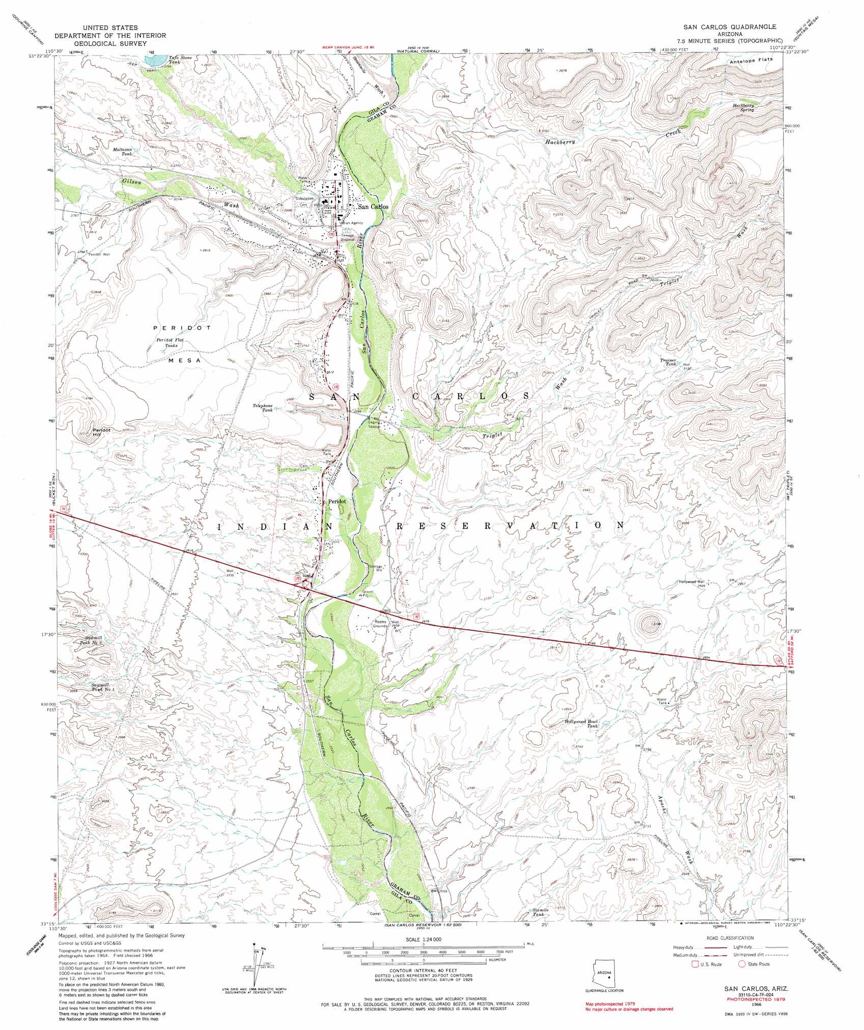
USGS Topo Quad 33110c4 - 1:24,000 scale
| Topo Map Name: | San Carlos |
| USGS Topo Quad ID: | 33110c4 |
| Print Size: | ca. 21 1/4" wide x 27" high |
| Southeast Coordinates: | 33.25° N latitude / 110.375° W longitude |
| Map Center Coordinates: | 33.3125° N latitude / 110.4375° W longitude |
| U.S. State: | AZ |
| Filename: | o33110c4.jpg |
| Download Map JPG Image: | San Carlos topo map 1:24,000 scale |
| Map Type: | Topographic |
| Topo Series: | 7.5´ |
| Map Scale: | 1:24,000 |
| Source of Map Images: | United States Geological Survey (USGS) |
| Alternate Map Versions: |
San Carlos AZ 1966, updated 1968 Download PDF Buy paper map San Carlos AZ 1966, updated 1985 Download PDF Buy paper map San Carlos AZ 2011 Download PDF Buy paper map San Carlos AZ 2014 Download PDF Buy paper map |
1:24,000 Topo Quads surrounding San Carlos
Chrome Butte |
Sevenmile Mountains |
Cassadore Spring |
Sontag Creek |
Chiricahua Butte |
Cammerman Wash |
Dourine Canyon |
Natural Corral |
Sontag Mesa |
Bronco Gulch |
Cutter |
Bucket Mountain |
San Carlos |
Mount Triplet |
Branaman Spring |
Mescal Warm Spring |
Coolidge Dam |
San Carlos Reservoir |
Dewey Flat |
Calva |
Christmas |
Jerusalem Mountain |
Rawhide Mountain |
Mount Turnbull |
Beargrass Basin |
> Back to 33110a1 at 1:100,000 scale
> Back to 33110a1 at 1:250,000 scale
> Back to U.S. Topo Maps home
San Carlos topo map: Gazetteer
San Carlos: Dams
Naltazen Dam elevation 842m 2762′Trainer Dam elevation 1001m 3284′
Tufa Stone Dam elevation 839m 2752′
San Carlos: Flats
Peridot Mesa elevation 904m 2965′San Carlos: Populated Places
Peridot elevation 800m 2624′San Carlos elevation 0m 0′
San Carlos: Post Offices
Peridot Post Office elevation 793m 2601′San Carlos Post Office elevation 805m 2641′
San Carlos: Reservoirs
Hollywood Bowl Tank elevation 830m 2723′Maltazan Tank elevation 842m 2762′
Peridot Flat Tanks elevation 902m 2959′
Sawmill Tank Number One elevation 0m 0′
Sawmill Tank Number Two elevation 0m 0′
Sixmile Tank elevation 800m 2624′
Telephone Tank elevation 886m 2906′
Trainer Tank elevation 956m 3136′
Tufa Stone Tank elevation 842m 2762′
San Carlos: Springs
Hackberry Spring elevation 949m 3113′San Carlos: Streams
Gilson Wash elevation 798m 2618′Hackberry Creek elevation 811m 2660′
Sevenmile Wash elevation 811m 2660′
Triplet Wash elevation 793m 2601′
San Carlos: Summits
Peridot Hill elevation 981m 3218′San Carlos: Wells
Hollywood Well elevation 891m 2923′Peridot Well elevation 853m 2798′
San Carlos digital topo map on disk
Buy this San Carlos topo map showing relief, roads, GPS coordinates and other geographical features, as a high-resolution digital map file on DVD: