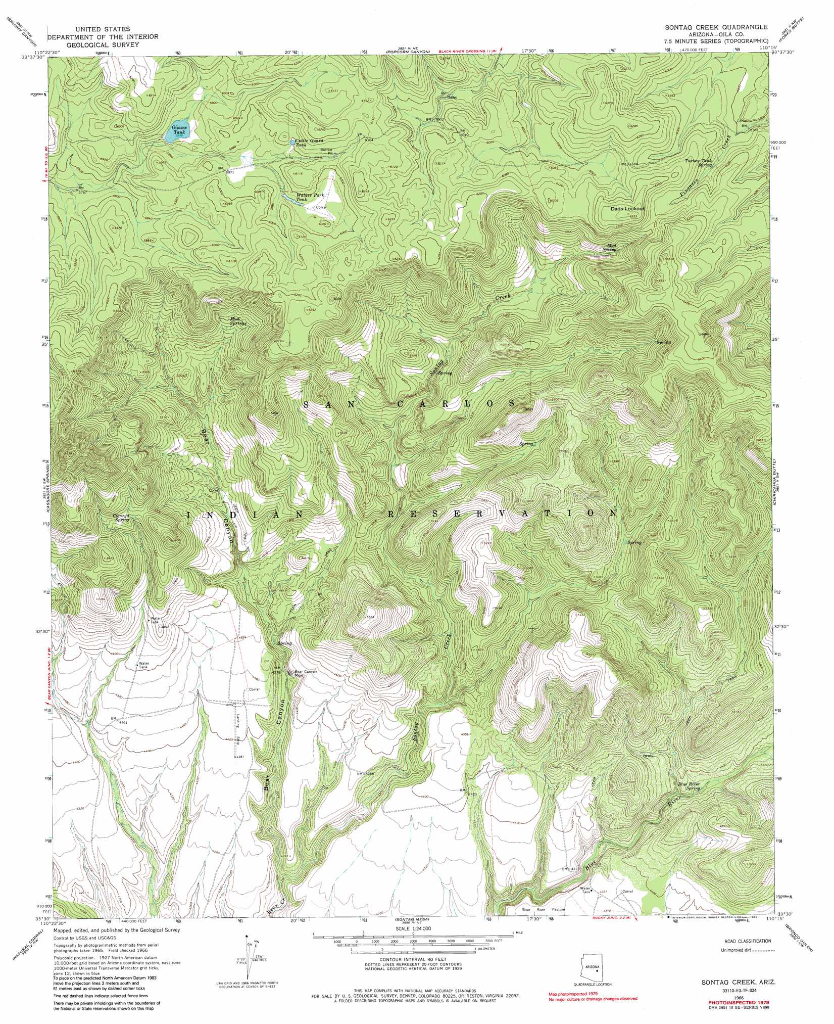
Sontag Creek Topo Map Arizona
To zoom in, hover over the map of Sontag Creek
USGS Topo Quad 33110e3 - 1:24,000 scale
| Topo Map Name: | Sontag Creek |
| USGS Topo Quad ID: | 33110e3 |
| Print Size: | ca. 21 1/4" wide x 27" high |
| Southeast Coordinates: | 33.5° N latitude / 110.25° W longitude |
| Map Center Coordinates: | 33.5625° N latitude / 110.3125° W longitude |
| U.S. State: | AZ |
| Filename: | o33110e3.jpg |
| Download Map JPG Image: | Sontag Creek topo map 1:24,000 scale |
| Map Type: | Topographic |
| Topo Series: | 7.5´ |
| Map Scale: | 1:24,000 |
| Source of Map Images: | United States Geological Survey (USGS) |
| Alternate Map Versions: |
Sontag Creek AZ 1966, updated 1968 Download PDF Buy paper map Sontag Creek AZ 1966, updated 1985 Download PDF Buy paper map Sontag Creek AZ 2011 Download PDF Buy paper map Sontag Creek AZ 2014 Download PDF Buy paper map |
1:24,000 Topo Quads surrounding Sontag Creek
Mule Hoof Bend |
Beckers Butte |
Carrizo Se |
Cone Butte |
Canyon Day |
Chrysotile |
Brushy Canyon |
Popcorn Canyon |
Forks Butte |
Velasquez Butte |
Sevenmile Mountains |
Cassadore Spring |
Sontag Creek |
Chiricahua Butte |
Georges Butte |
Dourine Canyon |
Natural Corral |
Sontag Mesa |
Bronco Gulch |
Ash Creek Ne |
Bucket Mountain |
San Carlos |
Mount Triplet |
Branaman Spring |
Ash Creek Ranch |
> Back to 33110e1 at 1:100,000 scale
> Back to 33110a1 at 1:250,000 scale
> Back to U.S. Topo Maps home
Sontag Creek topo map: Gazetteer
Sontag Creek: Mines
Bear Canyon Mine elevation 1322m 4337′Sontag Creek: Reservoirs
Cattle Guard Tank elevation 1828m 5997′Gimme Tank elevation 1787m 5862′
Walker Park Tank elevation 1817m 5961′
Sontag Creek: Springs
Blue River Spring elevation 1305m 4281′Cienega Spring elevation 1602m 5255′
Mud Spring elevation 1732m 5682′
Mud Springs elevation 1616m 5301′
Turkey Tank Spring elevation 1792m 5879′
White Tail Spring elevation 1526m 5006′
Sontag Creek: Streams
Sontag Creek elevation 1218m 3996′Sontag Creek: Summits
Dads Lookout elevation 1930m 6332′Sontag Creek: Valleys
Bear Canyon elevation 1217m 3992′Sontag Creek digital topo map on disk
Buy this Sontag Creek topo map showing relief, roads, GPS coordinates and other geographical features, as a high-resolution digital map file on DVD: