Round Top Mountain Topo Map Arizona
To zoom in, hover over the map of Round Top Mountain
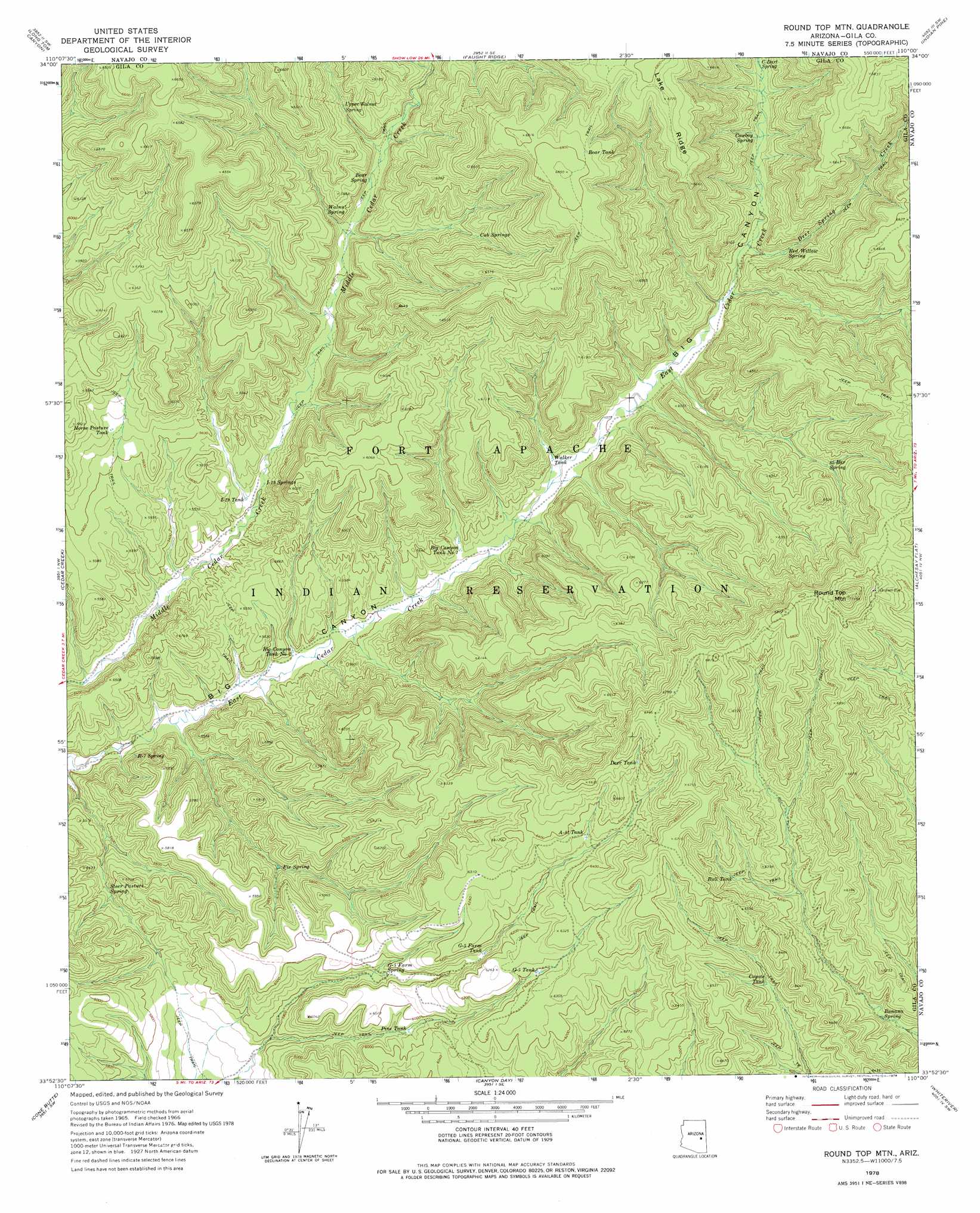
USGS Topo Quad 33110h1 - 1:24,000 scale
| Topo Map Name: | Round Top Mountain |
| USGS Topo Quad ID: | 33110h1 |
| Print Size: | ca. 21 1/4" wide x 27" high |
| Southeast Coordinates: | 33.875° N latitude / 110° W longitude |
| Map Center Coordinates: | 33.9375° N latitude / 110.0625° W longitude |
| U.S. State: | AZ |
| Filename: | o33110h1.jpg |
| Download Map JPG Image: | Round Top Mountain topo map 1:24,000 scale |
| Map Type: | Topographic |
| Topo Series: | 7.5´ |
| Map Scale: | 1:24,000 |
| Source of Map Images: | United States Geological Survey (USGS) |
| Alternate Map Versions: |
Round Top Mtn AZ 1966, updated 1967 Download PDF Buy paper map Round Top Mountain AZ 2011 Download PDF Buy paper map Round Top Mountain AZ 2014 Download PDF Buy paper map |
1:24,000 Topo Quads surrounding Round Top Mountain
Limestone Canyon North |
Red Top Mountain |
Show Low South |
Lakeside |
Sponseller Mountain |
Limestone Canyon South |
Long Tom Canyon |
Faught Ridge |
Indian Pine |
Mcnary |
Carrizo |
Cedar Creek |
Round Top Mountain |
Alchesay Flat |
Hawley Lake West |
Carrizo Se |
Cone Butte |
Canyon Day |
Whiteriver |
Corn Creek Plateau |
Popcorn Canyon |
Forks Butte |
Velasquez Butte |
Bonito Prairie |
Corn Creek |
> Back to 33110e1 at 1:100,000 scale
> Back to 33110a1 at 1:250,000 scale
> Back to U.S. Topo Maps home
Round Top Mountain topo map: Gazetteer
Round Top Mountain: Reservoirs
A-eightyone Tank elevation 1923m 6309′Bear Tank elevation 2064m 6771′
Big Canyon Tank Number One elevation 1680m 5511′
Big Canyon Tank Number Two elevation 1632m 5354′
Bull Tank elevation 1898m 6227′
Coyote Tank elevation 1874m 6148′
Deer Tank elevation 1986m 6515′
G-five Farm Tank elevation 1851m 6072′
G-five Tank elevation 1890m 6200′
Horse Pasture Tank elevation 1725m 5659′
I-nineteen Tank elevation 1658m 5439′
Pine Tank elevation 1815m 5954′
Walker Tank elevation 1701m 5580′
Round Top Mountain: Springs
Banana Spring elevation 1778m 5833′Bear Spring elevation 1735m 5692′
C-Dart Spring elevation 1801m 5908′
Cowboy Spring elevation 1800m 5905′
Cub Springs elevation 1837m 6026′
Eightyfive Bar Spring elevation 1851m 6072′
Fir Spring elevation 1705m 5593′
G-five Farm Spring elevation 1804m 5918′
I-nineteen Springs elevation 1654m 5426′
Red Willow Spring elevation 1776m 5826′
R-seven Spring elevation 1637m 5370′
Steer Pasture Spring elevation 1657m 5436′
Upper Walnut Spring elevation 1778m 5833′
Walnut Spring elevation 1737m 5698′
Round Top Mountain: Streams
Deer Spring Creek elevation 1764m 5787′Round Top Mountain: Summits
Round Top Mountain elevation 0m 0′Round Top Mountain digital topo map on disk
Buy this Round Top Mountain topo map showing relief, roads, GPS coordinates and other geographical features, as a high-resolution digital map file on DVD: