Florence Ne Topo Map Arizona
To zoom in, hover over the map of Florence Ne
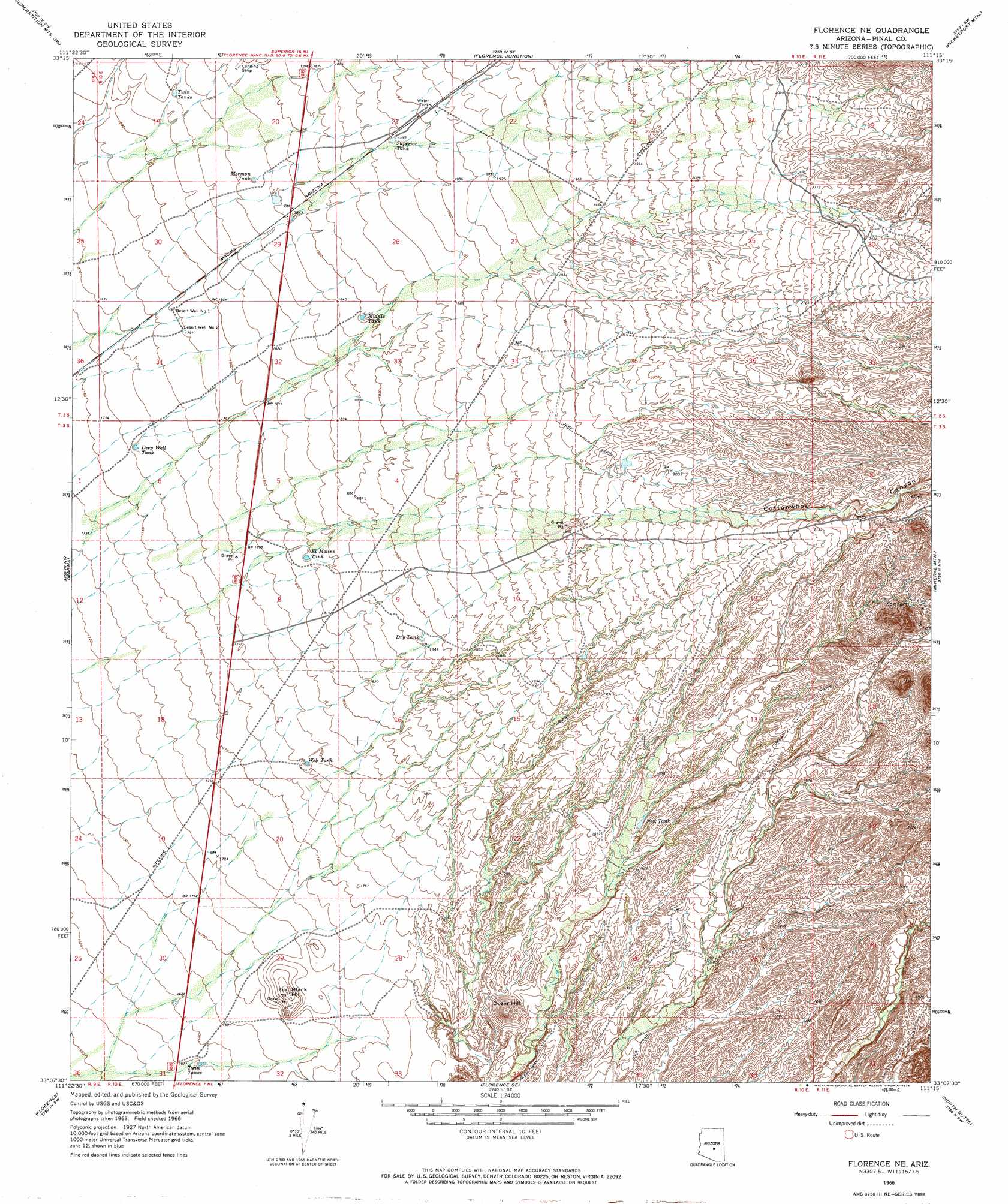
USGS Topo Quad 33111b3 - 1:24,000 scale
| Topo Map Name: | Florence Ne |
| USGS Topo Quad ID: | 33111b3 |
| Print Size: | ca. 21 1/4" wide x 27" high |
| Southeast Coordinates: | 33.125° N latitude / 111.25° W longitude |
| Map Center Coordinates: | 33.1875° N latitude / 111.3125° W longitude |
| U.S. State: | AZ |
| Filename: | o33111b3.jpg |
| Download Map JPG Image: | Florence Ne topo map 1:24,000 scale |
| Map Type: | Topographic |
| Topo Series: | 7.5´ |
| Map Scale: | 1:24,000 |
| Source of Map Images: | United States Geological Survey (USGS) |
| Alternate Map Versions: |
Florence NE AZ 1966, updated 1969 Download PDF Buy paper map Florence NE AZ 1966, updated 1974 Download PDF Buy paper map Florence NE AZ 1966, updated 1974 Download PDF Buy paper map Florence NE AZ 2011 Download PDF Buy paper map Florence NE AZ 2014 Download PDF Buy paper map |
1:24,000 Topo Quads surrounding Florence Ne
Apache Junction |
Goldfield |
Weavers Needle |
Iron Mountain |
Haunted Canyon |
Desert Well |
Superstition Mountains Sw |
Florence Junction |
Picketpost Mountain |
Superior |
Sacaton Ne |
Magma |
Florence Ne |
Mineral Mountain |
Teapot Mountain |
Blackwater |
Florence |
Florence Se |
North Butte |
Grayback |
Coolidge |
Valley Farms |
Cactus Forest |
Ninetysix Hills Nw |
Ninetysix Hills Ne |
> Back to 33111a1 at 1:100,000 scale
> Back to 33110a1 at 1:250,000 scale
> Back to U.S. Topo Maps home
Florence Ne topo map: Gazetteer
Florence Ne: Reservoirs
Deep Well Tank elevation 537m 1761′Dry Tank elevation 562m 1843′
El Molino Tank elevation 550m 1804′
Middle Tank elevation 564m 1850′
Mormon Tank elevation 559m 1833′
New Tank elevation 564m 1850′
Superior Tank elevation 577m 1893′
Twin Tanks elevation 555m 1820′
Web Tank elevation 540m 1771′
Florence Ne: Summits
Black Hill elevation 543m 1781′Dozer Hill elevation 568m 1863′
Florence Ne: Valleys
Cottonwood Canyon elevation 601m 1971′Florence Ne: Wells
Desert Well Number One elevation 546m 1791′Desert Well Number Two elevation 546m 1791′
Florence Ne digital topo map on disk
Buy this Florence Ne topo map showing relief, roads, GPS coordinates and other geographical features, as a high-resolution digital map file on DVD: