Picketpost Mountain Topo Map Arizona
To zoom in, hover over the map of Picketpost Mountain
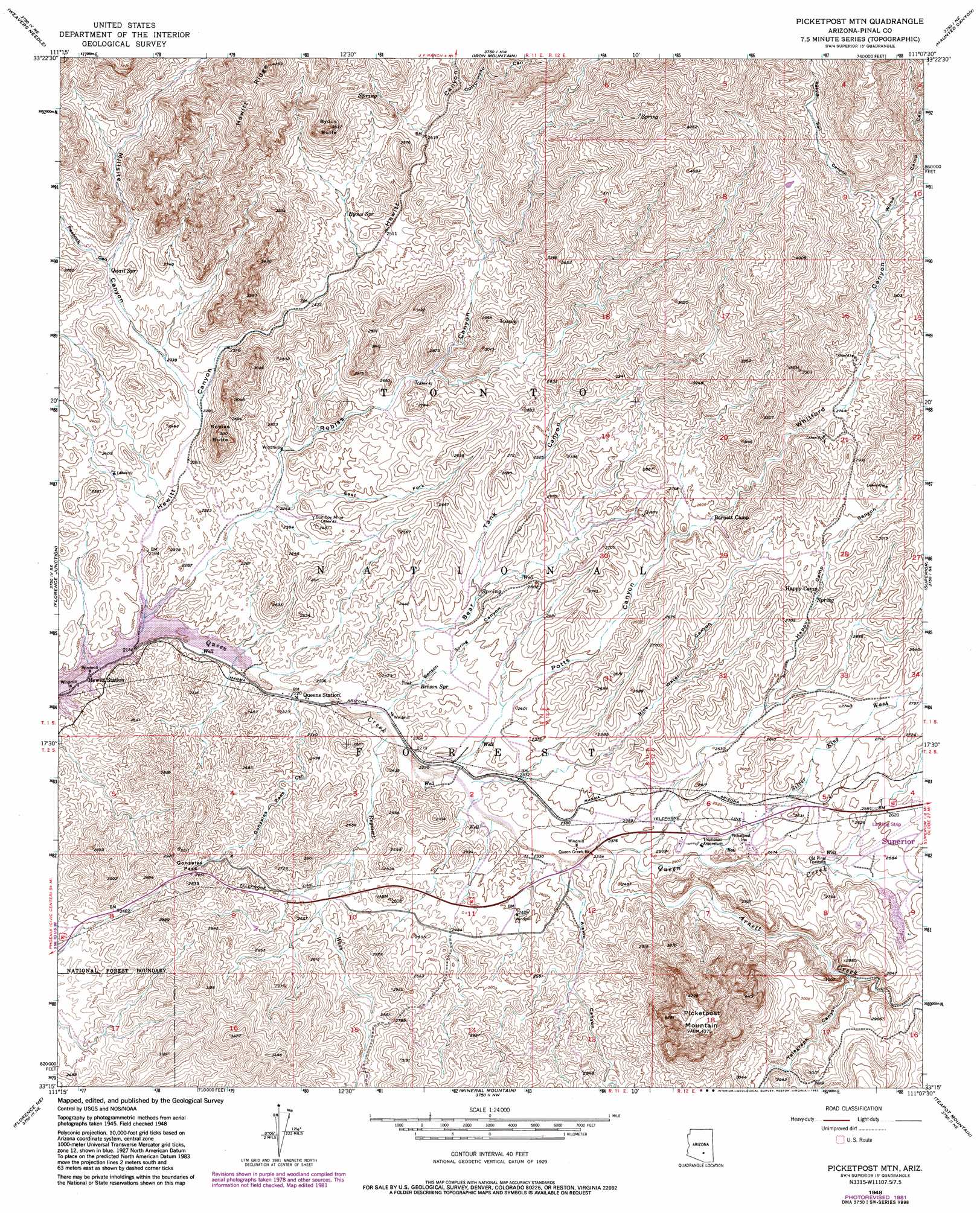
USGS Topo Quad 33111c2 - 1:24,000 scale
| Topo Map Name: | Picketpost Mountain |
| USGS Topo Quad ID: | 33111c2 |
| Print Size: | ca. 21 1/4" wide x 27" high |
| Southeast Coordinates: | 33.25° N latitude / 111.125° W longitude |
| Map Center Coordinates: | 33.3125° N latitude / 111.1875° W longitude |
| U.S. State: | AZ |
| Filename: | o33111c2.jpg |
| Download Map JPG Image: | Picketpost Mountain topo map 1:24,000 scale |
| Map Type: | Topographic |
| Topo Series: | 7.5´ |
| Map Scale: | 1:24,000 |
| Source of Map Images: | United States Geological Survey (USGS) |
| Alternate Map Versions: |
Picketpost Mtn AZ 1948, updated 1961 Download PDF Buy paper map Picketpost Mtn AZ 1948, updated 1970 Download PDF Buy paper map Picketpost Mtn AZ 1948, updated 1982 Download PDF Buy paper map Picketpost Mtn AZ 1948, updated 1982 Download PDF Buy paper map Picketpost Mtn AZ 1949 Download PDF Buy paper map Picketpost Mountain AZ 2004, updated 2007 Download PDF Buy paper map Picketpost Mountain AZ 2011 Download PDF Buy paper map Picketpost Mountain AZ 2014 Download PDF Buy paper map |
| FStopo: | US Forest Service topo Picketpost Mountain is available: Download FStopo PDF Download FStopo TIF |
1:24,000 Topo Quads surrounding Picketpost Mountain
Mormon Flat Dam |
Horse Mesa Dam |
Pinyon Mountain |
Two Bar Mountain |
Salt River Peak |
Goldfield |
Weavers Needle |
Iron Mountain |
Haunted Canyon |
Inspiration |
Superstition Mountains Sw |
Florence Junction |
Picketpost Mountain |
Superior |
Pinal Ranch |
Magma |
Florence Ne |
Mineral Mountain |
Teapot Mountain |
Hot Tamale Peak |
Florence |
Florence Se |
North Butte |
Grayback |
Kearny |
> Back to 33111a1 at 1:100,000 scale
> Back to 33110a1 at 1:250,000 scale
> Back to U.S. Topo Maps home
Picketpost Mountain topo map: Gazetteer
Picketpost Mountain: Airports
Superior Municipal Airport elevation 789m 2588′Picketpost Mountain: Bridges
Queen Creek Bridge elevation 720m 2362′Picketpost Mountain: Gaps
Gonzales Pass elevation 802m 2631′Picketpost Mountain: Mines
Bomboy Mine elevation 718m 2355′Perlite Mine elevation 788m 2585′
Picketpost Mountain: Parks
Picketpost Mountain Research Natural Area elevation 915m 3001′Thompson Arboretum elevation 741m 2431′
Picketpost Mountain: Reservoirs
Arboretum Tank elevation 745m 2444′Dugan Tank elevation 1030m 3379′
Gonzales Tank elevation 799m 2621′
Highway Tank elevation 779m 2555′
Highway Tank elevation 797m 2614′
Javelina Tank elevation 1081m 3546′
Midway Tank elevation 892m 2926′
Rebel Tank elevation 779m 2555′
Picketpost Mountain: Ridges
Hewitt Ridge elevation 1171m 3841′Picketpost Mountain: Springs
Benson Spring elevation 707m 2319′Byous Spring elevation 781m 2562′
Campsite Spring elevation 781m 2562′
Canyon Spring elevation 884m 2900′
Happy Camp Spring elevation 817m 2680′
Lower Railroad Spring elevation 754m 2473′
Millsite Spring elevation 844m 2769′
Negro Head Spring elevation 875m 2870′
Perlite Spring elevation 804m 2637′
Quail Spring elevation 755m 2477′
Rattlesnake Spring elevation 812m 2664′
Thompson Spring elevation 806m 2644′
Picketpost Mountain: Streams
Arnett Creek elevation 720m 2362′Reymert Wash elevation 694m 2276′
Silver King Wash elevation 733m 2404′
Picketpost Mountain: Summits
Byous Butte elevation 1076m 3530′Picketpost Mountain elevation 1336m 4383′
Roblas Butte elevation 928m 3044′
Picketpost Mountain: Valleys
Alamo Canyon elevation 720m 2362′Arnett Canyon elevation 720m 2362′
Bear Tank Canyon elevation 688m 2257′
Benson Spring Canyon elevation 692m 2270′
Cottonwood Canyon elevation 823m 2700′
East Fork Roblas Canyon elevation 695m 2280′
Gonzales Pass Canyon elevation 683m 2240′
Happy Camp Canyon elevation 781m 2562′
Hewitt Canyon elevation 656m 2152′
Millsite Canyon elevation 705m 2312′
Peacock Canyon elevation 756m 2480′
Potts Canyon elevation 707m 2319′
Reavis Trail Canyon elevation 890m 2919′
Rice Water Canyon elevation 720m 2362′
Roblas Canyon elevation 671m 2201′
Telegraph Canyon elevation 780m 2559′
Whitford Canyon elevation 767m 2516′
Wood Camp Canyon elevation 890m 2919′
Picketpost Mountain: Wells
Nobel Well elevation 779m 2555′Preston Well elevation 822m 2696′
Reymert Well elevation 833m 2732′
Roblas Well elevation 706m 2316′
Vallies Well elevation 702m 2303′
Picketpost Mountain digital topo map on disk
Buy this Picketpost Mountain topo map showing relief, roads, GPS coordinates and other geographical features, as a high-resolution digital map file on DVD: