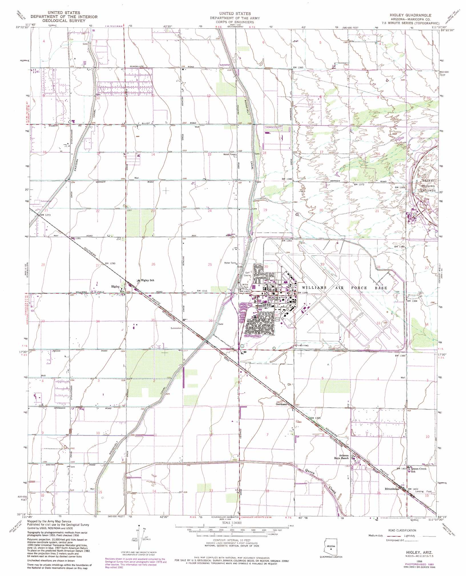
Higley Topo Map Arizona
To zoom in, hover over the map of Higley
USGS Topo Quad 33111c6 - 1:24,000 scale
| Topo Map Name: | Higley |
| USGS Topo Quad ID: | 33111c6 |
| Print Size: | ca. 21 1/4" wide x 27" high |
| Southeast Coordinates: | 33.25° N latitude / 111.625° W longitude |
| Map Center Coordinates: | 33.3125° N latitude / 111.6875° W longitude |
| U.S. State: | AZ |
| Filename: | o33111c6.jpg |
| Download Map JPG Image: | Higley topo map 1:24,000 scale |
| Map Type: | Topographic |
| Topo Series: | 7.5´ |
| Map Scale: | 1:24,000 |
| Source of Map Images: | United States Geological Survey (USGS) |
| Alternate Map Versions: |
Higley AZ 1956, updated 1959 Download PDF Buy paper map Higley AZ 1956, updated 1959 Download PDF Buy paper map Higley AZ 1956, updated 1975 Download PDF Buy paper map Higley AZ 1956, updated 1982 Download PDF Buy paper map Higley AZ 1956, updated 1982 Download PDF Buy paper map Higley AZ 1971, updated 1972 Download PDF Buy paper map Higley AZ 2011 Download PDF Buy paper map Higley AZ 2014 Download PDF Buy paper map |
1:24,000 Topo Quads surrounding Higley
Paradise Valley |
Sawik Mountain |
Granite Reef Dam |
Stewart Mountain |
Mormon Flat Dam |
Tempe |
Mesa |
Buckhorn |
Apache Junction |
Goldfield |
Guadalupe |
Chandler |
Higley |
Desert Well |
Superstition Mountains Sw |
Gila Butte Nw |
Gila Butte |
Chandler Heights |
Sacaton Ne |
Magma |
Sacaton Butte |
Gila Butte Se |
Sacaton |
Blackwater |
Florence |
> Back to 33111a1 at 1:100,000 scale
> Back to 33110a1 at 1:250,000 scale
> Back to U.S. Topo Maps home
Higley topo map: Gazetteer
Higley: Airports
Williams Gateway Airport elevation 415m 1361′Higley: Canals
Queen Creek Canal elevation 415m 1361′Roosevelt Canal elevation 403m 1322′
Higley: Parks
Crossroads Park elevation 390m 1279′Willie Park elevation 406m 1332′
Higley: Populated Places
Germann elevation 415m 1361′Higley elevation 396m 1299′
Higley: Post Offices
Boys Ranch Post Office elevation 422m 1384′Higley Post Office elevation 396m 1299′
Higley: Streams
Queen Creek elevation 415m 1361′Higley digital topo map on disk
Buy this Higley topo map showing relief, roads, GPS coordinates and other geographical features, as a high-resolution digital map file on DVD: