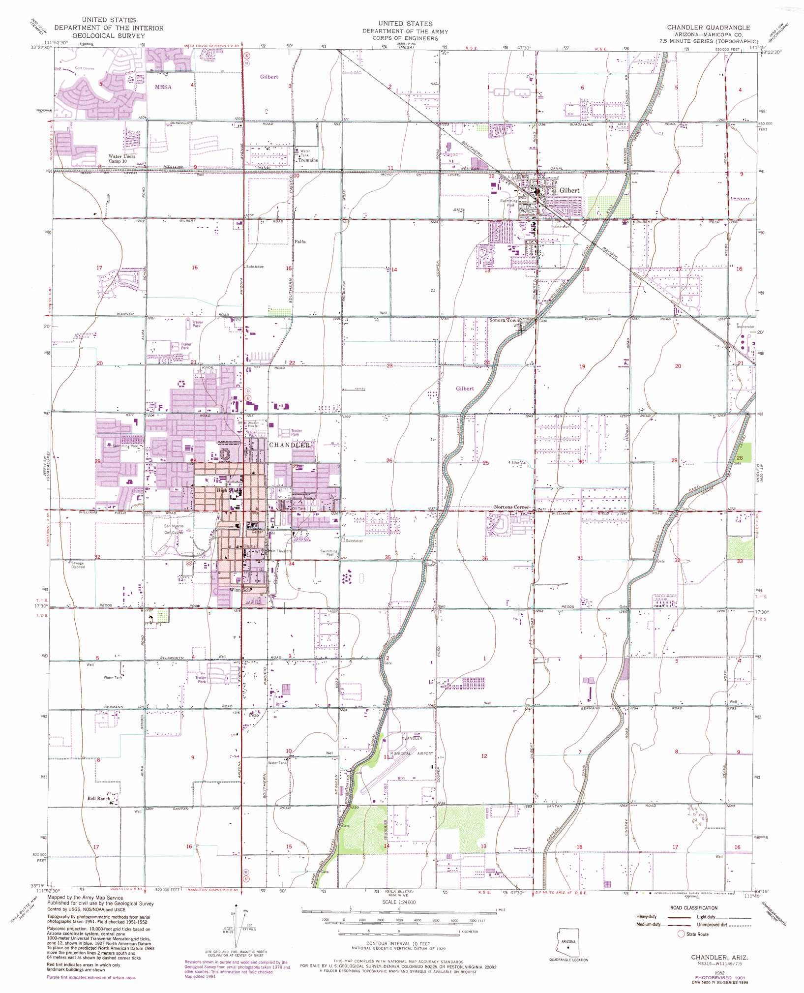
Chandler Topo Map Arizona
To zoom in, hover over the map of Chandler
USGS Topo Quad 33111c7 - 1:24,000 scale
| Topo Map Name: | Chandler |
| USGS Topo Quad ID: | 33111c7 |
| Print Size: | ca. 21 1/4" wide x 27" high |
| Southeast Coordinates: | 33.25° N latitude / 111.75° W longitude |
| Map Center Coordinates: | 33.3125° N latitude / 111.8125° W longitude |
| U.S. State: | AZ |
| Filename: | o33111c7.jpg |
| Download Map JPG Image: | Chandler topo map 1:24,000 scale |
| Map Type: | Topographic |
| Topo Series: | 7.5´ |
| Map Scale: | 1:24,000 |
| Source of Map Images: | United States Geological Survey (USGS) |
| Alternate Map Versions: |
Chandler AZ 1952, updated 1957 Download PDF Buy paper map Chandler AZ 1952, updated 1968 Download PDF Buy paper map Chandler AZ 1952, updated 1975 Download PDF Buy paper map Chandler AZ 1952, updated 1982 Download PDF Buy paper map Chandler AZ 1952, updated 1982 Download PDF Buy paper map Chandler AZ 1971, updated 1972 Download PDF Buy paper map Chandler AZ 2011 Download PDF Buy paper map Chandler AZ 2014 Download PDF Buy paper map |
1:24,000 Topo Quads surrounding Chandler
Sunnyslope |
Paradise Valley |
Sawik Mountain |
Granite Reef Dam |
Stewart Mountain |
Phoenix |
Tempe |
Mesa |
Buckhorn |
Apache Junction |
Lone Butte |
Guadalupe |
Chandler |
Higley |
Desert Well |
Pima Butte |
Gila Butte Nw |
Gila Butte |
Chandler Heights |
Sacaton Ne |
Maricopa |
Sacaton Butte |
Gila Butte Se |
Sacaton |
Blackwater |
> Back to 33111a1 at 1:100,000 scale
> Back to 33110a1 at 1:250,000 scale
> Back to U.S. Topo Maps home
Chandler topo map: Gazetteer
Chandler: Airports
Chandler Municipal Airport elevation 377m 1236′Chandler Regional Hospital Heliport elevation 366m 1200′
Pixley-Richards Gilbert Heliport elevation 369m 1210′
Chandler: Canals
Consolidated Canal East Branch elevation 376m 1233′Eastern Canal elevation 384m 1259′
Chandler: Parks
Apache Park elevation 369m 1210′Armstrong Park elevation 371m 1217′
Arrowhead Meadows Park elevation 367m 1204′
Doctor Chandler Memorial Park elevation 370m 1213′
East Mini Well Park elevation 372m 1220′
Elgin Park elevation 371m 1217′
Folley Park elevation 373m 1223′
Gilbert Rodeo Park elevation 387m 1269′
John Allen Park elevation 376m 1233′
Library Park elevation 376m 1233′
Palo Verde Park elevation 369m 1210′
Palo Verde Park elevation 366m 1200′
Parquasito Verde Park elevation 376m 1233′
West Mine Well Park elevation 370m 1213′
Chandler: Populated Places
A and F Trailer Court elevation 370m 1213′Amberwood elevation 367m 1204′
Amberwood II elevation 369m 1210′
Breckenridge Manor elevation 375m 1230′
Bridgeport elevation 366m 1200′
Brighton Place elevation 367m 1204′
Casa Linda elevation 368m 1207′
Casas del Campo Mobile Home Park elevation 371m 1217′
Cedar Ridge elevation 370m 1213′
Chandler elevation 370m 1213′
Chandler Gardens Mobile Home Park elevation 372m 1220′
Chandler Meadows Mobile Home Park elevation 371m 1217′
Cloverleaf elevation 366m 1200′
Colonial Coronita elevation 380m 1246′
Dobson Ranch elevation 367m 1204′
Elmwood Trailer Park elevation 372m 1220′
Esplanada elevation 368m 1207′
Evergreen Villa Mobile Home Park elevation 369m 1210′
Falfa elevation 371m 1217′
Gilbert elevation 377m 1236′
Green Tree Mobile Home Park elevation 372m 1220′
Hacienda Solano Park elevation 381m 1250′
Kon Tiki Mobile Home Park elevation 369m 1210′
Legante Paseo elevation 367m 1204′
Marlborough Mesa elevation 368m 1207′
Mission Valley elevation 368m 1207′
New Horizons elevation 368m 1207′
Nortons Corner elevation 381m 1250′
Pozo elevation 370m 1213′
Quail Place elevation 365m 1197′
Rancho de Chandler elevation 373m 1223′
San Carlos elevation 368m 1207′
San Tan Mobile Village elevation 381m 1250′
Silvergate II elevation 365m 1197′
Sonora Town elevation 378m 1240′
Stonegate Crossing elevation 371m 1217′
Sun Tech elevation 367m 1204′
Sunridge IV elevation 367m 1204′
Sunshine Valley Mobile Home Park elevation 370m 1213′
The Haciendas elevation 373m 1223′
The West Winds Trailer Court elevation 372m 1220′
Tremaine elevation 369m 1210′
Valley Mobile Homes Estate elevation 370m 1213′
Vista Alegre elevation 369m 1210′
Warner Park elevation 368m 1207′
Wishing Well Trailer Park elevation 373m 1223′
Womack East elevation 368m 1207′
Woodglen elevation 366m 1200′
Chandler: Post Offices
Chandler Post Office elevation 370m 1213′Gilbert Post Office elevation 376m 1233′
Chandler: Reservoirs
Old West Estates Retention Basin elevation 375m 1230′Chandler digital topo map on disk
Buy this Chandler topo map showing relief, roads, GPS coordinates and other geographical features, as a high-resolution digital map file on DVD: