Mesa Topo Map Arizona
To zoom in, hover over the map of Mesa
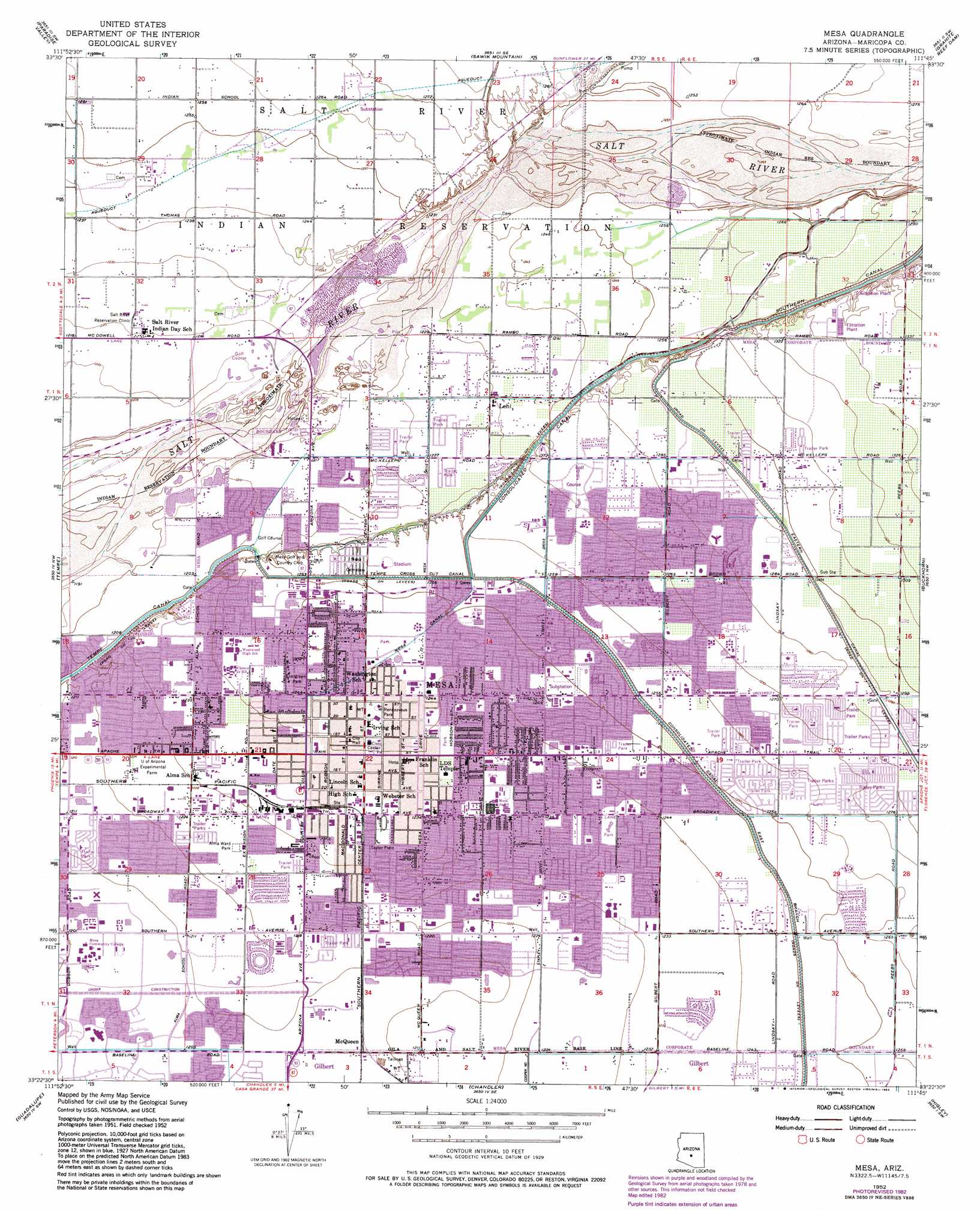
USGS Topo Quad 33111d7 - 1:24,000 scale
| Topo Map Name: | Mesa |
| USGS Topo Quad ID: | 33111d7 |
| Print Size: | ca. 21 1/4" wide x 27" high |
| Southeast Coordinates: | 33.375° N latitude / 111.75° W longitude |
| Map Center Coordinates: | 33.4375° N latitude / 111.8125° W longitude |
| U.S. State: | AZ |
| Filename: | o33111d7.jpg |
| Download Map JPG Image: | Mesa topo map 1:24,000 scale |
| Map Type: | Topographic |
| Topo Series: | 7.5´ |
| Map Scale: | 1:24,000 |
| Source of Map Images: | United States Geological Survey (USGS) |
| Alternate Map Versions: |
Mesa AZ 1952, updated 1957 Download PDF Buy paper map Mesa AZ 1952, updated 1965 Download PDF Buy paper map Mesa AZ 1952, updated 1968 Download PDF Buy paper map Mesa AZ 1952, updated 1983 Download PDF Buy paper map Mesa AZ 1952, updated 1983 Download PDF Buy paper map Mesa AZ 1971, updated 1972 Download PDF Buy paper map Mesa AZ 1971, updated 1987 Download PDF Buy paper map Mesa AZ 1972, updated 1975 Download PDF Buy paper map Mesa AZ 2011 Download PDF Buy paper map Mesa AZ 2014 Download PDF Buy paper map |
1:24,000 Topo Quads surrounding Mesa
Union Hills |
Currys Corner |
Mcdowell Peak |
Fort Mcdowell |
Adams Mesa |
Sunnyslope |
Paradise Valley |
Sawik Mountain |
Granite Reef Dam |
Stewart Mountain |
Phoenix |
Tempe |
Mesa |
Buckhorn |
Apache Junction |
Lone Butte |
Guadalupe |
Chandler |
Higley |
Desert Well |
Pima Butte |
Gila Butte Nw |
Gila Butte |
Chandler Heights |
Sacaton Ne |
> Back to 33111a1 at 1:100,000 scale
> Back to 33110a1 at 1:250,000 scale
> Back to U.S. Topo Maps home
Mesa topo map: Gazetteer
Mesa: Airports
1st Street/Center Parking Garage Heliport elevation 378m 1240′J S J Airport elevation 370m 1213′
JSJ Heliport elevation 370m 1213′
Mesa Hospital Medical Center Heliport elevation 378m 1240′
Mesa Lutheran Hospital Heliport elevation 381m 1250′
Ross Airport elevation 377m 1236′
Mesa: Canals
Acequis Mesa (historical) elevation 378m 1240′Canal Alma (historical) elevation 380m 1246′
Canal Ancho (historical) elevation 378m 1240′
Canal Caliche (historical) elevation 379m 1243′
Canal Camino (historical) elevation 375m 1230′
Canal Camino Lower Branch (historical) elevation 373m 1223′
Canal Casas (historical) elevation 382m 1253′
Canal Crismon (historical) elevation 380m 1246′
Canal Eastern (historical) elevation 378m 1240′
Canal Eight (historical) elevation 366m 1200′
Canal Eleven (historical) elevation 378m 1240′
Canal Lehi South Branch (historical) elevation 364m 1194′
Canal Mesa (historical) elevation 382m 1253′
Canal Minor (historical) elevation 378m 1240′
Canal Thirteen (historical) elevation 371m 1217′
Canal Ultimo (historical) elevation 375m 1230′
Consolidated Canal elevation 378m 1240′
Lewis Canal (historical) elevation 381m 1250′
Mesa Canal elevation 380m 1246′
Tempe Cross Cut Canal elevation 382m 1253′
Mesa: Parks
Alma Ward Park elevation 374m 1227′Brinton Desert Botanical Garden elevation 382m 1253′
Chaparral Park elevation 390m 1279′
Country Manor Subdivision Mini Park elevation 389m 1276′
Country Side Estates Park Site elevation 382m 1253′
Emerald Acres Subdivision Number Two Mini Park elevation 374m 1227′
Escobedo Park elevation 379m 1243′
Evergreen Park elevation 380m 1246′
Fitch Park elevation 380m 1246′
Gilbert Estates Phase Two Mini Park elevation 389m 1276′
Heritage Park elevation 369m 1210′
Ho Ho Kam Park elevation 383m 1256′
Jackrabbit Stadium elevation 378m 1240′
Joseph Reed Park elevation 378m 1240′
Kirk Estates Subdivision Mini Park elevation 384m 1259′
Kleinman Park elevation 373m 1223′
McAfee Place Unit Two Mini Park elevation 377m 1236′
Mesa Meadows Subdivision Mini Park elevation 372m 1220′
Mesa Tierra Number Three Subdivision Mini Park elevation 376m 1233′
Mesa Villas Number Two Mini Park elevation 384m 1259′
Oakwood Estates Subdivision Mini Park elevation 385m 1263′
Old West Valley Subdivision Mini Park elevation 372m 1220′
Park of the Canals elevation 383m 1256′
Pioneer Park elevation 378m 1240′
Pleasant Shadows Subdivision Mini Park elevation 373m 1223′
Porter Park elevation 381m 1250′
Powell Estates Subdivision Mini Park elevation 372m 1220′
Reed Park elevation 378m 1240′
Rendezvous Park elevation 379m 1243′
Rotary Park elevation 374m 1227′
Sherwood Park elevation 369m 1210′
Stapley Park elevation 378m 1240′
Stewart Park elevation 376m 1233′
Sunset Mesa Subdivision Mini Park elevation 369m 1210′
Taylor Field elevation 377m 1236′
Val Vista Village Trailer Park Mini Park elevation 392m 1286′
Mesa: Populated Places
Alma Gardens elevation 373m 1223′Alma Meadows Mobile Home Park elevation 373m 1223′
Ambassador Downs Mobile Home Park elevation 380m 1246′
Apache West Mobile Village elevation 376m 1233′
Beverly Trailer Park elevation 374m 1227′
Bonds Trailer Park elevation 378m 1240′
Brentwood Mobile Manor elevation 393m 1289′
Brentwood West elevation 387m 1269′
Castillo Nuevo Mobile Home Park elevation 387m 1269′
Citrus Grove Trailer Court elevation 376m 1233′
Coronado Mobile Home Park elevation 384m 1259′
Country Club Village Mobile Home Park elevation 372m 1220′
Country Cousins Mobile Mecca elevation 371m 1217′
Cypress Estates elevation 391m 1282′
Deserama Mobile Ranch elevation 384m 1259′
Eastway Mobile Home Park elevation 373m 1223′
El Mar Trailer Court elevation 388m 1272′
El Mirage elevation 391m 1282′
Fuller Ranch elevation 378m 1240′
Golden West Estates elevation 391m 1282′
Hawaiian Village Mobile Home Park elevation 369m 1210′
Hohokam Village elevation 382m 1253′
Holiday Village Mobile Home Park elevation 373m 1223′
Homestead elevation 400m 1312′
Imperial Mobile Home Park elevation 383m 1256′
Karmella Mobile Home Park elevation 374m 1227′
Kay-Bee Mobile Villa elevation 372m 1220′
Keats Crossing elevation 368m 1207′
Kingsgate elevation 375m 1230′
Knoell Mesa elevation 377m 1236′
La Casita Mobile Park elevation 373m 1223′
Lazona Trailer Court elevation 378m 1240′
Lehi elevation 375m 1230′
Los Maderas elevation 392m 1286′
McQueen elevation 369m 1210′
Meadowvale elevation 391m 1282′
Mesa elevation 378m 1240′
Mesa Gardens Mobile Home Park elevation 376m 1233′
Mesa Grande Trailer Ranch elevation 399m 1309′
Mesa Patios elevation 381m 1250′
Mesa Travelodge Mobile Home Park elevation 372m 1220′
MonDak Mobile Home Park elevation 394m 1292′
Palm Gardens Mobile Home Manor elevation 384m 1259′
Paradise Palms Trailer Resorts elevation 380m 1246′
Parkview Mesa elevation 369m 1210′
Rancho de Arboleda elevation 395m 1295′
Sagewood elevation 370m 1213′
Salt River elevation 372m 1220′
Southern Palms Trailer Park elevation 371m 1217′
Summer Place Trails elevation 377m 1236′
Summer Place Village elevation 378m 1240′
Summerplace Green elevation 379m 1243′
Suncrest Villas Mesa elevation 377m 1236′
Sundial Mobile Park elevation 372m 1220′
Sunrise Vista Mobile Home Park elevation 389m 1276′
Suntrails elevation 384m 1259′
Suntree elevation 381m 1250′
Sunview elevation 375m 1230′
Trail Riders Holiday Park elevation 384m 1259′
West Mesa Trailer Court elevation 377m 1236′
Windsor Mobile Home Park elevation 382m 1253′
Wintercone Park elevation 373m 1223′
Woodbridge Crossing elevation 375m 1230′
Woodcreek elevation 368m 1207′
Woodland Heights elevation 383m 1256′
Woodridge Lakes elevation 384m 1259′
Woodside elevation 381m 1250′
Mesa: Post Offices
Mesa Post Office elevation 380m 1246′Pioneer Carrier Annex Post Office elevation 378m 1240′
Salt River Post Office elevation 372m 1220′
Sherwood Post Office elevation 378m 1240′
Mesa: Reservoirs
Country Manor Subdivision Water Retention Basin elevation 389m 1276′Emerald Acres Number Two Subdivision Water Retention Basin elevation 374m 1227′
Gilbert Estates Phase Two Water Retention Basin elevation 389m 1276′
Kirk Estates Subdivision Water Retention Basin elevation 384m 1259′
McAfee Place Unit Two Water Retention Basin elevation 377m 1236′
Mesa Meadows Subdivision Water Retention Basin elevation 372m 1220′
Mesa Tierra Number Three Subdivision Water Retention Basin elevation 376m 1233′
Mesa Villas Number Two Water Retention Basin elevation 384m 1259′
Oakwood Estates Subdivision Water Retention Basin elevation 385m 1263′
Old West Valley Subdivision Water Retention Basin elevation 372m 1220′
Pleasant Shadows Subdivision Water Retention Basin elevation 373m 1223′
Powell Estates Subdivision Water Retention Basin elevation 372m 1220′
Sunset Mesa Subdivision Retention Basin elevation 369m 1210′
Val Vista Village Trailer Park Water Retention Basin elevation 392m 1286′
Mesa digital topo map on disk
Buy this Mesa topo map showing relief, roads, GPS coordinates and other geographical features, as a high-resolution digital map file on DVD: