Mormon Flat Dam Topo Map Arizona
To zoom in, hover over the map of Mormon Flat Dam
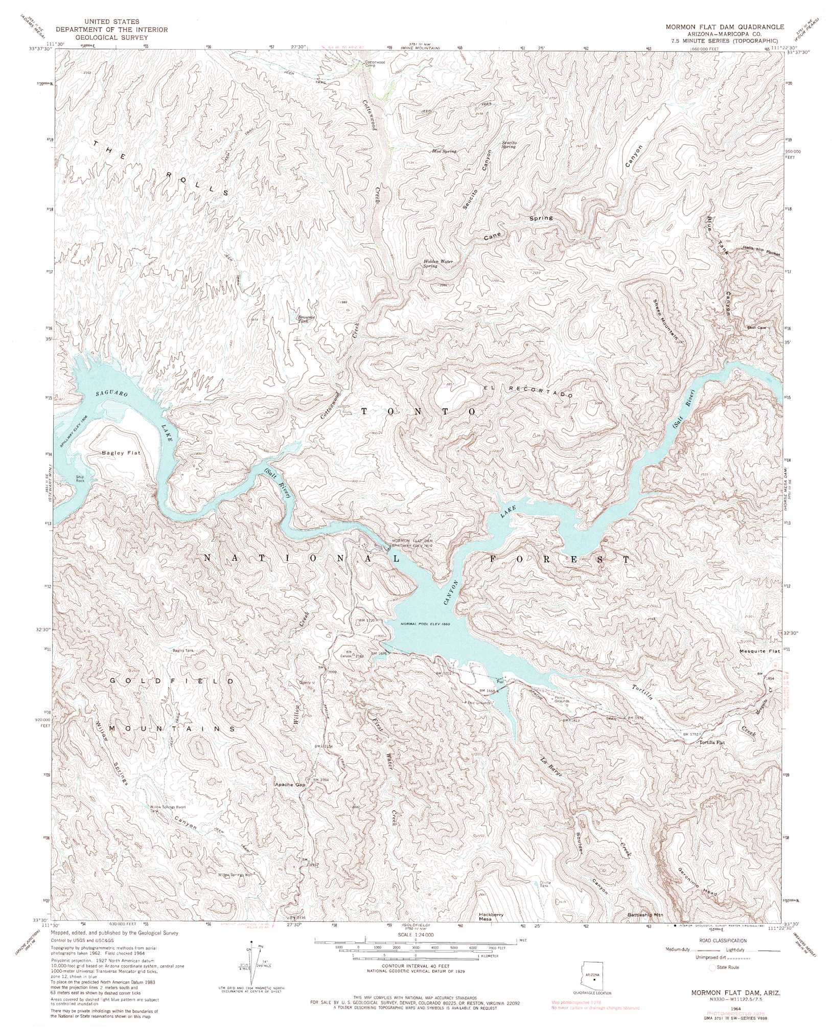
USGS Topo Quad 33111e4 - 1:24,000 scale
| Topo Map Name: | Mormon Flat Dam |
| USGS Topo Quad ID: | 33111e4 |
| Print Size: | ca. 21 1/4" wide x 27" high |
| Southeast Coordinates: | 33.5° N latitude / 111.375° W longitude |
| Map Center Coordinates: | 33.5625° N latitude / 111.4375° W longitude |
| U.S. State: | AZ |
| Filename: | o33111e4.jpg |
| Download Map JPG Image: | Mormon Flat Dam topo map 1:24,000 scale |
| Map Type: | Topographic |
| Topo Series: | 7.5´ |
| Map Scale: | 1:24,000 |
| Source of Map Images: | United States Geological Survey (USGS) |
| Alternate Map Versions: |
Mormon Flat Dam AZ 1964, updated 1965 Download PDF Buy paper map Mormon Flat Dam AZ 1964, updated 1970 Download PDF Buy paper map Mormon Flat Dam AZ 1964, updated 1981 Download PDF Buy paper map Mormon Flat Dam AZ 1964, updated 1981 Download PDF Buy paper map Mormon Flat Dam AZ 2004, updated 2007 Download PDF Buy paper map Mormon Flat Dam AZ 2011 Download PDF Buy paper map Mormon Flat Dam AZ 2014 Download PDF Buy paper map |
| FStopo: | US Forest Service topo Mormon Flat Dam is available: Download FStopo PDF Download FStopo TIF |
1:24,000 Topo Quads surrounding Mormon Flat Dam
Bartlett Dam |
Maverick Mountain |
Boulder Mountain |
Tonto Basin |
Greenback Creek |
Fort Mcdowell |
Adams Mesa |
Mine Mountain |
Four Peaks |
Theodore Roosevelt Dam |
Granite Reef Dam |
Stewart Mountain |
Mormon Flat Dam |
Horse Mesa Dam |
Pinyon Mountain |
Buckhorn |
Apache Junction |
Goldfield |
Weavers Needle |
Iron Mountain |
Higley |
Desert Well |
Superstition Mountains Sw |
Florence Junction |
Picketpost Mountain |
> Back to 33111e1 at 1:100,000 scale
> Back to 33110a1 at 1:250,000 scale
> Back to U.S. Topo Maps home
Mormon Flat Dam topo map: Gazetteer
Mormon Flat Dam: Airports
Mormon Flat Dam Heliport elevation 503m 1650′Mormon Flat Dam: Cliffs
Ittindi Rock elevation 552m 1811′Satchin Cliff elevation 540m 1771′
Mormon Flat Dam: Dams
Mormon Flat Dam elevation 549m 1801′Mormon Flat Dam: Flats
Bagley Flat elevation 529m 1735′Mesquite Flat elevation 581m 1906′
Mormon Flat (historical) elevation 506m 1660′
Mormon Flat Dam: Forests
Mesa Ranger District elevation 766m 2513′Mormon Flat Dam: Gaps
Apache Gap elevation 693m 2273′Mormon Flat Dam: Islands
Ship Rock elevation 460m 1509′Mormon Flat Dam: Parks
Acacia Recreation Site elevation 509m 1669′Boulder Recreation Site elevation 508m 1666′
Laguna Recreation Site One Hundred Fifty elevation 521m 1709′
Palo Verde Recreation Site 147 elevation 513m 1683′
Tortilla Recreation Site elevation 560m 1837′
Mormon Flat Dam: Populated Places
Tortilla Flat elevation 536m 1758′Mormon Flat Dam: Reservoirs
Bagley Tank elevation 632m 2073′Brownie Tank elevation 549m 1801′
Canyon Lake elevation 506m 1660′
Cholla Tank elevation 680m 2230′
Willow Springs Basin Tank elevation 574m 1883′
Mormon Flat Dam: Springs
Blue Spring elevation 608m 1994′Hidden Water Spring elevation 578m 1896′
Secucito Spring elevation 707m 2319′
Willow Spring elevation 607m 1991′
Mormon Flat Dam: Streams
Cottonwood Creek elevation 461m 1512′First Water Creek elevation 519m 1702′
La Barge Creek elevation 509m 1669′
Mesquite Creek elevation 549m 1801′
Tortilla Creek elevation 520m 1706′
Willow Creek elevation 465m 1525′
Mormon Flat Dam: Summits
El Recortado elevation 729m 2391′Geronimo Head elevation 1050m 3444′
Sheep Mountain elevation 1075m 3526′
Whirpool Rock elevation 621m 2037′
Mormon Flat Dam: Valleys
Black Canyon (historical) elevation 559m 1833′Blue Tank Canyon elevation 559m 1833′
Boulder Canyon elevation 525m 1722′
Cane Spring Canyon elevation 522m 1712′
Hells Hip Pocket elevation 643m 2109′
La Barge Canyon elevation 507m 1663′
La Barge Canyon elevation 733m 2404′
Peters Canyon elevation 575m 1886′
Seucito Canyon elevation 595m 1952′
Mormon Flat Dam: Wells
Willow Springs Well elevation 611m 2004′Mormon Flat Dam digital topo map on disk
Buy this Mormon Flat Dam topo map showing relief, roads, GPS coordinates and other geographical features, as a high-resolution digital map file on DVD: