Stewart Mountain Topo Map Arizona
To zoom in, hover over the map of Stewart Mountain
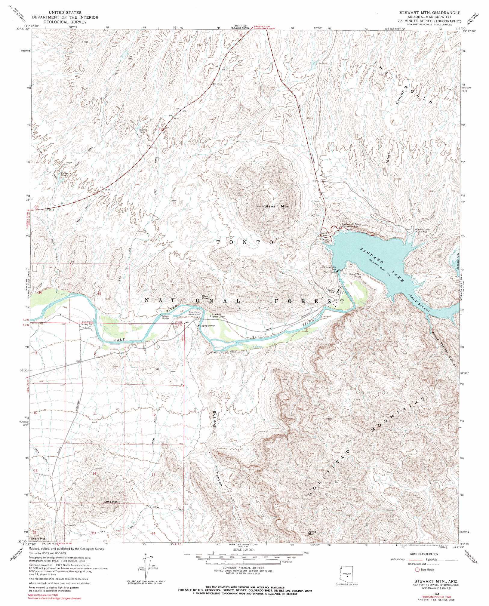
USGS Topo Quad 33111e5 - 1:24,000 scale
| Topo Map Name: | Stewart Mountain |
| USGS Topo Quad ID: | 33111e5 |
| Print Size: | ca. 21 1/4" wide x 27" high |
| Southeast Coordinates: | 33.5° N latitude / 111.5° W longitude |
| Map Center Coordinates: | 33.5625° N latitude / 111.5625° W longitude |
| U.S. State: | AZ |
| Filename: | o33111e5.jpg |
| Download Map JPG Image: | Stewart Mountain topo map 1:24,000 scale |
| Map Type: | Topographic |
| Topo Series: | 7.5´ |
| Map Scale: | 1:24,000 |
| Source of Map Images: | United States Geological Survey (USGS) |
| Alternate Map Versions: |
Stewart Mtn. AZ 1964, updated 1965 Download PDF Buy paper map Stewart Mtn. AZ 1964, updated 1970 Download PDF Buy paper map Stewart Mtn. AZ 1964, updated 1990 Download PDF Buy paper map Stewart Mtn. AZ 1964, updated 1990 Download PDF Buy paper map Stewart Mtn. AZ 1971, updated 1972 Download PDF Buy paper map Stewart Mountain AZ 2004, updated 2007 Download PDF Buy paper map Stewart Mountain AZ 2011 Download PDF Buy paper map Stewart Mountain AZ 2014 Download PDF Buy paper map |
| FStopo: | US Forest Service topo Stewart Mountain is available: Download FStopo PDF Download FStopo TIF |
1:24,000 Topo Quads surrounding Stewart Mountain
Wildcat Hill |
Bartlett Dam |
Maverick Mountain |
Boulder Mountain |
Tonto Basin |
Mcdowell Peak |
Fort Mcdowell |
Adams Mesa |
Mine Mountain |
Four Peaks |
Sawik Mountain |
Granite Reef Dam |
Stewart Mountain |
Mormon Flat Dam |
Horse Mesa Dam |
Mesa |
Buckhorn |
Apache Junction |
Goldfield |
Weavers Needle |
Chandler |
Higley |
Desert Well |
Superstition Mountains Sw |
Florence Junction |
> Back to 33111e1 at 1:100,000 scale
> Back to 33110a1 at 1:250,000 scale
> Back to U.S. Topo Maps home
Stewart Mountain topo map: Gazetteer
Stewart Mountain: Airports
Stewart Mountain Dam Heliport elevation 426m 1397′Stewart Mountain: Bridges
Sheep Bridge elevation 418m 1371′Stewart Mountain: Cliffs
Blue Point elevation 615m 2017′Stewart Mountain: Dams
Stewart Mountain Dam elevation 459m 1505′Stewart Mountain: Parks
Blue Point Picnic Area elevation 420m 1377′Butcher Jones Recreation Site elevation 469m 1538′
Saguaro del Norte Recreation Site elevation 466m 1528′
Stewart Mountain: Reservoirs
Beeline Tank elevation 542m 1778′Flower Tank elevation 476m 1561′
Lost Tank elevation 584m 1916′
Saguaro Lake elevation 460m 1509′
Stewart Mountain: Summits
Dome Mountain elevation 1009m 3310′Goldfield Mountains elevation 840m 2755′
Lone Mountain elevation 835m 2739′
One Mountain elevation 812m 2664′
Stewart Mountain elevation 887m 2910′
Stewart Mountain: Valleys
Bulldog Canyon elevation 420m 1377′Jones Canyon elevation 472m 1548′
Willow Springs Canyon elevation 481m 1578′
Stewart Mountain digital topo map on disk
Buy this Stewart Mountain topo map showing relief, roads, GPS coordinates and other geographical features, as a high-resolution digital map file on DVD: