Adams Mesa Topo Map Arizona
To zoom in, hover over the map of Adams Mesa
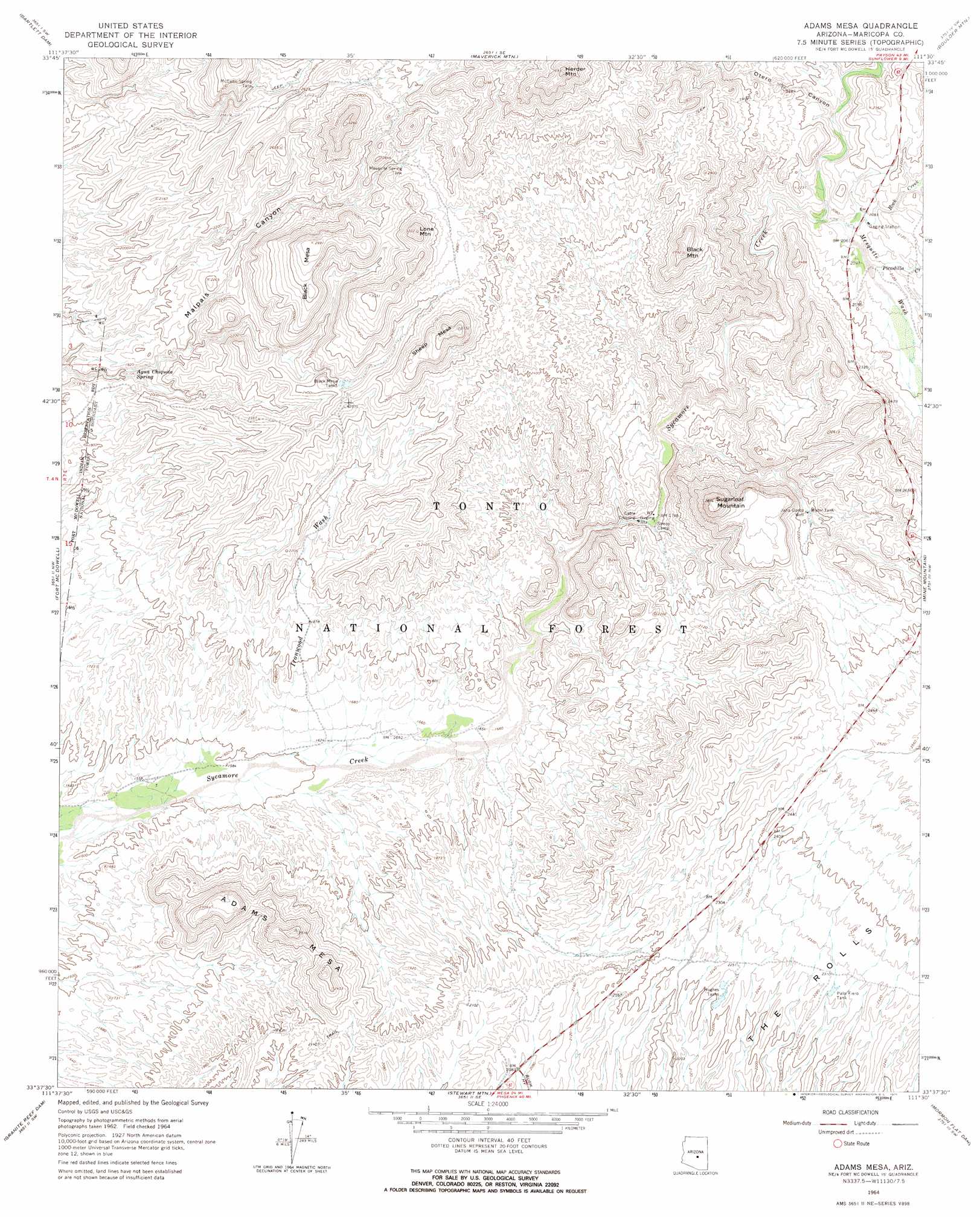
USGS Topo Quad 33111f5 - 1:24,000 scale
| Topo Map Name: | Adams Mesa |
| USGS Topo Quad ID: | 33111f5 |
| Print Size: | ca. 21 1/4" wide x 27" high |
| Southeast Coordinates: | 33.625° N latitude / 111.5° W longitude |
| Map Center Coordinates: | 33.6875° N latitude / 111.5625° W longitude |
| U.S. State: | AZ |
| Filename: | o33111f5.jpg |
| Download Map JPG Image: | Adams Mesa topo map 1:24,000 scale |
| Map Type: | Topographic |
| Topo Series: | 7.5´ |
| Map Scale: | 1:24,000 |
| Source of Map Images: | United States Geological Survey (USGS) |
| Alternate Map Versions: |
Adams Mesa AZ 1964, updated 1965 Download PDF Buy paper map Adams Mesa AZ 1964, updated 1971 Download PDF Buy paper map Adams Mesa AZ 1971, updated 1972 Download PDF Buy paper map Adams Mesa AZ 2004, updated 2007 Download PDF Buy paper map Adams Mesa AZ 2011 Download PDF Buy paper map Adams Mesa AZ 2014 Download PDF Buy paper map |
| FStopo: | US Forest Service topo Adams Mesa is available: Download FStopo PDF Download FStopo TIF |
1:24,000 Topo Quads surrounding Adams Mesa
Humboldt Mountain |
Horseshoe Dam |
Lion Mountain |
Reno Pass |
Kayler Butte |
Wildcat Hill |
Bartlett Dam |
Maverick Mountain |
Boulder Mountain |
Tonto Basin |
Mcdowell Peak |
Fort Mcdowell |
Adams Mesa |
Mine Mountain |
Four Peaks |
Sawik Mountain |
Granite Reef Dam |
Stewart Mountain |
Mormon Flat Dam |
Horse Mesa Dam |
Mesa |
Buckhorn |
Apache Junction |
Goldfield |
Weavers Needle |
> Back to 33111e1 at 1:100,000 scale
> Back to 33110a1 at 1:250,000 scale
> Back to U.S. Topo Maps home
Adams Mesa topo map: Gazetteer
Adams Mesa: Airports
Sycamore Creek Airport elevation 474m 1555′Adams Mesa: Reservoirs
Black Mesa Tanks elevation 735m 2411′Hughes Tank elevation 676m 2217′
McCann Spring Tank elevation 742m 2434′
Mesquite Spring Tank elevation 805m 2641′
Palo Fiero Tank elevation 695m 2280′
Adams Mesa: Springs
Agua Chiquita Spring elevation 572m 1876′Mesquite Spring elevation 768m 2519′
Adams Mesa: Streams
Ironwood Wash elevation 488m 1601′Mesquite Wash elevation 621m 2037′
Picadilla Creek elevation 634m 2080′
Rock Creek elevation 627m 2057′
Adams Mesa: Summits
Adams Mesa elevation 747m 2450′Black Mesa elevation 913m 2995′
Black Mountain elevation 899m 2949′
Herder Mountain elevation 1122m 3681′
Lone Mountain elevation 962m 3156′
Sheep Mesa elevation 953m 3126′
Sugarloaf Mountain elevation 879m 2883′
Adams Mesa: Valleys
Otero Canyon elevation 635m 2083′Adams Mesa: Wells
Jana Gordo Well elevation 658m 2158′Rio Verde Well elevation 507m 1663′
Romo Well elevation 477m 1564′
Adams Mesa digital topo map on disk
Buy this Adams Mesa topo map showing relief, roads, GPS coordinates and other geographical features, as a high-resolution digital map file on DVD: