Currys Corner Topo Map Arizona
To zoom in, hover over the map of Currys Corner
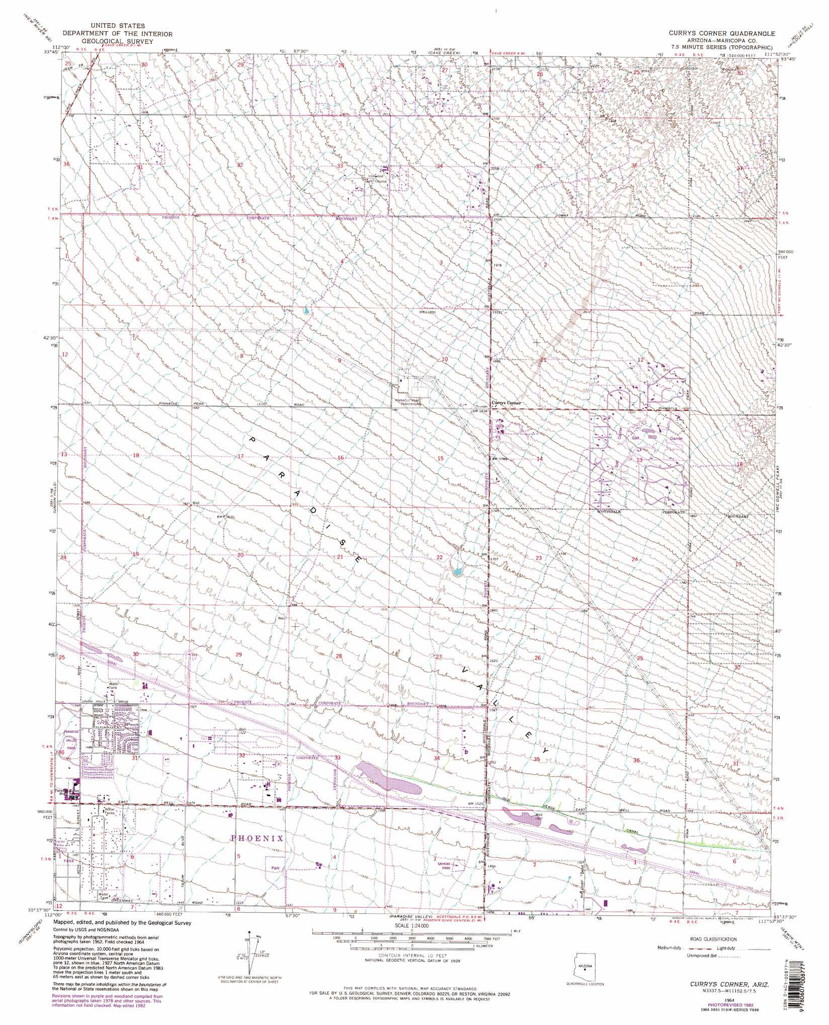
USGS Topo Quad 33111f8 - 1:24,000 scale
| Topo Map Name: | Currys Corner |
| USGS Topo Quad ID: | 33111f8 |
| Print Size: | ca. 21 1/4" wide x 27" high |
| Southeast Coordinates: | 33.625° N latitude / 111.875° W longitude |
| Map Center Coordinates: | 33.6875° N latitude / 111.9375° W longitude |
| U.S. State: | AZ |
| Filename: | o33111f8.jpg |
| Download Map JPG Image: | Currys Corner topo map 1:24,000 scale |
| Map Type: | Topographic |
| Topo Series: | 7.5´ |
| Map Scale: | 1:24,000 |
| Source of Map Images: | United States Geological Survey (USGS) |
| Alternate Map Versions: |
Currys Corner AZ 1964, updated 1965 Download PDF Buy paper map Currys Corner AZ 1964, updated 1971 Download PDF Buy paper map Currys Corner AZ 1964, updated 1975 Download PDF Buy paper map Currys Corner AZ 1964, updated 1983 Download PDF Buy paper map Currys Corner AZ 1964, updated 1983 Download PDF Buy paper map Currys Corner AZ 1971, updated 1972 Download PDF Buy paper map Currys Corner AZ 2011 Download PDF Buy paper map Currys Corner AZ 2014 Download PDF Buy paper map |
1:24,000 Topo Quads surrounding Currys Corner
New River |
Daisy Mountain |
New River Mesa |
Humboldt Mountain |
Horseshoe Dam |
Biscuit Flat |
New River Se |
Cave Creek |
Wildcat Hill |
Bartlett Dam |
Hedgpeth Hills |
Union Hills |
Currys Corner |
Mcdowell Peak |
Fort Mcdowell |
Glendale |
Sunnyslope |
Paradise Valley |
Sawik Mountain |
Granite Reef Dam |
Fowler |
Phoenix |
Tempe |
Mesa |
Buckhorn |
> Back to 33111e1 at 1:100,000 scale
> Back to 33110a1 at 1:250,000 scale
> Back to U.S. Topo Maps home
Currys Corner topo map: Gazetteer
Currys Corner: Airports
Paradise Valley Hospital Emergency Department Heliport elevation 446m 1463′Currys Corner: Canals
Old Verde Canal elevation 467m 1532′Currys Corner: Parks
Sahkoo Park elevation 454m 1489′Scottsdale Horsemens Park elevation 463m 1519′
Currys Corner: Populated Places
Basking Ridge elevation 461m 1512′Country Trace elevation 458m 1502′
Currys Corner elevation 561m 1840′
Desert Highlands elevation 658m 2158′
Desert Ridge elevation 456m 1496′
Greenway Park V elevation 443m 1453′
Happy Valley Ranch elevation 627m 2057′
Heritage North Ranch elevation 461m 1512′
Montclair Terrace elevation 442m 1450′
Oakhurst elevation 459m 1505′
Paradise Valley Miranda elevation 449m 1473′
Pinnacle Paradise elevation 604m 1981′
Pinnacle Peak Country Club Estates elevation 570m 1870′
Pinnacle Peak Estates I elevation 601m 1971′
Pinnacle Peak Estates II elevation 563m 1847′
Pinnacle Peak Estates III elevation 617m 2024′
Pinnacle Peak Shadows elevation 625m 2050′
Pinnacle Peak Village elevation 591m 1938′
Quail Valley elevation 441m 1446′
Rancho Santa Fe elevation 446m 1463′
Sandalwood elevation 440m 1443′
Sunset Ridge I elevation 444m 1456′
Windsong elevation 467m 1532′
Currys Corner digital topo map on disk
Buy this Currys Corner topo map showing relief, roads, GPS coordinates and other geographical features, as a high-resolution digital map file on DVD: