Boulder Mountain Topo Map Arizona
To zoom in, hover over the map of Boulder Mountain
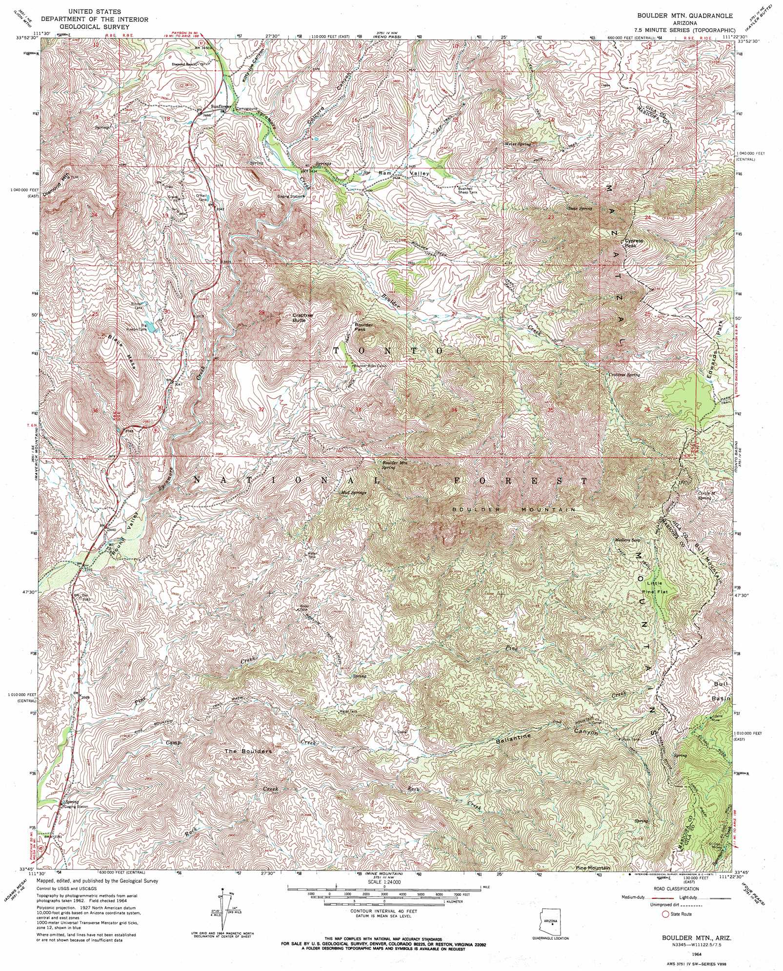
USGS Topo Quad 33111g4 - 1:24,000 scale
| Topo Map Name: | Boulder Mountain |
| USGS Topo Quad ID: | 33111g4 |
| Print Size: | ca. 21 1/4" wide x 27" high |
| Southeast Coordinates: | 33.75° N latitude / 111.375° W longitude |
| Map Center Coordinates: | 33.8125° N latitude / 111.4375° W longitude |
| U.S. State: | AZ |
| Filename: | o33111g4.jpg |
| Download Map JPG Image: | Boulder Mountain topo map 1:24,000 scale |
| Map Type: | Topographic |
| Topo Series: | 7.5´ |
| Map Scale: | 1:24,000 |
| Source of Map Images: | United States Geological Survey (USGS) |
| Alternate Map Versions: |
Boulder Mtn AZ 1964, updated 1965 Download PDF Buy paper map Boulder Mtn AZ 1964, updated 1971 Download PDF Buy paper map Boulder Mtn AZ 1964, updated 1971 Download PDF Buy paper map Boulder Mountain AZ 2004, updated 2007 Download PDF Buy paper map Boulder Mountain AZ 2011 Download PDF Buy paper map Boulder Mountain AZ 2014 Download PDF Buy paper map |
| FStopo: | US Forest Service topo Boulder Mountain is available: Download FStopo PDF Download FStopo TIF |
1:24,000 Topo Quads surrounding Boulder Mountain
Chalk Mountain |
Table Mountain |
Mazatzal Peak |
Gisela |
Sheep Basin Mountain |
Horseshoe Dam |
Lion Mountain |
Reno Pass |
Kayler Butte |
Picture Mountain |
Bartlett Dam |
Maverick Mountain |
Boulder Mountain |
Tonto Basin |
Greenback Creek |
Fort Mcdowell |
Adams Mesa |
Mine Mountain |
Four Peaks |
Theodore Roosevelt Dam |
Granite Reef Dam |
Stewart Mountain |
Mormon Flat Dam |
Horse Mesa Dam |
Pinyon Mountain |
> Back to 33111e1 at 1:100,000 scale
> Back to 33110a1 at 1:250,000 scale
> Back to U.S. Topo Maps home
Boulder Mountain topo map: Gazetteer
Boulder Mountain: Cliffs
Lookout Point elevation 934m 3064′Boulder Mountain: Flats
Little Pine Flat elevation 1669m 5475′Boulder Mountain: Forests
Tonto National Forest elevation 1177m 3861′Boulder Mountain: Gaps
Boulder Pass elevation 1208m 3963′Rincon Pass elevation 1012m 3320′
Boulder Mountain: Mines
El Oso Mine elevation 1758m 5767′Jolene Mine elevation 1513m 4963′
Boulder Mountain: Populated Places
Sunflower elevation 1038m 3405′Boulder Mountain: Reservoirs
Big Rincon Tank elevation 975m 3198′Boulder Tank elevation 1196m 3923′
Bushnell Sheep Tank elevation 1098m 3602′
O'Neil Tank elevation 1072m 3517′
Rincon Tank elevation 992m 3254′
Rock Tank elevation 1549m 5082′
Boulder Mountain: Ridges
Holbrook Ridge (historical) elevation 1847m 6059′Boulder Mountain: Springs
Bear Spring elevation 1570m 5150′Bear Spring elevation 1385m 4543′
Boulder Mountain Spring elevation 1333m 4373′
Camp Creek Spring elevation 671m 2201′
Circle M Spring elevation 1586m 5203′
Crabtree Spring elevation 1290m 4232′
Cypress Spring elevation 1448m 4750′
East Diamond Spring elevation 1140m 3740′
Juniper Spring elevation 1473m 4832′
Medlers Seep elevation 1728m 5669′
Mud Springs elevation 1209m 3966′
O'Neil Spring elevation 1174m 3851′
Steer Spring elevation 1533m 5029′
Sunflower Spring elevation 1009m 3310′
Tunnel Spring elevation 1573m 5160′
Weiss Spring elevation 1195m 3920′
Boulder Mountain: Streams
Boulder Creek elevation 976m 3202′Boulder Mountain: Summits
Black Mesa elevation 1159m 3802′Boulder Mountain elevation 1918m 6292′
Bull Mountain elevation 1795m 5889′
Crabtree Butte elevation 1463m 4799′
Cypress Peak elevation 1805m 5921′
The Boulders elevation 1165m 3822′
Boulder Mountain: Trails
Boulder Creek Trail elevation 1232m 4041′Pine Mountain Trail elevation 1618m 5308′
Pipeline Trail elevation 1125m 3690′
Boulder Mountain: Valleys
Ballantine Canyon elevation 1235m 4051′Colcord Canyon elevation 1026m 3366′
Kitty Joe Canyon elevation 1037m 3402′
Ram Valley elevation 1021m 3349′
Boulder Mountain digital topo map on disk
Buy this Boulder Mountain topo map showing relief, roads, GPS coordinates and other geographical features, as a high-resolution digital map file on DVD: