Cave Creek Topo Map Arizona
To zoom in, hover over the map of Cave Creek
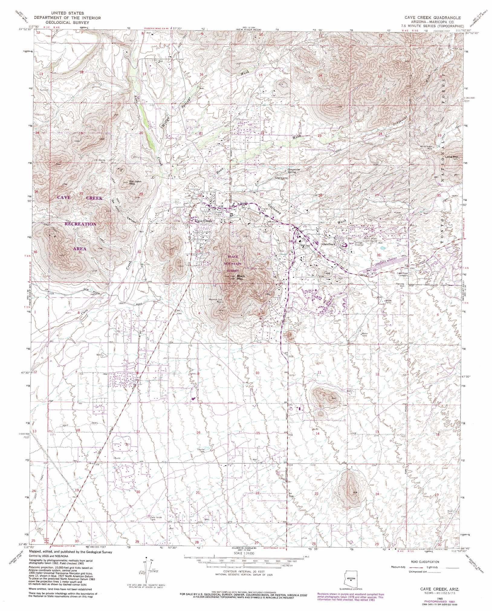
USGS Topo Quad 33111g8 - 1:24,000 scale
| Topo Map Name: | Cave Creek |
| USGS Topo Quad ID: | 33111g8 |
| Print Size: | ca. 21 1/4" wide x 27" high |
| Southeast Coordinates: | 33.75° N latitude / 111.875° W longitude |
| Map Center Coordinates: | 33.8125° N latitude / 111.9375° W longitude |
| U.S. State: | AZ |
| Filename: | o33111g8.jpg |
| Download Map JPG Image: | Cave Creek topo map 1:24,000 scale |
| Map Type: | Topographic |
| Topo Series: | 7.5´ |
| Map Scale: | 1:24,000 |
| Source of Map Images: | United States Geological Survey (USGS) |
| Alternate Map Versions: |
Cave Creek AZ 1965, updated 1967 Download PDF Buy paper map Cave Creek AZ 1965, updated 1973 Download PDF Buy paper map Cave Creek AZ 1965, updated 1983 Download PDF Buy paper map Cave Creek AZ 2004, updated 2007 Download PDF Buy paper map Cave Creek AZ 2011 Download PDF Buy paper map Cave Creek AZ 2014 Download PDF Buy paper map |
| FStopo: | US Forest Service topo Cave Creek is available: Download FStopo PDF Download FStopo TIF |
1:24,000 Topo Quads surrounding Cave Creek
Black Canyon City |
Squaw Creek Mesa |
Cooks Mesa |
Rover Peak |
Chalk Mountain |
New River |
Daisy Mountain |
New River Mesa |
Humboldt Mountain |
Horseshoe Dam |
Biscuit Flat |
New River Se |
Cave Creek |
Wildcat Hill |
Bartlett Dam |
Hedgpeth Hills |
Union Hills |
Currys Corner |
Mcdowell Peak |
Fort Mcdowell |
Glendale |
Sunnyslope |
Paradise Valley |
Sawik Mountain |
Granite Reef Dam |
> Back to 33111e1 at 1:100,000 scale
> Back to 33110a1 at 1:250,000 scale
> Back to U.S. Topo Maps home
Cave Creek topo map: Gazetteer
Cave Creek: Airports
Carefree Airport elevation 769m 2522′Carefree Heliport elevation 720m 2362′
Sky Ranch Carefree Airport elevation 769m 2522′
The Boulders Heliport elevation 714m 2342′
Cave Creek: Mines
Mormon Girl Mine elevation 743m 2437′White Eagle Mine elevation 829m 2719′
Cave Creek: Parks
Black Mountain Summit Park elevation 968m 3175′Carefree Sun Dial elevation 720m 2362′
Cave Creek Recreation Area elevation 748m 2454′
Cave Creek: Populated Places
Carefree elevation 726m 2381′Carefree Foothills elevation 652m 2139′
Cave Creek elevation 648m 2125′
Desert Wind elevation 600m 1968′
Dixileta Verde elevation 671m 2201′
Dove Valley Ranch elevation 594m 1948′
Lone Mountain Ranch elevation 621m 2037′
Sincuidados elevation 701m 2299′
Trovia elevation 588m 1929′
Cave Creek: Post Offices
Carefree Post Office elevation 719m 2358′Cave Creek Post Office elevation 654m 2145′
Cave Creek: Reservoirs
Charlie Tank elevation 638m 2093′Palo Verde Tank elevation 598m 1961′
Rock Tank elevation 744m 2440′
Cave Creek: Springs
Grapevine Spring elevation 704m 2309′Cave Creek: Streams
Galloway Wash elevation 642m 2106′Grapevine Wash elevation 751m 2463′
Rowe Wash elevation 620m 2034′
Willow Springs Wash elevation 621m 2037′
Cave Creek: Summits
Black Mountain elevation 1030m 3379′Go John Mountain elevation 776m 2545′
Lone Mountain elevation 1022m 3353′
Cave Creek: Valleys
Go John Canyon elevation 608m 1994′Cave Creek: Wells
Jim Adams Well elevation 683m 2240′Parrette Well elevation 778m 2552′
Cave Creek digital topo map on disk
Buy this Cave Creek topo map showing relief, roads, GPS coordinates and other geographical features, as a high-resolution digital map file on DVD: