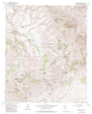
Humboldt Mountain Topo Map Arizona
To zoom in, hover over the map of Humboldt Mountain
USGS Topo Quad 33111h7 - 1:24,000 scale
| Topo Map Name: | Humboldt Mountain |
| USGS Topo Quad ID: | 33111h7 |
| Print Size: | ca. 21 1/4" wide x 27" high |
| Southeast Coordinates: | 33.875° N latitude / 111.75° W longitude |
| Map Center Coordinates: | 33.9375° N latitude / 111.8125° W longitude |
| U.S. State: | AZ |
| Filename: | o33111h7.jpg |
| Download Map JPG Image: | Humboldt Mountain topo map 1:24,000 scale |
| Map Type: | Topographic |
| Topo Series: | 7.5´ |
| Map Scale: | 1:24,000 |
| Source of Map Images: | United States Geological Survey (USGS) |
| Alternate Map Versions: |
Humboldt Mtn. AZ 1964, updated 1965 Download PDF Buy paper map Humboldt Mtn. AZ 1964, updated 1972 Download PDF Buy paper map Humboldt Mtn. AZ 1964, updated 1984 Download PDF Buy paper map Humboldt Mtn. AZ 1964, updated 1984 Download PDF Buy paper map Humboldt Mountain AZ 2004, updated 2006 Download PDF Buy paper map Humboldt Mountain AZ 2011 Download PDF Buy paper map Humboldt Mountain AZ 2014 Download PDF Buy paper map |
| FStopo: | US Forest Service topo Humboldt Mountain is available: Download FStopo PDF Download FStopo TIF |
1:24,000 Topo Quads surrounding Humboldt Mountain
> Back to 33111e1 at 1:100,000 scale
> Back to 33110a1 at 1:250,000 scale
> Back to U.S. Topo Maps home
Humboldt Mountain topo map: Gazetteer
Humboldt Mountain: Basins
Buck Basin elevation 1026m 3366′Humboldt Mountain: Flats
Deer Flat elevation 1367m 4484′Humboldt Mountain: Mines
Nelson Mine elevation 1292m 4238′Humboldt Mountain: Populated Places
Camp Creek elevation 1034m 3392′Humboldt Mountain: Reservoirs
Barpit Tank elevation 1396m 4580′CC Tank elevation 1138m 3733′
Humboldt Tank elevation 1317m 4320′
South Deer Flat Tank elevation 1323m 4340′
Humboldt Mountain: Springs
Arrastra Spring elevation 1172m 3845′Blackberry Spring elevation 1134m 3720′
Buck Basin Spring elevation 1133m 3717′
C P Spring elevation 1107m 3631′
Columbine Spring elevation 1086m 3562′
Duberry Spring elevation 1073m 3520′
Gold Hill Spring elevation 1249m 4097′
Head of Cottonwood Spring elevation 1199m 3933′
Head of Rackensack Springs elevation 1221m 4005′
Henry Spring elevation 1141m 3743′
Honeymoon Seep elevation 1072m 3517′
Jack Springs elevation 1242m 4074′
Kentuck Spring elevation 1067m 3500′
Lopez Spring elevation 1204m 3950′
Mashakattee Spring elevation 1074m 3523′
North Bronco Spring elevation 1325m 4347′
Pipeline Spring elevation 1199m 3933′
Rackensack Spring elevation 1263m 4143′
Ranger Spring elevation 1249m 4097′
Seven Springs elevation 1058m 3471′
Sycamore Spring elevation 1158m 3799′
Walnut Spring elevation 1220m 4002′
Willow Spring elevation 1081m 3546′
Humboldt Mountain: Streams
Bronco Creek elevation 1012m 3320′East Fork Bronco Creek elevation 1046m 3431′
Little Maggie May elevation 1027m 3369′
Seven Springs Wash elevation 1011m 3316′
Humboldt Mountain: Summits
Apache Peak elevation 1375m 4511′Bronco Butte elevation 1461m 4793′
Butte Peak elevation 1470m 4822′
Gold Hill elevation 1385m 4543′
Humboldt Mountain elevation 1566m 5137′
Kentuck Mountain elevation 1527m 5009′
Maverick Butte elevation 1475m 4839′
Willow Spring Mountain elevation 1507m 4944′
Humboldt Mountain: Valleys
Juans Canyon elevation 1060m 3477′Little Lo Spring Canyon elevation 1025m 3362′
Mashakattee Canyon elevation 1070m 3510′
Mill Canyon elevation 1096m 3595′
Rackensack Canyon elevation 995m 3264′
Ramps Canyon elevation 1085m 3559′
Sycamore Canyon elevation 1081m 3546′
Walnut Spring Canyon elevation 1024m 3359′
Humboldt Mountain digital topo map on disk
Buy this Humboldt Mountain topo map showing relief, roads, GPS coordinates and other geographical features, as a high-resolution digital map file on DVD:


