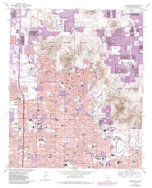
Sunnyslope Topo Map Arizona
To zoom in, hover over the map of Sunnyslope
USGS Topo Quad 33112e1 - 1:24,000 scale
| Topo Map Name: | Sunnyslope |
| USGS Topo Quad ID: | 33112e1 |
| Print Size: | ca. 21 1/4" wide x 27" high |
| Southeast Coordinates: | 33.5° N latitude / 112° W longitude |
| Map Center Coordinates: | 33.5625° N latitude / 112.0625° W longitude |
| U.S. State: | AZ |
| Filename: | o33112e1.jpg |
| Download Map JPG Image: | Sunnyslope topo map 1:24,000 scale |
| Map Type: | Topographic |
| Topo Series: | 7.5´ |
| Map Scale: | 1:24,000 |
| Source of Map Images: | United States Geological Survey (USGS) |
| Alternate Map Versions: |
Sunnyslope AZ 1965, updated 1967 Download PDF Buy paper map Sunnyslope AZ 1965, updated 1975 Download PDF Buy paper map Sunnyslope AZ 1965, updated 1983 Download PDF Buy paper map Sunnyslope AZ 1965, updated 1983 Download PDF Buy paper map Sunnyslope AZ 1971, updated 1972 Download PDF Buy paper map Sunnyslope AZ 2011 Download PDF Buy paper map Sunnyslope AZ 2014 Download PDF Buy paper map |
1:24,000 Topo Quads surrounding Sunnyslope
> Back to 33112e1 at 1:100,000 scale
> Back to 33112a1 at 1:250,000 scale
> Back to U.S. Topo Maps home
Sunnyslope topo map: Gazetteer
Sunnyslope: Airports
Arizona Public Service Company Heliport elevation 381m 1250′Biltmore Golf Course Heliport elevation 378m 1240′
John C Lincoln Helistop elevation 383m 1256′
John C Lincoln Hospital Heliport elevation 384m 1259′
Phoenix Baptist Hospital Heliport elevation 352m 1154′
Pulice Construction Heliport elevation 377m 1236′
The Hotel Westcourt Heliport elevation 379m 1243′
Sunnyslope: Arroyos
Dreamy Draw elevation 378m 1240′Sunnyslope: Canals
Grand Canal elevation 343m 1125′Sunnyslope: Crossings
Peoria Underpass elevation 382m 1253′Sunnyslope: Dams
Dreamy Draw Dam elevation 421m 1381′East Park Dam elevation 410m 1345′
North Mountain Flood Detention Dam Number Three elevation 430m 1410′
North Mountain Flood Detention Dam Number Two A elevation 441m 1446′
West Park Dam elevation 404m 1325′
Sunnyslope: Parks
Acacia Park elevation 395m 1295′Alicia Park elevation 370m 1213′
Altadena Park elevation 426m 1397′
Cave Creek Park elevation 388m 1272′
Granada Park elevation 385m 1263′
Grato Park elevation 452m 1482′
Herberger Park Number Two elevation 374m 1227′
Herberger Park One elevation 377m 1236′
Honan Park Two elevation 376m 1233′
Indian Bend Park elevation 429m 1407′
Monfort Park elevation 394m 1292′
Mountain View Park elevation 391m 1282′
North Mountain Park elevation 628m 2060′
Norton Park elevation 400m 1312′
Palma Park elevation 389m 1276′
Phoenix Mountains Park elevation 760m 2493′
Phoenix Mountains Preserve elevation 528m 1732′
Roadrunner Park elevation 425m 1394′
Royal Palm Park elevation 368m 1207′
Solano Park elevation 349m 1145′
Stoney Mountain Park elevation 434m 1423′
Sumida Park elevation 389m 1276′
Sunnyslope Park elevation 377m 1236′
Tawa Park elevation 342m 1122′
Venturoso Park elevation 431m 1414′
Washington Park elevation 357m 1171′
Zuni Park elevation 354m 1161′
Sunnyslope: Populated Places
Biltmore Gates elevation 383m 1256′Biltmore Greens III elevation 413m 1354′
Biltmore Villas elevation 365m 1197′
Cactus elevation 439m 1440′
Cactus Gardens Mobile Home Park elevation 449m 1473′
Canyon Village elevation 388m 1272′
Chris-Town Travel Trailer and Mobile Home Park elevation 347m 1138′
Citrus Grove Trailer Park elevation 372m 1220′
Claremont Place elevation 369m 1210′
Colony Biltmore IV elevation 366m 1200′
Colony South elevation 400m 1312′
Covered Wagon Mobile Home Park elevation 357m 1171′
Estate Monterra elevation 374m 1227′
Glen Canyon Trailer Park elevation 361m 1184′
Heritage Highlands elevation 412m 1351′
Hi View Mobile Home Park elevation 394m 1292′
Highland Terrace Mobile Home Park elevation 394m 1292′
Holiday Spa Mobile Home Park elevation 415m 1361′
Lake Biltmore Estates elevation 383m 1256′
Lookout Mountain elevation 438m 1437′
Mayflower Terrace elevation 431m 1414′
Mountain View Trailer Court elevation 379m 1243′
New Home Mobile Park elevation 351m 1151′
Oregon Trail Mobile Home Park elevation 370m 1213′
Palmas Royale elevation 369m 1210′
Paradise Valley Oasis elevation 436m 1430′
Peri-Winkle Mobile Home Park elevation 351m 1151′
Rancho San Carlos elevation 432m 1417′
Ridgegate elevation 419m 1374′
Royal Palm Travel Trailer and Mobile Home Park elevation 375m 1230′
Shadow Mountain elevation 437m 1433′
Silver Bell Trailer Park elevation 344m 1128′
Singing Spur Mobile Park elevation 353m 1158′
Skyline Heights elevation 387m 1269′
Stony Mountain Villas elevation 448m 1469′
Sunny Slope Mobile Home Park elevation 378m 1240′
Sunnyslope elevation 385m 1263′
Sunset North elevation 409m 1341′
Taliverde elevation 367m 1204′
The Pointe elevation 397m 1302′
The Preserve elevation 441m 1446′
Thunderbird Valley Number Two elevation 397m 1302′
Villa Novena elevation 353m 1158′
Village on the Lakes elevation 374m 1227′
Wabash Trailer Court elevation 389m 1276′
Welcome Home Mobile Park elevation 351m 1151′
Sunnyslope: Post Offices
Indian School Station Post Office elevation 345m 1131′Northeast Post Office elevation 353m 1158′
Northwest Station Post Office elevation 348m 1141′
Shaw Butte Post Office elevation 393m 1289′
Sunnyslope Post Office elevation 386m 1266′
Washington Post Office elevation 367m 1204′
Sunnyslope: Streams
Cave Creek elevation 373m 1223′Sunnyslope: Summits
Lookout Mountain elevation 618m 2027′Moon Hill elevation 507m 1663′
Moon Mountain elevation 442m 1450′
North Mountain elevation 628m 2060′
Phoenix Mountains elevation 776m 2545′
Piestewa Peak elevation 776m 2545′
Shadow Mountain elevation 586m 1922′
Shaw Butte elevation 0m 0′
Veterans Mountain elevation 580m 1902′
Sunnyslope: Valleys
Paradise Valley elevation 427m 1400′Sunnyslope digital topo map on disk
Buy this Sunnyslope topo map showing relief, roads, GPS coordinates and other geographical features, as a high-resolution digital map file on DVD:


