El Mirage Topo Map Arizona
To zoom in, hover over the map of El Mirage
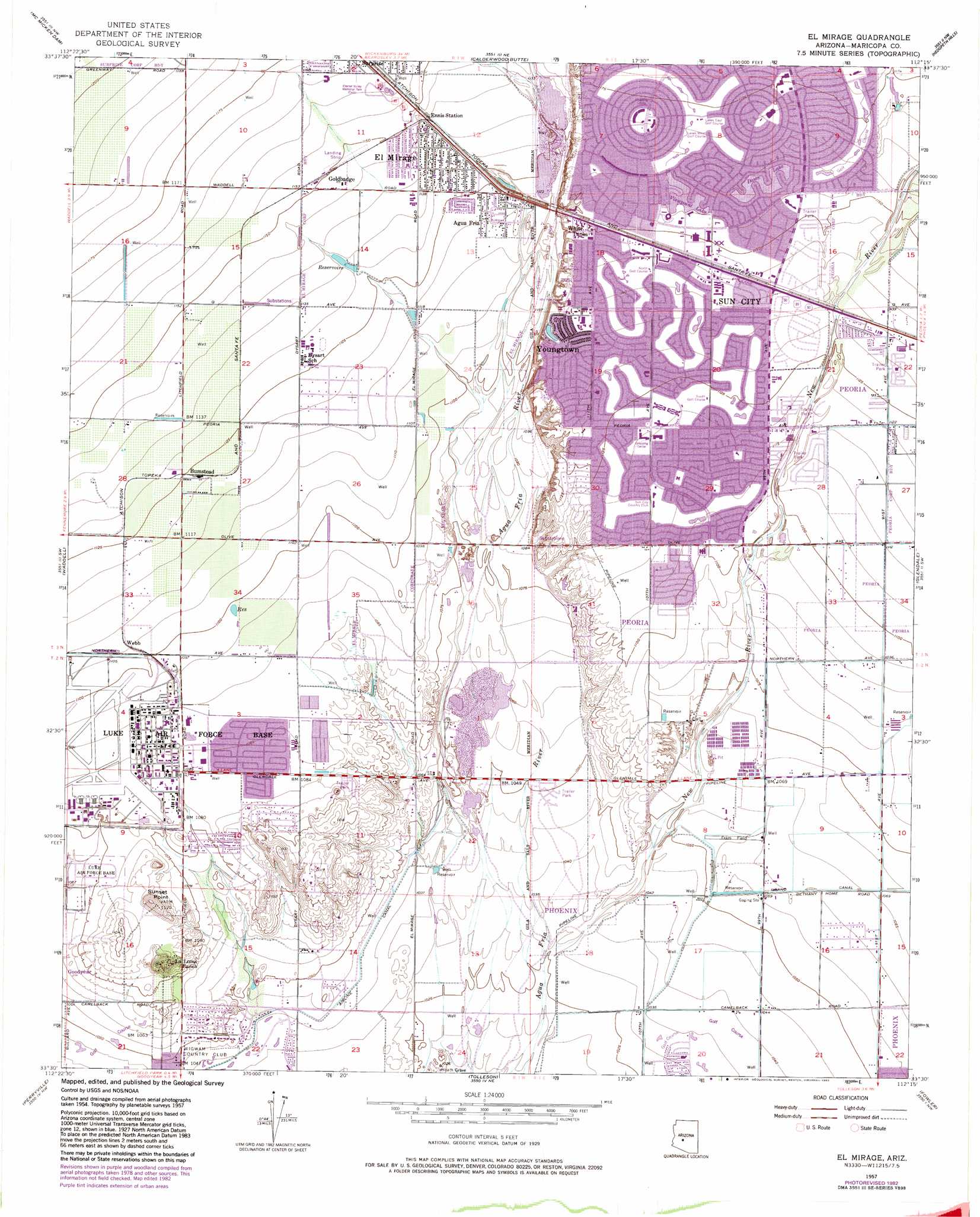
USGS Topo Quad 33112e3 - 1:24,000 scale
| Topo Map Name: | El Mirage |
| USGS Topo Quad ID: | 33112e3 |
| Print Size: | ca. 21 1/4" wide x 27" high |
| Southeast Coordinates: | 33.5° N latitude / 112.25° W longitude |
| Map Center Coordinates: | 33.5625° N latitude / 112.3125° W longitude |
| U.S. State: | AZ |
| Filename: | o33112e3.jpg |
| Download Map JPG Image: | El Mirage topo map 1:24,000 scale |
| Map Type: | Topographic |
| Topo Series: | 7.5´ |
| Map Scale: | 1:24,000 |
| Source of Map Images: | United States Geological Survey (USGS) |
| Alternate Map Versions: |
El Mirage AZ 1957, updated 1958 Download PDF Buy paper map El Mirage AZ 1957, updated 1967 Download PDF Buy paper map El Mirage AZ 1957, updated 1972 Download PDF Buy paper map El Mirage AZ 1957, updated 1977 Download PDF Buy paper map El Mirage AZ 1957, updated 1983 Download PDF Buy paper map El Mirage AZ 1971 Download PDF Buy paper map El Mirage AZ 2011 Download PDF Buy paper map El Mirage AZ 2014 Download PDF Buy paper map |
1:24,000 Topo Quads surrounding El Mirage
Wittmann |
Hieroglyphic Mountains Sw |
Baldy Mountain |
Biscuit Flat |
New River Se |
White Tank Mountains Ne |
Mcmicken Dam |
Calderwood Butte |
Hedgpeth Hills |
Union Hills |
White Tank Mountains |
Waddell |
El Mirage |
Glendale |
Sunnyslope |
Valencia |
Perryville |
Tolleson |
Fowler |
Phoenix |
Buckeye |
Avondale Sw |
Avondale Se |
Laveen |
Lone Butte |
> Back to 33112e1 at 1:100,000 scale
> Back to 33112a1 at 1:250,000 scale
> Back to U.S. Topo Maps home
El Mirage topo map: Gazetteer
El Mirage: Airports
Boswell Memorial Hospital Heliport elevation 351m 1151′Boulais Heliport elevation 323m 1059′
C Andrew Laird Heliport elevation 355m 1164′
El Mirage-Village Square Airport elevation 351m 1151′
Fram Field elevation 322m 1056′
Glendale Municipal Airport elevation 319m 1046′
Litchfield Airport elevation 319m 1046′
Litchfield Park Airport (historical) elevation 318m 1043′
El Mirage: Arroyos
Dale Creek Wash elevation 325m 1066′Dysart Drain Wash elevation 324m 1062′
Lower El Mirage Wash elevation 334m 1095′
North Fork Lower El Mirage Wash elevation 341m 1118′
El Mirage: Canals
Airline Canal elevation 318m 1043′El Mirage: Dams
Litchfield Park Dam elevation 324m 1062′El Mirage: Lakes
Dawn Lake elevation 353m 1158′Maricopa Lake elevation 346m 1135′
Viewpoint Lake elevation 353m 1158′
El Mirage: Parks
Calicke Park elevation 346m 1135′Clubhouse Municipal Park elevation 348m 1141′
El Mirage Baseball Park elevation 348m 1141′
Jobing.com Arena elevation 327m 1072′
Ludden Park elevation 345m 1131′
University of Phoenix Stadium elevation 326m 1069′
El Mirage: Populated Places
Agua Fria elevation 342m 1122′Apollo Mobile Home Park elevation 342m 1122′
Bumstead elevation 343m 1125′
Casa del Sol Resorts Number One elevation 345m 1131′
Chador Mobile Home Park elevation 343m 1125′
Country Greens at Villa de Paz elevation 314m 1030′
Country Meadows elevation 337m 1105′
Dysart (historical) elevation 350m 1148′
El Mirage elevation 349m 1145′
El San Juan Trailer Park elevation 343m 1125′
Goldbadge elevation 351m 1151′
LaLoma Ranch elevation 334m 1095′
Peoria Polynesian Village elevation 344m 1128′
S C Townhouse Mobile Home Estates elevation 340m 1115′
Sun City elevation 348m 1141′
Sun Grove Mobile Home Park elevation 333m 1092′
Sunset Village elevation 346m 1135′
Villa Vista elevation 345m 1131′
Webb elevation 338m 1108′
Westgreen Estates elevation 339m 1112′
White Tanks elevation 351m 1151′
Youngtown elevation 347m 1138′
El Mirage: Post Offices
El Mirage Post Office elevation 344m 1128′Youngtown Post Office elevation 347m 1138′
El Mirage: Streams
New River elevation 313m 1026′El Mirage: Summits
Sunset Point elevation 342m 1122′El Mirage digital topo map on disk
Buy this El Mirage topo map showing relief, roads, GPS coordinates and other geographical features, as a high-resolution digital map file on DVD: