Hedgpeth Hills Topo Map Arizona
To zoom in, hover over the map of Hedgpeth Hills
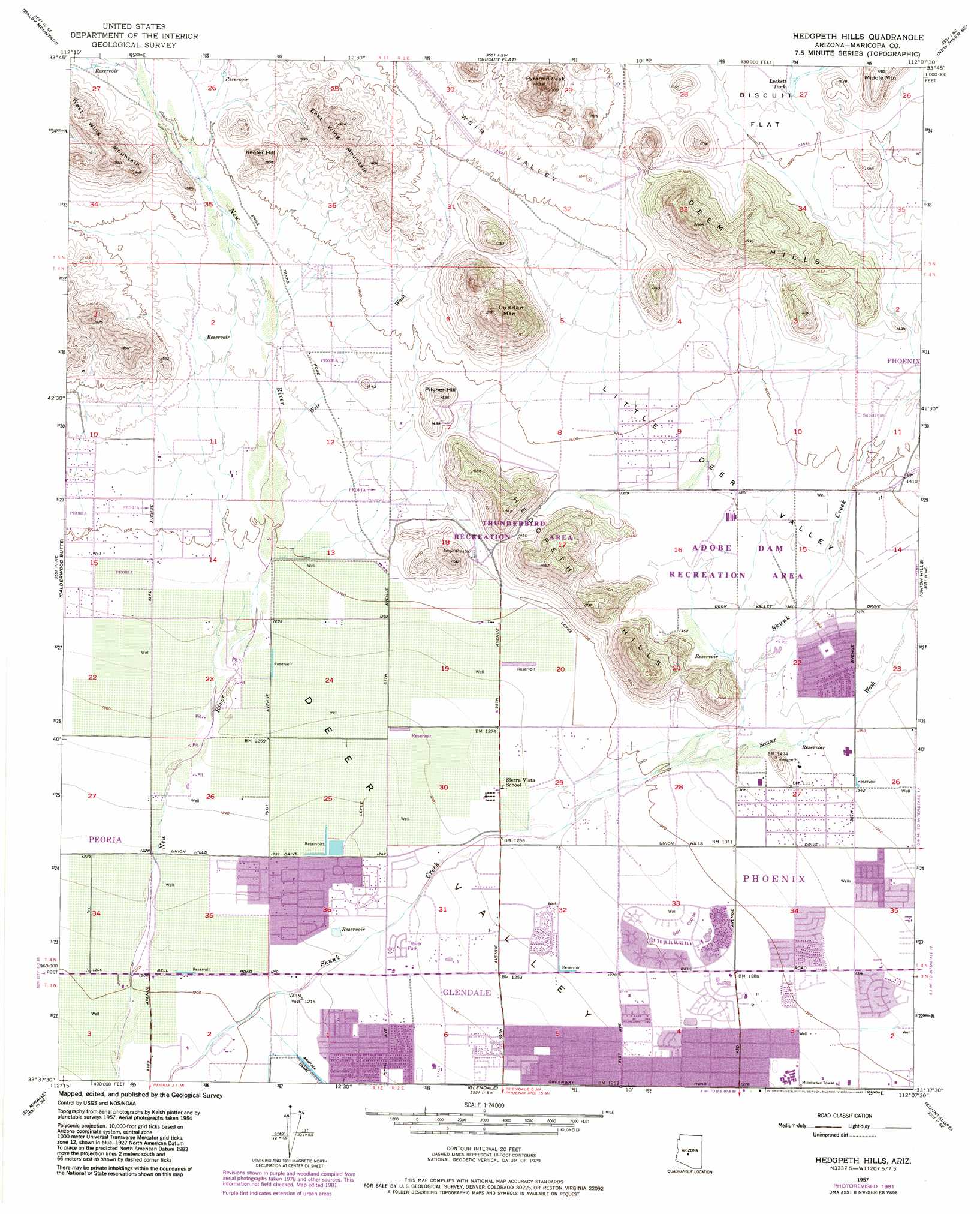
USGS Topo Quad 33112f2 - 1:24,000 scale
| Topo Map Name: | Hedgpeth Hills |
| USGS Topo Quad ID: | 33112f2 |
| Print Size: | ca. 21 1/4" wide x 27" high |
| Southeast Coordinates: | 33.625° N latitude / 112.125° W longitude |
| Map Center Coordinates: | 33.6875° N latitude / 112.1875° W longitude |
| U.S. State: | AZ |
| Filename: | o33112f2.jpg |
| Download Map JPG Image: | Hedgpeth Hills topo map 1:24,000 scale |
| Map Type: | Topographic |
| Topo Series: | 7.5´ |
| Map Scale: | 1:24,000 |
| Source of Map Images: | United States Geological Survey (USGS) |
| Alternate Map Versions: |
Hedgpeth Hills AZ 1957, updated 1958 Download PDF Buy paper map Hedgpeth Hills AZ 1957, updated 1965 Download PDF Buy paper map Hedgpeth Hills AZ 1957, updated 1972 Download PDF Buy paper map Hedgpeth Hills AZ 1957, updated 1977 Download PDF Buy paper map Hedgpeth Hills AZ 1957, updated 1982 Download PDF Buy paper map Hedgpeth Hills AZ 1971, updated 1972 Download PDF Buy paper map Hedgpeth Hills AZ 2011 Download PDF Buy paper map Hedgpeth Hills AZ 2014 Download PDF Buy paper map |
1:24,000 Topo Quads surrounding Hedgpeth Hills
Garfias Mountain |
Governors Peak |
New River |
Daisy Mountain |
New River Mesa |
Hieroglyphic Mountains Sw |
Baldy Mountain |
Biscuit Flat |
New River Se |
Cave Creek |
Mcmicken Dam |
Calderwood Butte |
Hedgpeth Hills |
Union Hills |
Currys Corner |
Waddell |
El Mirage |
Glendale |
Sunnyslope |
Paradise Valley |
Perryville |
Tolleson |
Fowler |
Phoenix |
Tempe |
> Back to 33112e1 at 1:100,000 scale
> Back to 33112a1 at 1:250,000 scale
> Back to U.S. Topo Maps home
Hedgpeth Hills topo map: Gazetteer
Hedgpeth Hills: Airports
Honeywell Incorporated Heliport elevation 385m 1263′McGills Ultralight Field elevation 413m 1354′
Hedgpeth Hills: Dams
Adobe Dam elevation 416m 1364′Hedgpeth Hills: Parks
Adobe Dam Regional Park elevation 418m 1371′Chapparal Park elevation 385m 1263′
Conocido Park elevation 401m 1315′
Sunburst Paradise Park elevation 389m 1276′
Thunderbird Park elevation 461m 1512′
Hedgpeth Hills: Populated Places
Amberwood North elevation 404m 1325′Arrowhead Ranch elevation 387m 1269′
Autumn Ridge elevation 399m 1309′
Brandywine elevation 398m 1305′
Canyon View elevation 400m 1312′
Chaparral elevation 386m 1266′
College Park elevation 380m 1246′
Deer Valley elevation 419m 1374′
Desert Pines elevation 397m 1302′
Dunhill Place elevation 394m 1292′
Lexington Place elevation 377m 1236′
Morado Encanto elevation 405m 1328′
Overland Trail elevation 397m 1302′
Parkview Estates elevation 425m 1394′
Parkview North elevation 394m 1292′
Peacock Village elevation 372m 1220′
Pioneer Estates elevation 386m 1266′
Rancho Encanto elevation 400m 1312′
Saddlehorn Ranch elevation 383m 1256′
San Gabriel elevation 397m 1302′
Shadow Hills elevation 381m 1250′
Suncrest Villas West elevation 408m 1338′
Sunset Vista elevation 385m 1263′
Union Hills Manor elevation 406m 1332′
Verde Real elevation 390m 1279′
Woodridge VI elevation 394m 1292′
Hedgpeth Hills: Post Offices
Arrowhead Post Office elevation 390m 1279′Hedgpeth Hills: Reservoirs
Lockett Tank elevation 464m 1522′Hedgpeth Hills: Streams
Scatter Wash elevation 0m 0′Weir Wash elevation 403m 1322′
Hedgpeth Hills: Summits
Deem Hills elevation 563m 1847′East Wing Mountain elevation 584m 1916′
Hedgpeth Hills elevation 473m 1551′
Keefer Hill elevation 507m 1663′
Ludden Mountain elevation 669m 2194′
Middle Mountain elevation 542m 1778′
Pilcher Hill elevation 482m 1581′
Pyramid Peak elevation 681m 2234′
West Wing Mountain elevation 580m 1902′
Hedgpeth Hills: Valleys
Little Deer Valley elevation 421m 1381′Weir Valley elevation 464m 1522′
Hedgpeth Hills digital topo map on disk
Buy this Hedgpeth Hills topo map showing relief, roads, GPS coordinates and other geographical features, as a high-resolution digital map file on DVD: