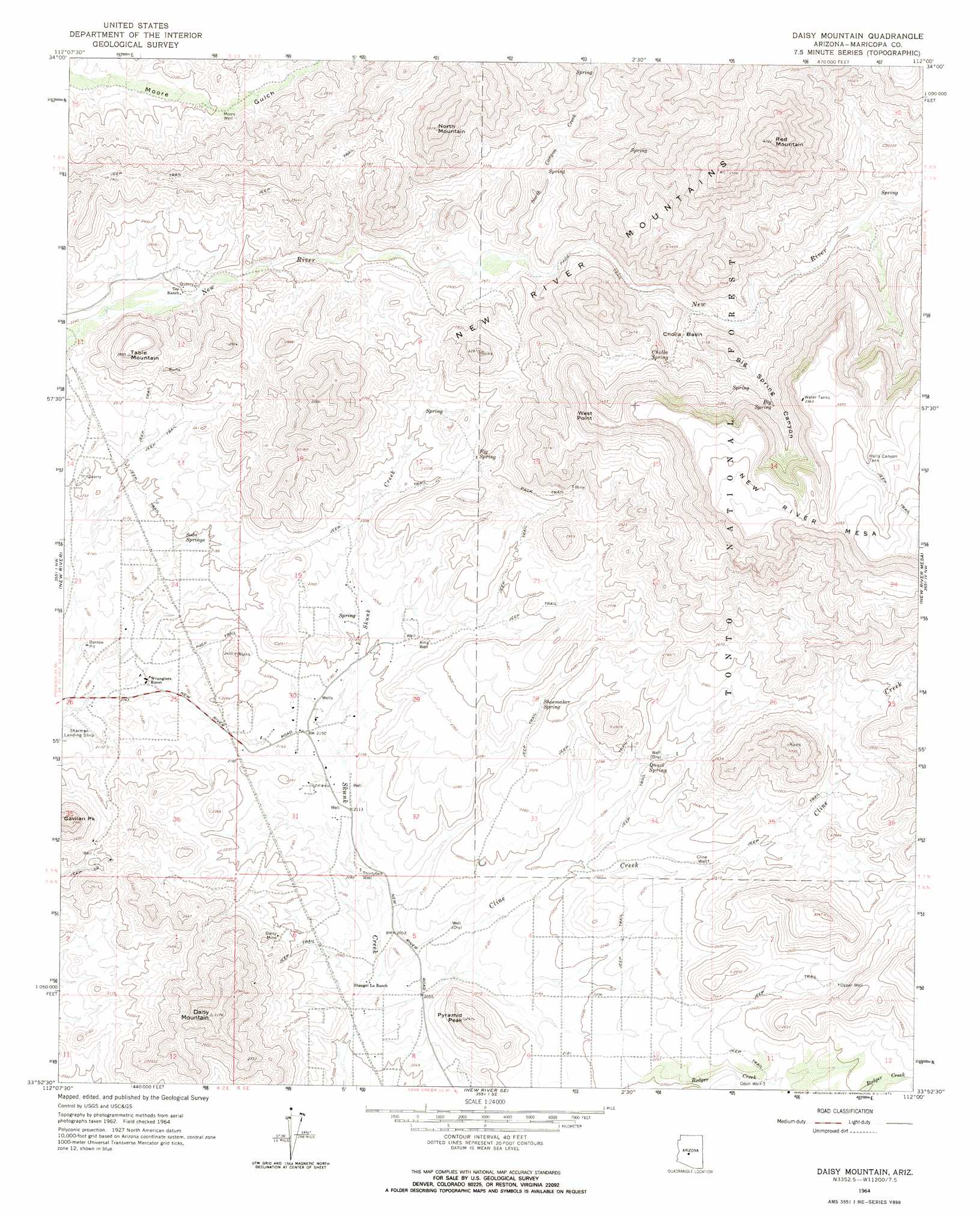
Daisy Mountain Topo Map Arizona
To zoom in, hover over the map of Daisy Mountain
USGS Topo Quad 33112h1 - 1:24,000 scale
| Topo Map Name: | Daisy Mountain |
| USGS Topo Quad ID: | 33112h1 |
| Print Size: | ca. 21 1/4" wide x 27" high |
| Southeast Coordinates: | 33.875° N latitude / 112° W longitude |
| Map Center Coordinates: | 33.9375° N latitude / 112.0625° W longitude |
| U.S. State: | AZ |
| Filename: | o33112h1.jpg |
| Download Map JPG Image: | Daisy Mountain topo map 1:24,000 scale |
| Map Type: | Topographic |
| Topo Series: | 7.5´ |
| Map Scale: | 1:24,000 |
| Source of Map Images: | United States Geological Survey (USGS) |
| Alternate Map Versions: |
Daisy Mountain AZ 1964, updated 1965 Download PDF Buy paper map Daisy Mountain AZ 1964, updated 1965 Download PDF Buy paper map Daisy Mountain AZ 1964, updated 1972 Download PDF Buy paper map Daisy Mountain AZ 1964, updated 1972 Download PDF Buy paper map Daisy Mountain AZ 2004, updated 2006 Download PDF Buy paper map Daisy Mountain AZ 2011 Download PDF Buy paper map Daisy Mountain AZ 2014 Download PDF Buy paper map |
| FStopo: | US Forest Service topo Daisy Mountain is available: Download FStopo PDF Download FStopo TIF |
1:24,000 Topo Quads surrounding Daisy Mountain
Crown King |
Bumble Bee |
Joes Hill |
Brooklyn Peak |
Bloody Basin |
Columbia |
Black Canyon City |
Squaw Creek Mesa |
Cooks Mesa |
Rover Peak |
Governors Peak |
New River |
Daisy Mountain |
New River Mesa |
Humboldt Mountain |
Baldy Mountain |
Biscuit Flat |
New River Se |
Cave Creek |
Wildcat Hill |
Calderwood Butte |
Hedgpeth Hills |
Union Hills |
Currys Corner |
Mcdowell Peak |
> Back to 33112e1 at 1:100,000 scale
> Back to 33112a1 at 1:250,000 scale
> Back to U.S. Topo Maps home
Daisy Mountain topo map: Gazetteer
Daisy Mountain: Airports
Sharman Landing Strip elevation 630m 2066′Daisy Mountain: Basins
Cholla Basin elevation 843m 2765′Daisy Mountain: Cliffs
West Point elevation 1087m 3566′Daisy Mountain: Mines
Daisy Mine elevation 686m 2250′Daisy Mountain: Populated Places
Wranglers Roost elevation 635m 2083′Daisy Mountain: Reservoirs
Hells Canyon Tank elevation 1218m 3996′Daisy Mountain: Springs
Big Spring elevation 988m 3241′Cholla Spring elevation 883m 2896′
Fig Spring elevation 771m 2529′
Quail Spring elevation 717m 2352′
Shoemaker Spring elevation 706m 2316′
Soda Springs elevation 664m 2178′
Daisy Mountain: Streams
Cline Creek elevation 610m 2001′East Fork North Canyon Creek elevation 863m 2831′
North Canyon Creek elevation 756m 2480′
Daisy Mountain: Summits
Daisy Mountain elevation 958m 3143′Gavilan Peak elevation 877m 2877′
North Mountain elevation 1150m 3772′
Pyramid Peak elevation 791m 2595′
Red Mountain elevation 1428m 4685′
Table Mountain elevation 880m 2887′
Daisy Mountain: Valleys
Big Spring Canyon elevation 812m 2664′Daisy Mountain: Wells
Cline Well elevation 712m 2335′King Well elevation 683m 2240′
Moore Well elevation 676m 2217′
Odell Well elevation 693m 2273′
Thirtytwo Well elevation 634m 2080′
Upper Well elevation 764m 2506′
Daisy Mountain digital topo map on disk
Buy this Daisy Mountain topo map showing relief, roads, GPS coordinates and other geographical features, as a high-resolution digital map file on DVD: