Garfias Mountain Topo Map Arizona
To zoom in, hover over the map of Garfias Mountain
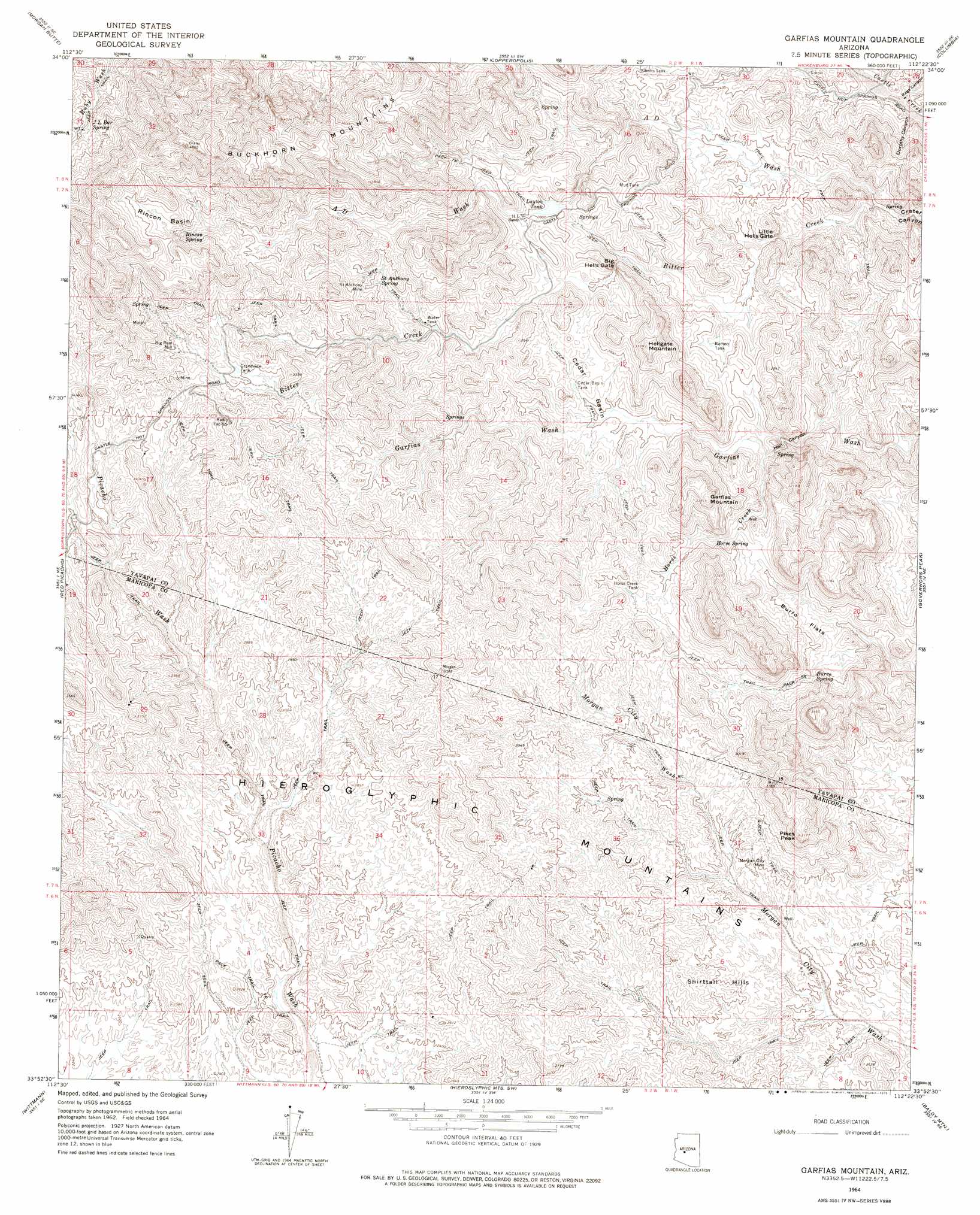
USGS Topo Quad 33112h4 - 1:24,000 scale
| Topo Map Name: | Garfias Mountain |
| USGS Topo Quad ID: | 33112h4 |
| Print Size: | ca. 21 1/4" wide x 27" high |
| Southeast Coordinates: | 33.875° N latitude / 112.375° W longitude |
| Map Center Coordinates: | 33.9375° N latitude / 112.4375° W longitude |
| U.S. State: | AZ |
| Filename: | o33112h4.jpg |
| Download Map JPG Image: | Garfias Mountain topo map 1:24,000 scale |
| Map Type: | Topographic |
| Topo Series: | 7.5´ |
| Map Scale: | 1:24,000 |
| Source of Map Images: | United States Geological Survey (USGS) |
| Alternate Map Versions: |
Garfias Mountain AZ 1964, updated 1965 Download PDF Buy paper map Garfias Mountain AZ 1964, updated 1975 Download PDF Buy paper map Garfias Mountain AZ 1964, updated 1975 Download PDF Buy paper map Garfias Mountain AZ 2011 Download PDF Buy paper map Garfias Mountain AZ 2014 Download PDF Buy paper map |
1:24,000 Topo Quads surrounding Garfias Mountain
Yarnell |
Wagoner |
Minnehaha |
Crown King |
Bumble Bee |
Sam Powell Peak |
Morgan Butte |
Copperopolis |
Columbia |
Black Canyon City |
Wickenburg |
Red Picacho |
Garfias Mountain |
Governors Peak |
New River |
Wickenburg Sw |
Wittmann |
Hieroglyphic Mountains Sw |
Baldy Mountain |
Biscuit Flat |
Daggs Tank |
White Tank Mountains Ne |
Mcmicken Dam |
Calderwood Butte |
Hedgpeth Hills |
> Back to 33112e1 at 1:100,000 scale
> Back to 33112a1 at 1:250,000 scale
> Back to U.S. Topo Maps home
Garfias Mountain topo map: Gazetteer
Garfias Mountain: Basins
Cedar Basin elevation 821m 2693′Rincon Basin elevation 1135m 3723′
Garfias Mountain: Flats
Burro Flats elevation 780m 2559′Garfias Mountain: Gaps
Big Hells Gate elevation 814m 2670′Hell Canyon elevation 718m 2355′
Little Hells Gate elevation 730m 2395′
Garfias Mountain: Mines
Morgan City Mine elevation 747m 2450′Saint Anthony Mine elevation 0m 0′
Garfias Mountain: Populated Places
Big Reef Mill elevation 1035m 3395′Garfias Mountain: Ranges
Hieroglyphic Mountains elevation 966m 3169′Garfias Mountain: Reservoirs
Alberts Tank elevation 763m 2503′Cedar Basin Tank elevation 802m 2631′
Grandview Tank elevation 981m 3218′
Horse Creek Tank elevation 876m 2874′
Layton Tank elevation 843m 2765′
Mud Tank elevation 840m 2755′
Ramon Tank elevation 772m 2532′
Garfias Mountain: Springs
Burro Spring elevation 794m 2604′Cross F Spring elevation 842m 2762′
Horse Spring elevation 832m 2729′
J L Bar Spring elevation 1055m 3461′
Rincon Spring elevation 1067m 3500′
Saint Anthony Spring elevation 0m 0′
Garfias Mountain: Streams
A D Wash elevation 671m 2201′Horse Creek elevation 739m 2424′
Garfias Mountain: Summits
Buckhorn Mountains elevation 1206m 3956′Garfias Mountain elevation 1027m 3369′
Hellgate Mountain elevation 1007m 3303′
Pikes Peak elevation 953m 3126′
Shirttail Hills elevation 0m 0′
Garfias Mountain: Valleys
Dorothy Canyon elevation 629m 2063′Rags Canyon elevation 634m 2080′
Garfias Mountain digital topo map on disk
Buy this Garfias Mountain topo map showing relief, roads, GPS coordinates and other geographical features, as a high-resolution digital map file on DVD: