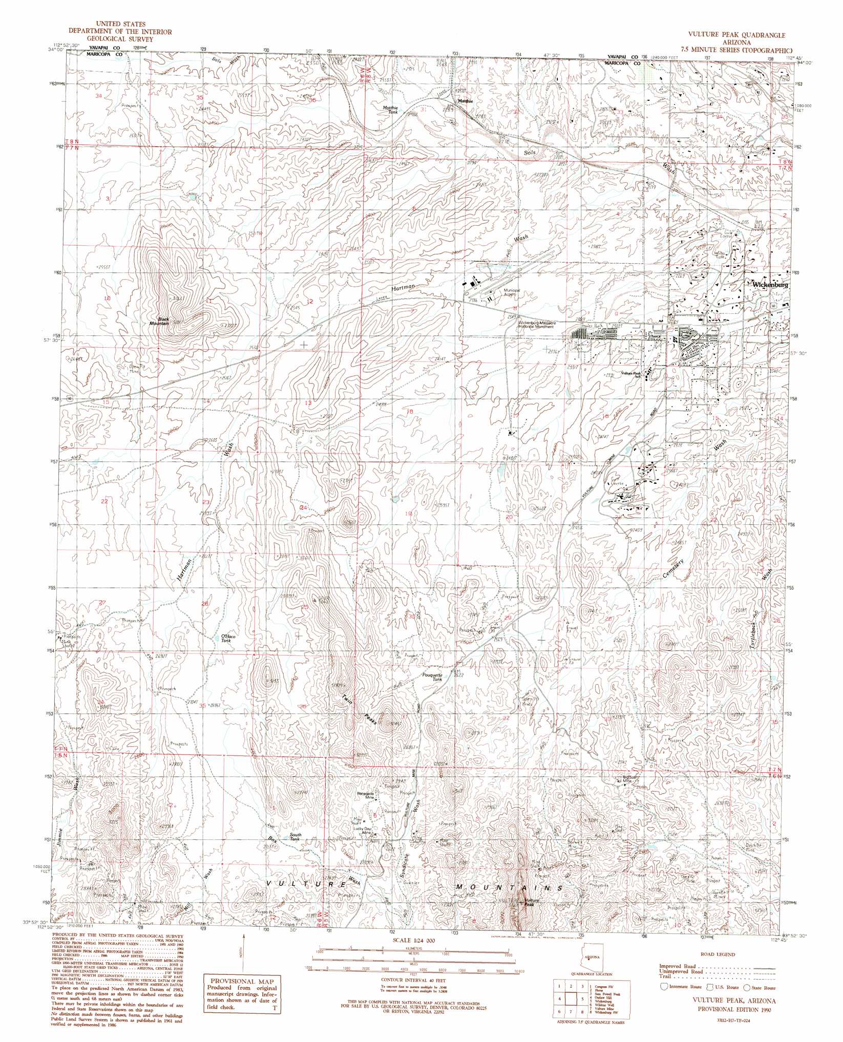
Vulture Peak Topo Map Arizona
To zoom in, hover over the map of Vulture Peak
USGS Topo Quad 33112h7 - 1:24,000 scale
| Topo Map Name: | Vulture Peak |
| USGS Topo Quad ID: | 33112h7 |
| Print Size: | ca. 21 1/4" wide x 27" high |
| Southeast Coordinates: | 33.875° N latitude / 112.75° W longitude |
| Map Center Coordinates: | 33.9375° N latitude / 112.8125° W longitude |
| U.S. State: | AZ |
| Filename: | o33112h7.jpg |
| Download Map JPG Image: | Vulture Peak topo map 1:24,000 scale |
| Map Type: | Topographic |
| Topo Series: | 7.5´ |
| Map Scale: | 1:24,000 |
| Source of Map Images: | United States Geological Survey (USGS) |
| Alternate Map Versions: |
Vulture Peak AZ 1990, updated 1990 Download PDF Buy paper map Vulture Peak AZ 1990, updated 1990 Download PDF Buy paper map Vulture Peak AZ 2011 Download PDF Buy paper map Vulture Peak AZ 2014 Download PDF Buy paper map |
1:24,000 Topo Quads surrounding Vulture Peak
Date Creek Ranch |
O'Neill Pass |
Congress |
Yarnell |
Wagoner |
Date Creek Ranch Se |
Congress Sw |
Flores |
Sam Powell Peak |
Morgan Butte |
Forepaugh Peak |
Outlaw Hill |
Vulture Peak |
Wickenburg |
Red Picacho |
Black Butte |
Wildcat Well |
Vulture Mine |
Wickenburg Sw |
Wittmann |
Hummingbird Spring |
Belmont Mountain |
Star Well |
Daggs Tank |
White Tank Mountains Ne |
> Back to 33112e1 at 1:100,000 scale
> Back to 33112a1 at 1:250,000 scale
> Back to U.S. Topo Maps home
Vulture Peak topo map: Gazetteer
Vulture Peak: Airports
Flying E Guest Ranch Airport elevation 732m 2401′Ranchos de los Caballeros Airport elevation 739m 2424′
Wickenburg Municipal Airport elevation 721m 2365′
Vulture Peak: Mines
Big Spar Mine elevation 803m 2634′Lucky Day Mine elevation 805m 2641′
Renegade Mine elevation 810m 2657′
Twin Buzzards Mine elevation 769m 2522′
Vulture Peak: Parks
Wickenburg Massacre Historical Monument elevation 716m 2349′Vulture Peak: Populated Places
Matthie elevation 707m 2319′Vulture Peak: Ranges
Vulture Mountains elevation 953m 3126′Vulture Peak: Reservoirs
Flying E Tank elevation 708m 2322′Matthie Tank elevation 704m 2309′
O'Haco Tank elevation 814m 2670′
Pouquette Tank elevation 804m 2637′
South Tank elevation 802m 2631′
Yucca Tank elevation 757m 2483′
Vulture Peak: Streams
Flying E Wash elevation 651m 2135′Hartman Wash elevation 670m 2198′
Holly Wash elevation 724m 2375′
Twin Peaks Wash elevation 735m 2411′
Yucca Flat Wash elevation 708m 2322′
Vulture Peak: Summits
Black Mountain elevation 896m 2939′Twin Peaks elevation 1013m 3323′
Vulture Peak elevation 1102m 3615′
Vulture Peak digital topo map on disk
Buy this Vulture Peak topo map showing relief, roads, GPS coordinates and other geographical features, as a high-resolution digital map file on DVD: