Courthouse Well Topo Map Arizona
To zoom in, hover over the map of Courthouse Well
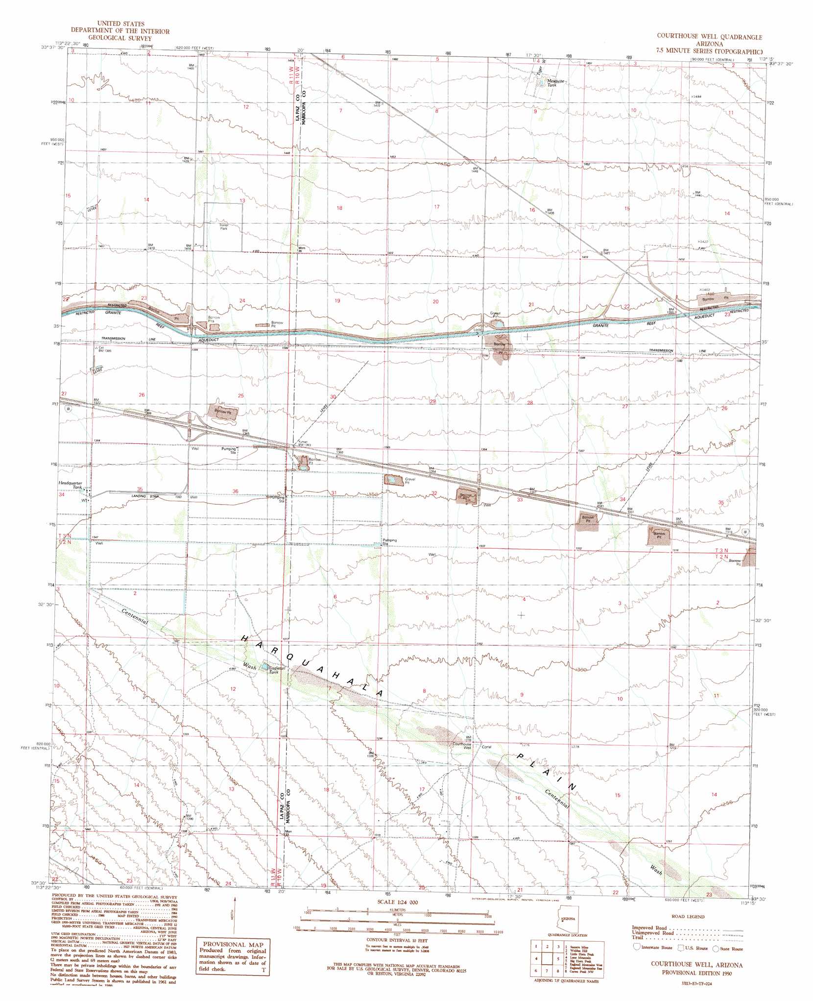
USGS Topo Quad 33113e3 - 1:24,000 scale
| Topo Map Name: | Courthouse Well |
| USGS Topo Quad ID: | 33113e3 |
| Print Size: | ca. 21 1/4" wide x 27" high |
| Southeast Coordinates: | 33.5° N latitude / 113.25° W longitude |
| Map Center Coordinates: | 33.5625° N latitude / 113.3125° W longitude |
| U.S. State: | AZ |
| Filename: | o33113e3.jpg |
| Download Map JPG Image: | Courthouse Well topo map 1:24,000 scale |
| Map Type: | Topographic |
| Topo Series: | 7.5´ |
| Map Scale: | 1:24,000 |
| Source of Map Images: | United States Geological Survey (USGS) |
| Alternate Map Versions: |
Courthouse Well AZ 1990, updated 1990 Download PDF Buy paper map Courthouse Well AZ 2011 Download PDF Buy paper map Courthouse Well AZ 2014 Download PDF Buy paper map |
1:24,000 Topo Quads surrounding Courthouse Well
Salome |
Socorro Peak |
Harquahala Mountain |
Tiger Well |
Black Butte |
Harrisburg Valley |
Socorro Mine |
Weldon Hill |
Little Horn Peak |
Hummingbird Spring |
Hope Se |
Lone Mountain |
Courthouse Well |
Big Horn Peak |
Burnt Mountain |
Little Horn Mountains Ne |
Eagletail Mountains West |
Eagletail Mountains East |
Cortez Peak Nw |
Saddle Mountain |
Little Horn Mountains Se |
Nottbusch Butte |
Columbus Peak |
Cortez Peak |
Fourth Of July Butte |
> Back to 33113e1 at 1:100,000 scale
> Back to 33112a1 at 1:250,000 scale
> Back to U.S. Topo Maps home
Courthouse Well topo map: Gazetteer
Courthouse Well: Plains
Harquahala Plain elevation 436m 1430′Courthouse Well: Populated Places
Centennial elevation 421m 1381′Courthouse Well: Reservoirs
Eagletail Tank elevation 403m 1322′Headquarter Tank elevation 414m 1358′
Mesquite Tank elevation 452m 1482′
Courthouse Well: Streams
Tiger Wash elevation 427m 1400′Courthouse Well: Wells
Courthouse Well elevation 390m 1279′Courthouse Well digital topo map on disk
Buy this Courthouse Well topo map showing relief, roads, GPS coordinates and other geographical features, as a high-resolution digital map file on DVD: