Harcuvar Peak Topo Map Arizona
To zoom in, hover over the map of Harcuvar Peak
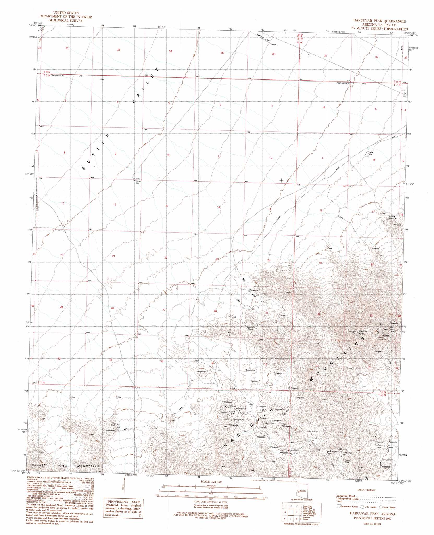
USGS Topo Quad 33113h6 - 1:24,000 scale
| Topo Map Name: | Harcuvar Peak |
| USGS Topo Quad ID: | 33113h6 |
| Print Size: | ca. 21 1/4" wide x 27" high |
| Southeast Coordinates: | 33.875° N latitude / 113.625° W longitude |
| Map Center Coordinates: | 33.9375° N latitude / 113.6875° W longitude |
| U.S. State: | AZ |
| Filename: | o33113h6.jpg |
| Download Map JPG Image: | Harcuvar Peak topo map 1:24,000 scale |
| Map Type: | Topographic |
| Topo Series: | 7.5´ |
| Map Scale: | 1:24,000 |
| Source of Map Images: | United States Geological Survey (USGS) |
| Alternate Map Versions: |
Harcuvar Peak AZ 1990, updated 1990 Download PDF Buy paper map Harcuvar Peak AZ 2011 Download PDF Buy paper map Harcuvar Peak AZ 2014 Download PDF Buy paper map |
1:24,000 Topo Quads surrounding Harcuvar Peak
Planet |
Swansea |
Reid Valley |
Alamo Dam |
Smith Peak Nw |
Powerline Well |
Butler Pass |
Butler Well |
Alamo Dam Se |
E C P Peak |
Bouse Hills West |
Bouse Hills East |
Harcuvar Peak |
Cunningham Pass |
Webber Canyon |
Utting |
East Of Utting |
Harcuvar |
Salome |
Socorro Peak |
Bear Hills |
Vicksburg |
Hope |
Harrisburg Valley |
Socorro Mine |
> Back to 33113e1 at 1:100,000 scale
> Back to 33112a1 at 1:250,000 scale
> Back to U.S. Topo Maps home
Harcuvar Peak topo map: Gazetteer
Harcuvar Peak: Gaps
Cottonwood Pass elevation 827m 2713′Harcuvar Peak: Mines
Doland Mine elevation 765m 2509′Golden Treasure Mine elevation 622m 2040′
Sheba Mine elevation 0m 0′
Harcuvar Peak: Summits
Harcuvar Peak elevation 1402m 4599′Harcuvar Peak digital topo map on disk
Buy this Harcuvar Peak topo map showing relief, roads, GPS coordinates and other geographical features, as a high-resolution digital map file on DVD: