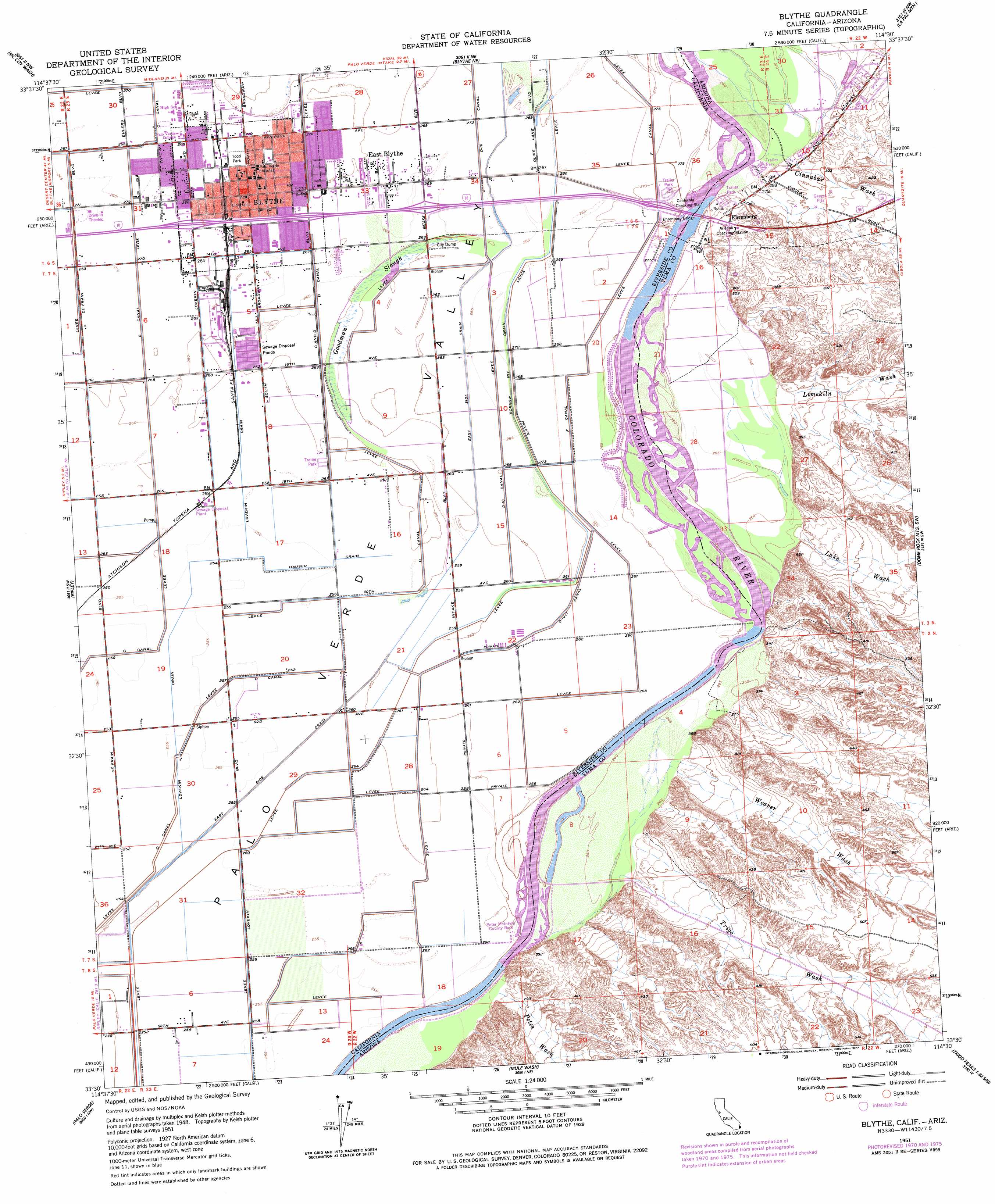
Blythe Topo Map California
To zoom in, hover over the map of Blythe
USGS Topo Quad 33114e5 - 1:24,000 scale
| Topo Map Name: | Blythe |
| USGS Topo Quad ID: | 33114e5 |
| Print Size: | ca. 21 1/4" wide x 27" high |
| Southeast Coordinates: | 33.5° N latitude / 114.5° W longitude |
| Map Center Coordinates: | 33.5625° N latitude / 114.5625° W longitude |
| U.S. States: | CA, AZ |
| Filename: | o33114e5.jpg |
| Download Map JPG Image: | Blythe topo map 1:24,000 scale |
| Map Type: | Topographic |
| Topo Series: | 7.5´ |
| Map Scale: | 1:24,000 |
| Source of Map Images: | United States Geological Survey (USGS) |
| Alternate Map Versions: |
Blythe CA 1951, updated 1952 Download PDF Buy paper map Blythe CA 1951, updated 1956 Download PDF Buy paper map Blythe CA 1951, updated 1971 Download PDF Buy paper map Blythe CA 1951, updated 1971 Download PDF Buy paper map Blythe CA 1951, updated 1977 Download PDF Buy paper map Blythe CA 1951, updated 1977 Download PDF Buy paper map Blythe CA 1970, updated 1975 Download PDF Buy paper map Blythe CA 2012 Download PDF Buy paper map Blythe CA 2015 Download PDF Buy paper map |
1:24,000 Topo Quads surrounding Blythe
Inca |
Big Maria Mountains Sw |
Big Maria Mountains Se |
Moon Mountain |
Moon Mountain Se |
Mccoy Peak |
Mccoy Wash |
Blythe Ne |
La Paz Mountain |
Middle Camp Mountain |
Roosevelt Mine |
Ripley |
Blythe |
Dome Rock Mountains Sw |
Cunningham Mountain |
Thumb Peak |
Palo Verde |
Mule Wash |
North Trigo Peaks |
Trigo Pass |
Palo Verde Peak |
Cibola |
Cibola Se |
Mohave Peak |
Tweed Mine |
> Back to 33114e1 at 1:100,000 scale
> Back to 33114a1 at 1:250,000 scale
> Back to U.S. Topo Maps home
Blythe topo map: Gazetteer
Blythe: Airports
Blythe Service Center Heliport elevation 81m 265′Cyr Aviation Airport elevation 80m 262′
Blythe: Bends
Deepwater Bend elevation 79m 259′Blythe: Bridges
Ehrenberg Bridge elevation 78m 255′Ehrenberg Bridge elevation 78m 255′
Blythe: Canals
C Canal elevation 83m 272′D Canal elevation 81m 265′
D-10 Canal elevation 82m 269′
D-10-11 canal elevation 80m 262′
East Side Drain elevation 81m 265′
F Canal elevation 83m 272′
Hauser Drain elevation 78m 255′
Lovekin Drain elevation 78m 255′
Blythe: Guts
Goodman Slough elevation 80m 262′Blythe: Parks
Appleby Park elevation 82m 269′Goose Flats Park elevation 80m 262′
Miller Park elevation 81m 265′
Peter Mclntyre County Park elevation 79m 259′
Sungold Park elevation 81m 265′
Todd Park elevation 83m 272′
Blythe: Populated Places
Blythe elevation 83m 272′Blythe Marina Mobile Estates elevation 80m 262′
East Blythe elevation 82m 269′
Ehrenberg elevation 93m 305′
Miller Farms elevation 79m 259′
Olive City (historical) elevation 81m 265′
Blythe: Post Offices
Blythe Post Office elevation 82m 269′Blythe: Streams
Ehrenberg Wash elevation 81m 265′Lake Wash elevation 89m 291′
Limekiln Wash elevation 85m 278′
Petes Wash elevation 82m 269′
Trigo Wash elevation 82m 269′
Weaver Wash elevation 83m 272′
Blythe: Valleys
Cinnabar Wash elevation 109m 357′Parker Valley elevation 81m 265′
Blythe digital topo map on disk
Buy this Blythe topo map showing relief, roads, GPS coordinates and other geographical features, as a high-resolution digital map file on DVD: