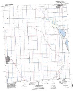
Westmorland East Topo Map California
To zoom in, hover over the map of Westmorland East
USGS Topo Quad 33115a5 - 1:24,000 scale
| Topo Map Name: | Westmorland East |
| USGS Topo Quad ID: | 33115a5 |
| Print Size: | ca. 21 1/4" wide x 27" high |
| Southeast Coordinates: | 33° N latitude / 115.5° W longitude |
| Map Center Coordinates: | 33.0625° N latitude / 115.5625° W longitude |
| U.S. State: | CA |
| Filename: | o33115a5.jpg |
| Download Map JPG Image: | Westmorland East topo map 1:24,000 scale |
| Map Type: | Topographic |
| Topo Series: | 7.5´ |
| Map Scale: | 1:24,000 |
| Source of Map Images: | United States Geological Survey (USGS) |
| Alternate Map Versions: |
Westmorland CA 1956, updated 1957 Download PDF Buy paper map Westmorland CA 1956, updated 1974 Download PDF Buy paper map Westmorland CA 1956, updated 1980 Download PDF Buy paper map Westmorland East CA 1992, updated 1995 Download PDF Buy paper map Westmorland East CA 2012 Download PDF Buy paper map Westmorland East CA 2015 Download PDF Buy paper map |
1:24,000 Topo Quads surrounding Westmorland East
> Back to 33115a1 at 1:100,000 scale
> Back to 33114a1 at 1:250,000 scale
> Back to U.S. Topo Maps home
Westmorland East topo map: Gazetteer
Westmorland East: Areas
Imperial Waterfowl Management Area elevation -54m -178′Westmorland East: Canals
Bailey Drain elevation -49m -161′Baughman Drain elevation -49m -161′
Baughman Drain Number One elevation -48m -158′
Best Canal elevation -43m -142′
Best Drain elevation -46m -151′
C Lateral West elevation -54m -178′
Cole Drain elevation -45m -148′
Gerrard Drain elevation -59m -194′
Lack Lateral elevation -46m -151′
Lateral One elevation -59m -194′
Livesley Drain elevation -43m -142′
Main Canal elevation -41m -135′
Main Spruce Canal elevation -40m -132′
Main Spruce Canal elevation -48m -158′
Marsh Lateral elevation -42m -138′
Meserve Drain elevation -50m -165′
New Spruce Canal elevation -39m -128′
Oakley Canal elevation -42m -138′
Raymond Drain elevation -56m -184′
Reed Fifteen Drain elevation -60m -197′
Reed Lateral Fifteen elevation -60m -197′
Riley Eleven Drain elevation -60m -197′
Riley Lateral Eleven elevation -60m -197′
Riley Lateral Nine elevation -59m -194′
Rockwood Canal elevation -46m -151′
Rockwood Drain elevation -55m -181′
Rockwood Lateral B elevation -52m -171′
Rockwood Lateral Seven elevation -49m -161′
Shellenberger Drain elevation -43m -142′
Smilax Canal elevation -37m -122′
Smilax Lateral One elevation -38m -125′
Spruce Drain elevation -38m -125′
Spruce Drain No 2 elevation -38m -125′
Spruce Drain Number Eighteen elevation -41m -135′
Spruce Drain Number One elevation -43m -142′
Spruce Four Drain elevation -51m -168′
Spruce Lateral Five elevation -43m -142′
Spruce Lateral Four elevation -42m -138′
Spruce Lateral One elevation -39m -128′
Spruce Lateral Three elevation -41m -135′
Spruce One Drain elevation -41m -135′
Spruce Three Drain elevation -42m -138′
Stahl Drain elevation -44m -145′
Tamarack Canal elevation -45m -148′
Tamarack Drain elevation -46m -151′
Timothy Drain elevation -47m -155′
Timothy Lateral elevation -51m -168′
Trifolium Five Drain South elevation -54m -178′
Trifolium Five Drain South elevation -46m -151′
Trifolium Four Drain elevation -41m -135′
Trifolium Four Drain elevation -47m -155′
Trifolium Lateral Five North elevation -55m -181′
Trifolium Lateral Five South elevation -46m -151′
Trifolium Lateral Four elevation -45m -148′
Trifolium Lateral One elevation -40m -132′
Trifolium Lateral Three elevation -47m -155′
Trifolium Lateral Two elevation -43m -142′
Trifolium One Drain elevation -41m -135′
Trifolium Six Drain elevation -60m -197′
Vail Drain elevation -60m -197′
Vail Drain Spur elevation -58m -191′
Vail One Drain elevation -60m -197′
Westmorland East: Dams
North End Dam elevation -57m -188′Westmorland East: Lakes
Finney Lake elevation -53m -174′Ramer Lake elevation -53m -174′
Westmorland East: Parks
Westmorland City Park elevation -49m -161′Westmorland East: Populated Places
Bernice (historical) elevation -52m -171′Fondo elevation -62m -204′
Hovley elevation -42m -138′
Rockwood elevation -47m -155′
Shamrock (historical) elevation -60m -197′
Verdant elevation -60m -197′
Westmorland elevation -50m -165′
Westmorland East: Post Offices
Westmorland Post Office elevation -49m -161′Westmorland East digital topo map on disk
Buy this Westmorland East topo map showing relief, roads, GPS coordinates and other geographical features, as a high-resolution digital map file on DVD:


