Pinto Mountain Topo Map California
To zoom in, hover over the map of Pinto Mountain
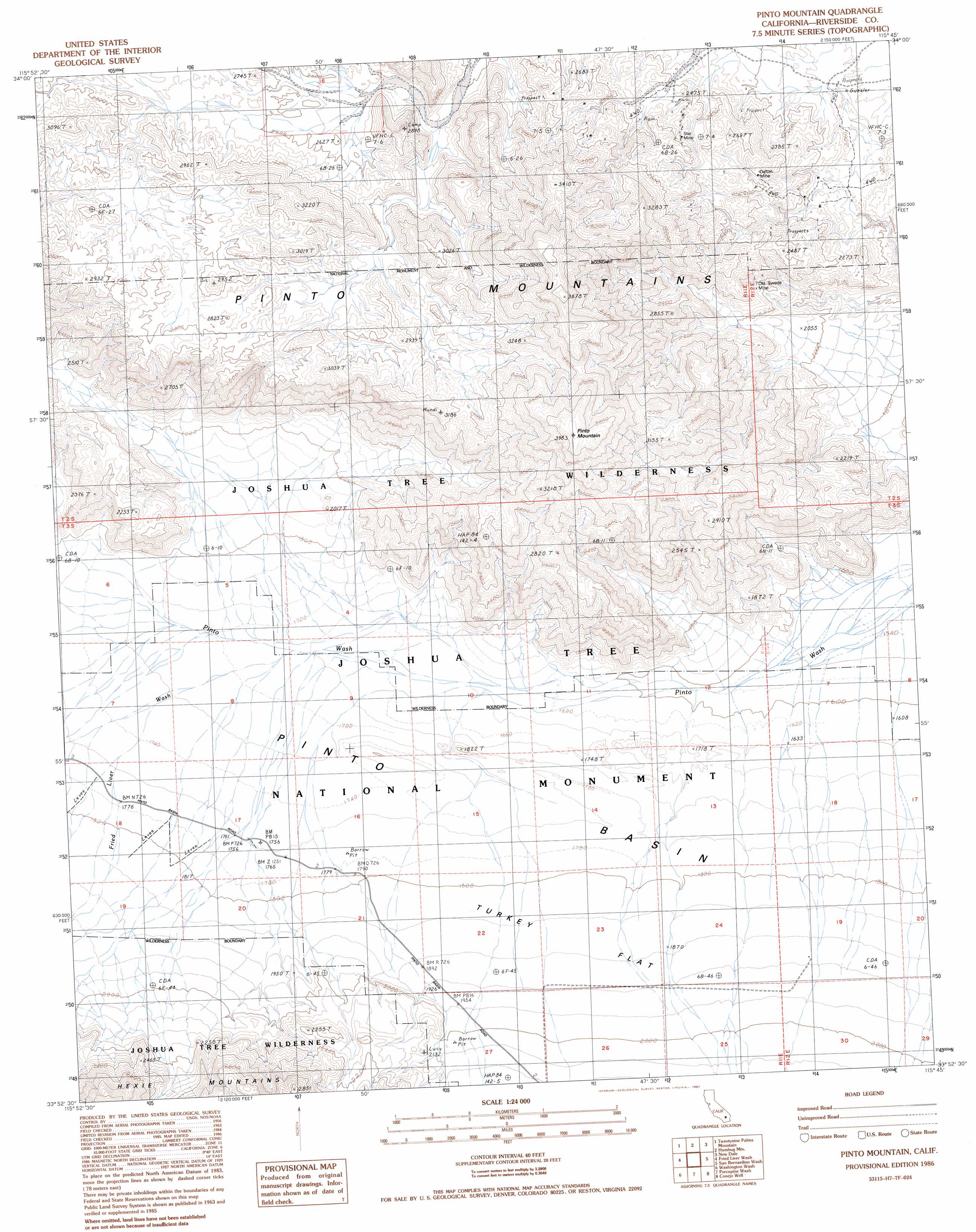
USGS Topo Quad 33115h7 - 1:24,000 scale
| Topo Map Name: | Pinto Mountain |
| USGS Topo Quad ID: | 33115h7 |
| Print Size: | ca. 21 1/4" wide x 27" high |
| Southeast Coordinates: | 33.875° N latitude / 115.75° W longitude |
| Map Center Coordinates: | 33.9375° N latitude / 115.8125° W longitude |
| U.S. State: | CA |
| Filename: | o33115h7.jpg |
| Download Map JPG Image: | Pinto Mountain topo map 1:24,000 scale |
| Map Type: | Topographic |
| Topo Series: | 7.5´ |
| Map Scale: | 1:24,000 |
| Source of Map Images: | United States Geological Survey (USGS) |
| Alternate Map Versions: |
Pinto Mountain CA 1986, updated 1987 Download PDF Buy paper map Pinto Mountain CA 2012 Download PDF Buy paper map Pinto Mountain CA 2015 Download PDF Buy paper map |
1:24,000 Topo Quads surrounding Pinto Mountain
Twentynine Palms |
Valley Mountain |
East Of Valley Mountain |
Dale Lake |
East Of Dale Lake |
Queen Mountain |
Twentynine Palms Mountain |
Humbug Mountain |
New Dale |
Clarks Pass |
Malapai Hill |
Fried Liver Wash |
Pinto Mountain |
San Bernardino Wash |
Placer Canyon |
Rockhouse Canyon |
Washington Wash |
Porcupine Wash |
Conejo Well |
Buzzard Spring |
Thermal Canyon |
Cottonwood Basin |
Cottonwood Spring |
Hayfield |
Hayfield Spring |
> Back to 33115e1 at 1:100,000 scale
> Back to 33114a1 at 1:250,000 scale
> Back to U.S. Topo Maps home
Pinto Mountain topo map: Gazetteer
Pinto Mountain: Flats
Turkey Flat elevation 569m 1866′Pinto Mountain: Mines
Dalton Mine elevation 722m 2368′Old Swede Mine elevation 694m 2276′
Star Mine elevation 768m 2519′
Pinto Mountain: Streams
Fried Liver Wash elevation 514m 1686′Pinto Mountain: Summits
Pinto Mountain elevation 1173m 3848′Pinto Mountain digital topo map on disk
Buy this Pinto Mountain topo map showing relief, roads, GPS coordinates and other geographical features, as a high-resolution digital map file on DVD: