Rodriguez Mountain Topo Map California
To zoom in, hover over the map of Rodriguez Mountain
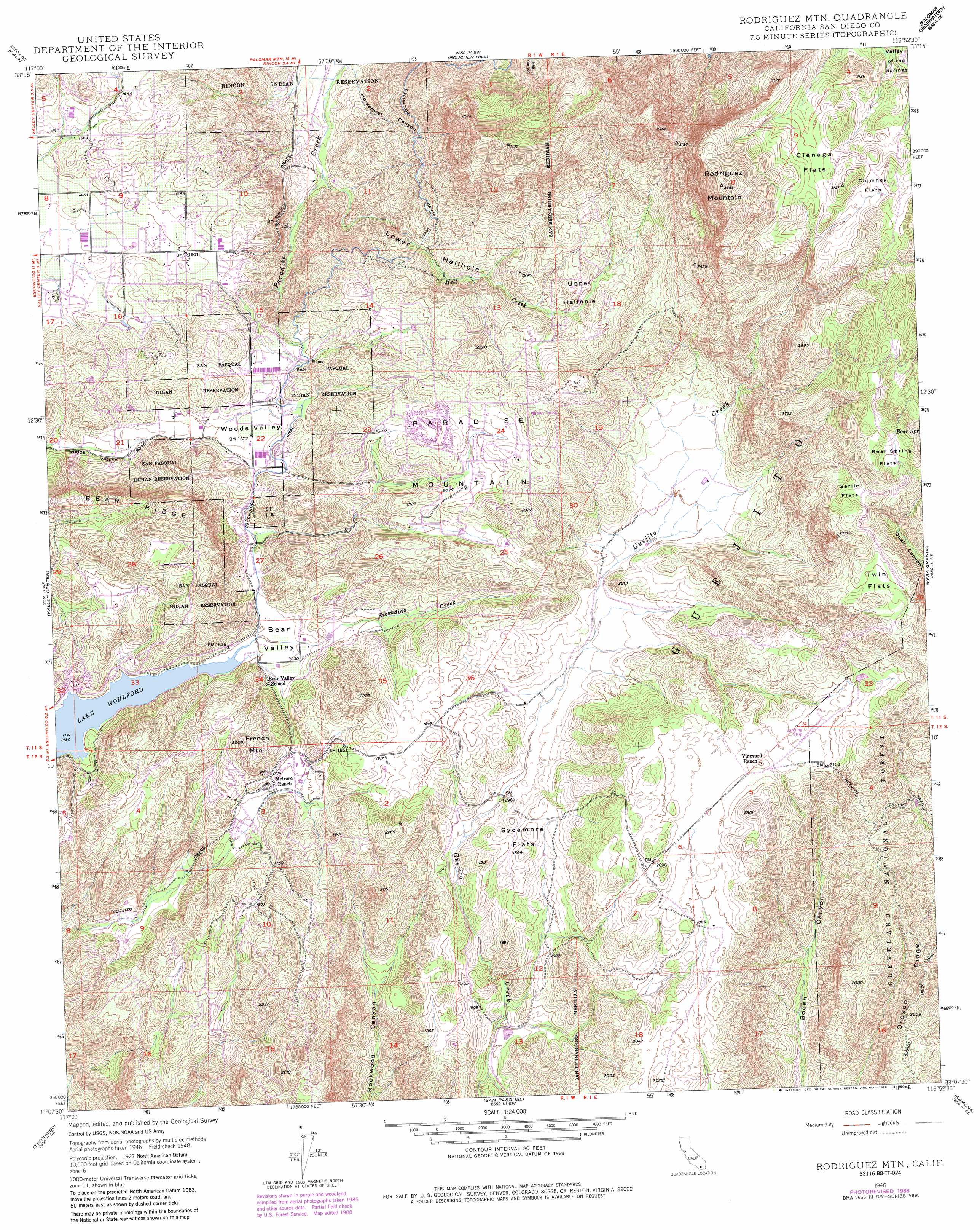
USGS Topo Quad 33116b8 - 1:24,000 scale
| Topo Map Name: | Rodriguez Mountain |
| USGS Topo Quad ID: | 33116b8 |
| Print Size: | ca. 21 1/4" wide x 27" high |
| Southeast Coordinates: | 33.125° N latitude / 116.875° W longitude |
| Map Center Coordinates: | 33.1875° N latitude / 116.9375° W longitude |
| U.S. State: | CA |
| Filename: | o33116b8.jpg |
| Download Map JPG Image: | Rodriguez Mountain topo map 1:24,000 scale |
| Map Type: | Topographic |
| Topo Series: | 7.5´ |
| Map Scale: | 1:24,000 |
| Source of Map Images: | United States Geological Survey (USGS) |
| Alternate Map Versions: |
Rodriguez Mtn. CA 1948, updated 1957 Download PDF Buy paper map Rodriguez Mtn. CA 1948, updated 1964 Download PDF Buy paper map Rodriguez Mtn. CA 1948, updated 1973 Download PDF Buy paper map Rodriguez Mtn CA 1948, updated 1979 Download PDF Buy paper map Rodriguez Mtn. CA 1948, updated 1984 Download PDF Buy paper map Rodriguez Mtn. CA 1948, updated 1988 Download PDF Buy paper map Rodriguez Mtn. CA 1949 Download PDF Buy paper map Rodriguez Mountain CA 1997, updated 2000 Download PDF Buy paper map Rodriguez Mountain CA 2012 Download PDF Buy paper map Rodriguez Mountain CA 2015 Download PDF Buy paper map |
| FStopo: | US Forest Service topo Rodriguez Mountain is available: Download FStopo PDF Download FStopo TIF |
1:24,000 Topo Quads surrounding Rodriguez Mountain
Temecula |
Pechanga |
Vail Lake |
Aguanga |
Beauty Mountain |
Bonsall |
Pala |
Boucher Hill |
Palomar Observatory |
Warner Springs |
San Marcos |
Valley Center |
Rodriguez Mountain |
Mesa Grande |
Warners Ranch |
Rancho Santa Fe |
Escondido |
San Pasqual |
Ramona |
Santa Ysabel |
Del Mar |
Poway |
San Vicente Reservoir |
El Cajon Mountain |
Tule Springs |
> Back to 33116a1 at 1:100,000 scale
> Back to 33116a1 at 1:250,000 scale
> Back to U.S. Topo Maps home
Rodriguez Mountain topo map: Gazetteer
Rodriguez Mountain: Canals
Escondido Canal elevation 541m 1774′Rodriguez Mountain: Flats
Bear Spring Flats elevation 883m 2896′Chimney Flats elevation 910m 2985′
Cienaga Flats elevation 920m 3018′
Garlic Flats elevation 813m 2667′
Sycamore Flats elevation 548m 1797′
Twin Flats elevation 789m 2588′
Rodriguez Mountain: Parks
Hellhole Canyon County Open Space Preserve elevation 624m 2047′Rodriguez Mountain: Springs
Bear Spring elevation 903m 2962′Rodriguez Mountain: Streams
Hell Creek elevation 297m 974′Rodriguez Mountain: Summits
French Mountain elevation 609m 1998′Paradise Mountain elevation 710m 2329′
Rodriguez Mountain elevation 1183m 3881′
Rodriguez Mountain: Valleys
Bear Valley elevation 453m 1486′Horsethief Canyon elevation 287m 941′
Lower Hellhole elevation 297m 974′
Upper Hellhole elevation 501m 1643′
Rodriguez Mountain digital topo map on disk
Buy this Rodriguez Mountain topo map showing relief, roads, GPS coordinates and other geographical features, as a high-resolution digital map file on DVD: