Palomar Observatory Topo Map California
To zoom in, hover over the map of Palomar Observatory
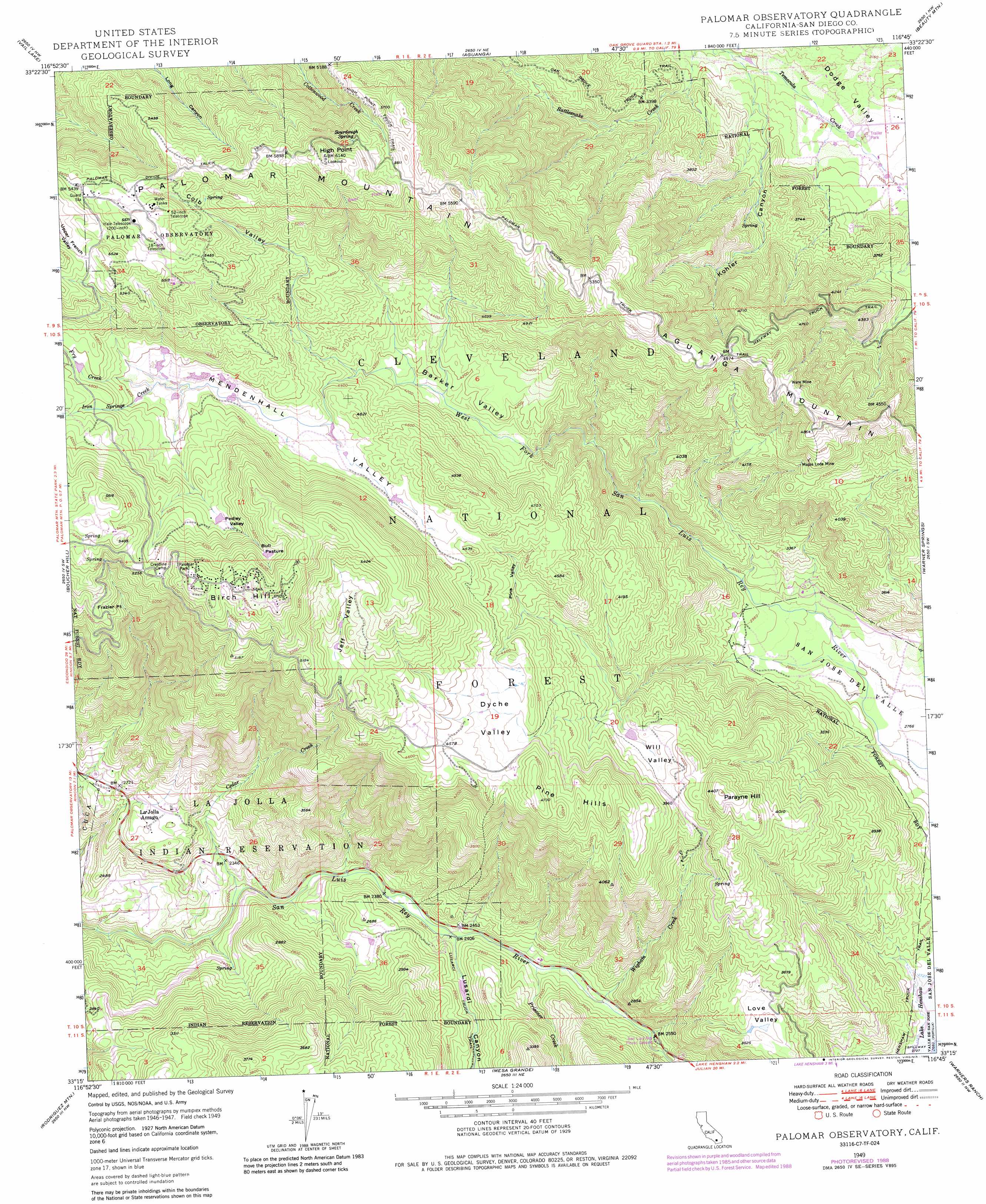
USGS Topo Quad 33116c7 - 1:24,000 scale
| Topo Map Name: | Palomar Observatory |
| USGS Topo Quad ID: | 33116c7 |
| Print Size: | ca. 21 1/4" wide x 27" high |
| Southeast Coordinates: | 33.25° N latitude / 116.75° W longitude |
| Map Center Coordinates: | 33.3125° N latitude / 116.8125° W longitude |
| U.S. State: | CA |
| Filename: | o33116c7.jpg |
| Download Map JPG Image: | Palomar Observatory topo map 1:24,000 scale |
| Map Type: | Topographic |
| Topo Series: | 7.5´ |
| Map Scale: | 1:24,000 |
| Source of Map Images: | United States Geological Survey (USGS) |
| Alternate Map Versions: |
Palomar Observatory CA 1949, updated 1955 Download PDF Buy paper map Palomar Observatory CA 1949, updated 1968 Download PDF Buy paper map Palomar Observatory CA 1949, updated 1973 Download PDF Buy paper map Palomar Observatory CA 1949, updated 1984 Download PDF Buy paper map Palomar Observatory CA 1949, updated 1988 Download PDF Buy paper map Palomar Observatory CA 1950 Download PDF Buy paper map Palomar Observatory CA 1950 Download PDF Buy paper map Palomar Observatory CA 1997, updated 2000 Download PDF Buy paper map Palomar Observatory CA 2012 Download PDF Buy paper map Palomar Observatory CA 2015 Download PDF Buy paper map |
| FStopo: | US Forest Service topo Palomar Observatory is available: Download FStopo PDF Download FStopo TIF |
1:24,000 Topo Quads surrounding Palomar Observatory
Bachelor Mountain |
Sage |
Cahuilla Mountain |
Anza |
Butterfly Peak |
Pechanga |
Vail Lake |
Aguanga |
Beauty Mountain |
Bucksnort Mountain |
Pala |
Boucher Hill |
Palomar Observatory |
Warner Springs |
Hot Springs Mountain |
Valley Center |
Rodriguez Mountain |
Mesa Grande |
Warners Ranch |
Ranchita |
Escondido |
San Pasqual |
Ramona |
Santa Ysabel |
Julian |
> Back to 33116a1 at 1:100,000 scale
> Back to 33116a1 at 1:250,000 scale
> Back to U.S. Topo Maps home
Palomar Observatory topo map: Gazetteer
Palomar Observatory: Basins
Love Valley elevation 1044m 3425′Mendenhall Valley elevation 1353m 4438′
Palomar Observatory: Capes
Frazier Point elevation 1492m 4895′Palomar Observatory: Flats
Bull Pasture elevation 1609m 5278′Palomar Park elevation 1659m 5442′
Palomar Observatory: Forests
Cleveland National Forest elevation 1190m 3904′Palomar Observatory: Mines
Maple Lode Mine elevation 1353m 4438′Ware Mine elevation 1470m 4822′
Palomar Observatory: Populated Places
La Jolla Amago elevation 850m 2788′Palomar Observatory: Ranges
Pine Hills elevation 1408m 4619′Palomar Observatory: Ridges
Palomar Mountain elevation 1870m 6135′Palomar Observatory: Springs
Sourdough Spring elevation 1755m 5757′Palomar Observatory: Streams
Cedar Creek elevation 660m 2165′Fry Creek elevation 1381m 4530′
Iron Springs Creek elevation 1381m 4530′
Prisoner Creek elevation 748m 2454′
Wigham Creek elevation 757m 2483′
Palomar Observatory: Summits
Aguanga Mountain elevation 1577m 5173′Birch Hill elevation 1737m 5698′
High Point elevation 1851m 6072′
Parayne Hill elevation 1342m 4402′
Palomar Observatory: Trails
Barker Valley Spur elevation 1552m 5091′Barker Valley Trail elevation 1390m 4560′
Halfway Truck Trail elevation 1362m 4468′
Henshaw Truck Trail elevation 840m 2755′
Oak Grove Truck Trail elevation 1028m 3372′
Palomar Divide Truck Trail elevation 1755m 5757′
Palomar Observatory: Valleys
Barker Valley elevation 1217m 3992′Colb Valley elevation 1303m 4274′
Dyche Valley elevation 1340m 4396′
Jeff Valley elevation 1498m 4914′
Kohler Canyon elevation 940m 3083′
Lusardi Canyon elevation 733m 2404′
Pedley Valley elevation 1488m 4881′
Pine Valley elevation 1273m 4176′
Will Valley elevation 1142m 3746′
Palomar Observatory digital topo map on disk
Buy this Palomar Observatory topo map showing relief, roads, GPS coordinates and other geographical features, as a high-resolution digital map file on DVD: