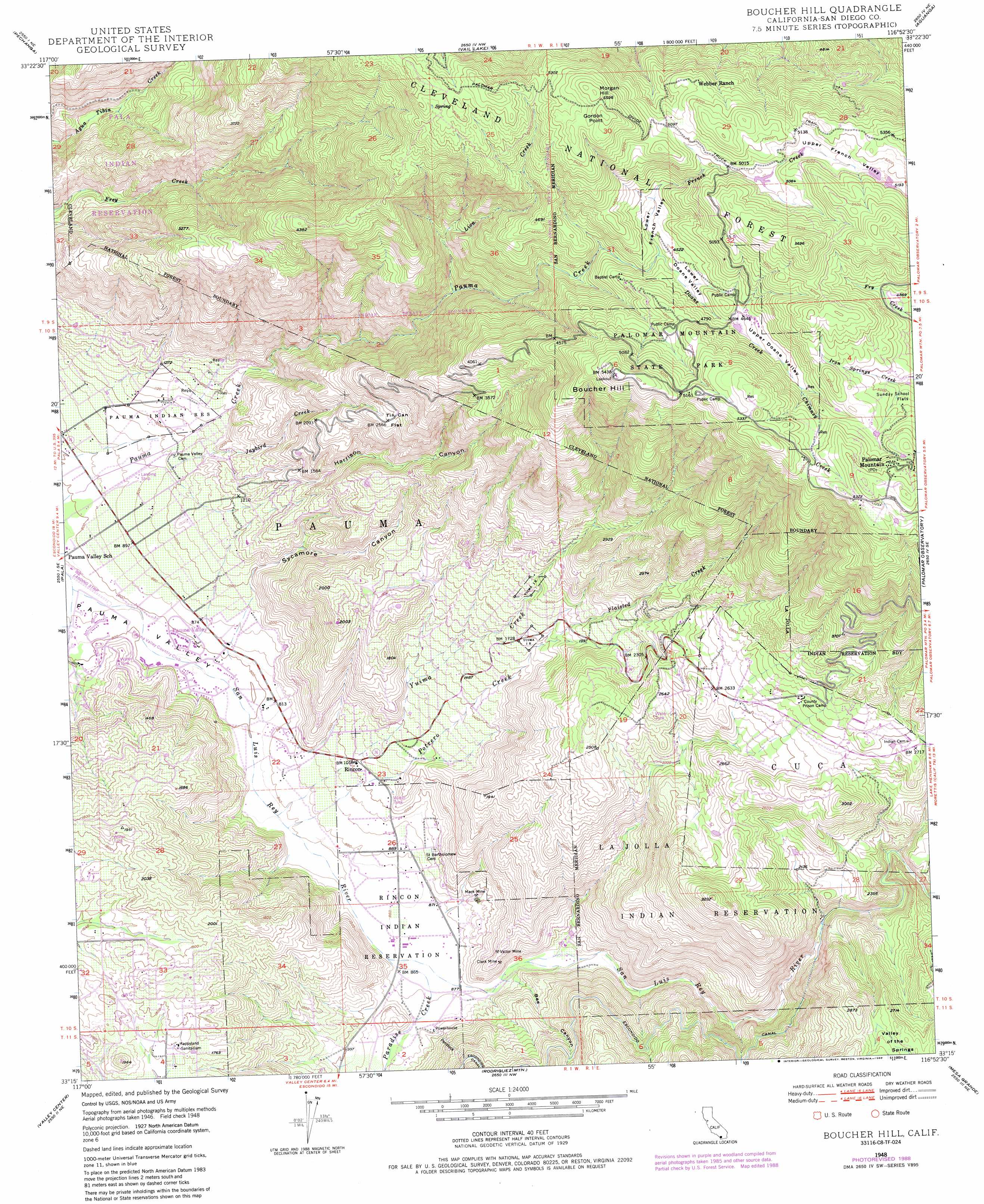
Boucher Hill Topo Map California
To zoom in, hover over the map of Boucher Hill
USGS Topo Quad 33116c8 - 1:24,000 scale
| Topo Map Name: | Boucher Hill |
| USGS Topo Quad ID: | 33116c8 |
| Print Size: | ca. 21 1/4" wide x 27" high |
| Southeast Coordinates: | 33.25° N latitude / 116.875° W longitude |
| Map Center Coordinates: | 33.3125° N latitude / 116.9375° W longitude |
| U.S. State: | CA |
| Filename: | o33116c8.jpg |
| Download Map JPG Image: | Boucher Hill topo map 1:24,000 scale |
| Map Type: | Topographic |
| Topo Series: | 7.5´ |
| Map Scale: | 1:24,000 |
| Source of Map Images: | United States Geological Survey (USGS) |
| Alternate Map Versions: |
Boucher Hill CA 1948, updated 1958 Download PDF Buy paper map Boucher Hill CA 1948, updated 1966 Download PDF Buy paper map Boucher Hill CA 1948, updated 1973 Download PDF Buy paper map Boucher Hill CA 1948, updated 1973 Download PDF Buy paper map Boucher Hill CA 1948, updated 1980 Download PDF Buy paper map Boucher Hill CA 1948, updated 1984 Download PDF Buy paper map Boucher Hill CA 1948, updated 1988 Download PDF Buy paper map Boucher Hill CA 1950 Download PDF Buy paper map Boucher Hill CA 1950 Download PDF Buy paper map Boucher Hill CA 1997, updated 2000 Download PDF Buy paper map Boucher Hill CA 2012 Download PDF Buy paper map Boucher Hill CA 2015 Download PDF Buy paper map |
| FStopo: | US Forest Service topo Boucher Hill is available: Download FStopo PDF Download FStopo TIF |
1:24,000 Topo Quads surrounding Boucher Hill
Murrieta |
Bachelor Mountain |
Sage |
Cahuilla Mountain |
Anza |
Temecula |
Pechanga |
Vail Lake |
Aguanga |
Beauty Mountain |
Bonsall |
Pala |
Boucher Hill |
Palomar Observatory |
Warner Springs |
San Marcos |
Valley Center |
Rodriguez Mountain |
Mesa Grande |
Warners Ranch |
Rancho Santa Fe |
Escondido |
San Pasqual |
Ramona |
Santa Ysabel |
> Back to 33116a1 at 1:100,000 scale
> Back to 33116a1 at 1:250,000 scale
> Back to U.S. Topo Maps home
Boucher Hill topo map: Gazetteer
Boucher Hill: Airports
Lyall-Roberts Airport elevation 271m 889′Pauma Valley Air Park elevation 229m 751′
Boucher Hill: Flats
Chimney Flats elevation 1558m 5111′Sunday School Flats elevation 1521m 4990′
Tin Can Flat elevation 790m 2591′
Boucher Hill: Mines
Clark Mine elevation 331m 1085′Mack Mine elevation 293m 961′
Victor Mine elevation 397m 1302′
Boucher Hill: Parks
Doane Valley Natural Preserve elevation 1373m 4504′Palomar Mountain State Park elevation 1485m 4872′
Boucher Hill: Populated Places
Palomar Mountain elevation 1623m 5324′Pauma Valley elevation 246m 807′
Rincon elevation 314m 1030′
Boucher Hill: Post Offices
Pauma Valley Post Office elevation 254m 833′Boucher Hill: Reservoirs
Doane Pond elevation 1419m 4655′Doane Valley Reservoir elevation 1529m 5016′
Boucher Hill: Streams
Doane Creek elevation 1361m 4465′French Creek elevation 1361m 4465′
Jaybird Creek elevation 294m 964′
Lion Creek elevation 903m 2962′
Paradise Creek elevation 262m 859′
Plaisted Creek elevation 568m 1863′
Potrero Creek elevation 254m 833′
Yuima Creek elevation 253m 830′
Boucher Hill: Summits
Boucher Hill elevation 1651m 5416′Gordon Point elevation 1722m 5649′
Lone Fir Point elevation 1463m 4799′
Morgan Hill elevation 1718m 5636′
Boucher Hill: Trails
Adams Trail elevation 1490m 4888′Baptist Trail elevation 1457m 4780′
Boucher Trail elevation 1608m 5275′
Cedar Trail elevation 1472m 4829′
Doane Valley Nature Trail elevation 1391m 4563′
French Valley Trail elevation 1391m 4563′
Fry Creek Trail elevation 1556m 5104′
Gomez Trail elevation 1507m 4944′
Lower Doane Trail elevation 1389m 4557′
Mission Trail elevation 1185m 3887′
Scotts Cabin Trail elevation 1629m 5344′
Thunder Spring Trail elevation 1475m 4839′
Upper Doane Valley Trail elevation 1446m 4744′
Weir Trail elevation 1388m 4553′
Boucher Hill: Valleys
Bee Canyon elevation 276m 905′Doane Valley elevation 1355m 4445′
Harrison Canyon elevation 290m 951′
Lower Doane Valley elevation 1359m 4458′
Lower French Valley elevation 1361m 4465′
Sycamore Canyon elevation 304m 997′
Upper Doane Valley elevation 1424m 4671′
Upper French Valley elevation 1563m 5127′
Valley of the Springs elevation 798m 2618′
Boucher Hill digital topo map on disk
Buy this Boucher Hill topo map showing relief, roads, GPS coordinates and other geographical features, as a high-resolution digital map file on DVD: