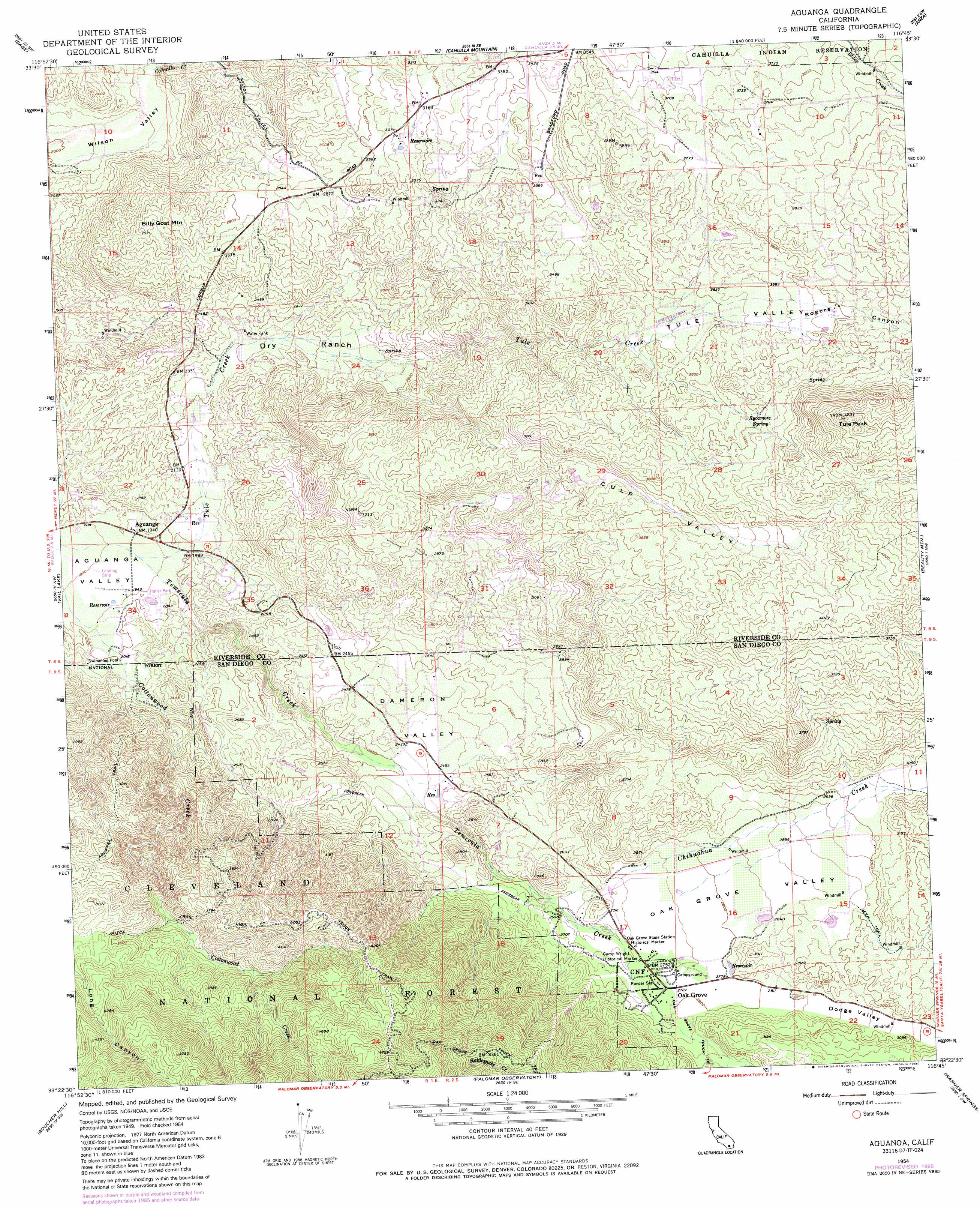
Aguanga Topo Map California
To zoom in, hover over the map of Aguanga
USGS Topo Quad 33116d7 - 1:24,000 scale
| Topo Map Name: | Aguanga |
| USGS Topo Quad ID: | 33116d7 |
| Print Size: | ca. 21 1/4" wide x 27" high |
| Southeast Coordinates: | 33.375° N latitude / 116.75° W longitude |
| Map Center Coordinates: | 33.4375° N latitude / 116.8125° W longitude |
| U.S. State: | CA |
| Filename: | o33116d7.jpg |
| Download Map JPG Image: | Aguanga topo map 1:24,000 scale |
| Map Type: | Topographic |
| Topo Series: | 7.5´ |
| Map Scale: | 1:24,000 |
| Source of Map Images: | United States Geological Survey (USGS) |
| Alternate Map Versions: |
Aguanga CA 1954, updated 1955 Download PDF Buy paper map Aguanga CA 1954, updated 1961 Download PDF Buy paper map Aguanga CA 1954, updated 1972 Download PDF Buy paper map Aguanga CA 1954, updated 1972 Download PDF Buy paper map Aguanga CA 1954, updated 1972 Download PDF Buy paper map Aguanga CA 1954, updated 1980 Download PDF Buy paper map Aguanga CA 1954, updated 1985 Download PDF Buy paper map Aguanga CA 1954, updated 1988 Download PDF Buy paper map Aguanga CA 1954, updated 1988 Download PDF Buy paper map Aguanga CA 1997, updated 2000 Download PDF Buy paper map Aguanga CA 2012 Download PDF Buy paper map Aguanga CA 2015 Download PDF Buy paper map |
| FStopo: | US Forest Service topo Aguanga is available: Download FStopo PDF Download FStopo TIF |
1:24,000 Topo Quads surrounding Aguanga
Winchester |
Hemet |
Blackburn Canyon |
Idyllwild |
Palm View Peak |
Bachelor Mountain |
Sage |
Cahuilla Mountain |
Anza |
Butterfly Peak |
Pechanga |
Vail Lake |
Aguanga |
Beauty Mountain |
Bucksnort Mountain |
Pala |
Boucher Hill |
Palomar Observatory |
Warner Springs |
Hot Springs Mountain |
Valley Center |
Rodriguez Mountain |
Mesa Grande |
Warners Ranch |
Ranchita |
> Back to 33116a1 at 1:100,000 scale
> Back to 33116a1 at 1:250,000 scale
> Back to U.S. Topo Maps home
Aguanga topo map: Gazetteer
Aguanga: Airports
Ward Ranch Airport elevation 740m 2427′Aguanga: Parks
Camp Wright Historical Marker elevation 833m 2732′Oak Grove Stage Station Historical Marker elevation 830m 2723′
Aguanga: Populated Places
Aguanga elevation 596m 1955′Oak Grove elevation 849m 2785′
Aguanga: Springs
Sycamore Spring elevation 1163m 3815′Aguanga: Streams
Cahuilla Creek elevation 642m 2106′Chihuahua Creek elevation 790m 2591′
Rattlesnake Creek elevation 885m 2903′
Tule Creek elevation 593m 1945′
Aguanga: Summits
Billy Goat Mountain elevation 893m 2929′Tule Peak elevation 1468m 4816′
Aguanga: Trails
Aguanga Trail elevation 1005m 3297′Cutca Trail elevation 1030m 3379′
High Point Truck Trail elevation 1259m 4130′
Aguanga: Valleys
Cahuilla Valley elevation 1102m 3615′Culp Valley elevation 885m 2903′
Dameron Valley elevation 692m 2270′
Dodge Valley elevation 850m 2788′
Oak Grove Valley elevation 831m 2726′
Rogers Canyon elevation 1056m 3464′
Tule Valley elevation 1054m 3458′
Aguanga digital topo map on disk
Buy this Aguanga topo map showing relief, roads, GPS coordinates and other geographical features, as a high-resolution digital map file on DVD: