Indio Topo Map California
To zoom in, hover over the map of Indio
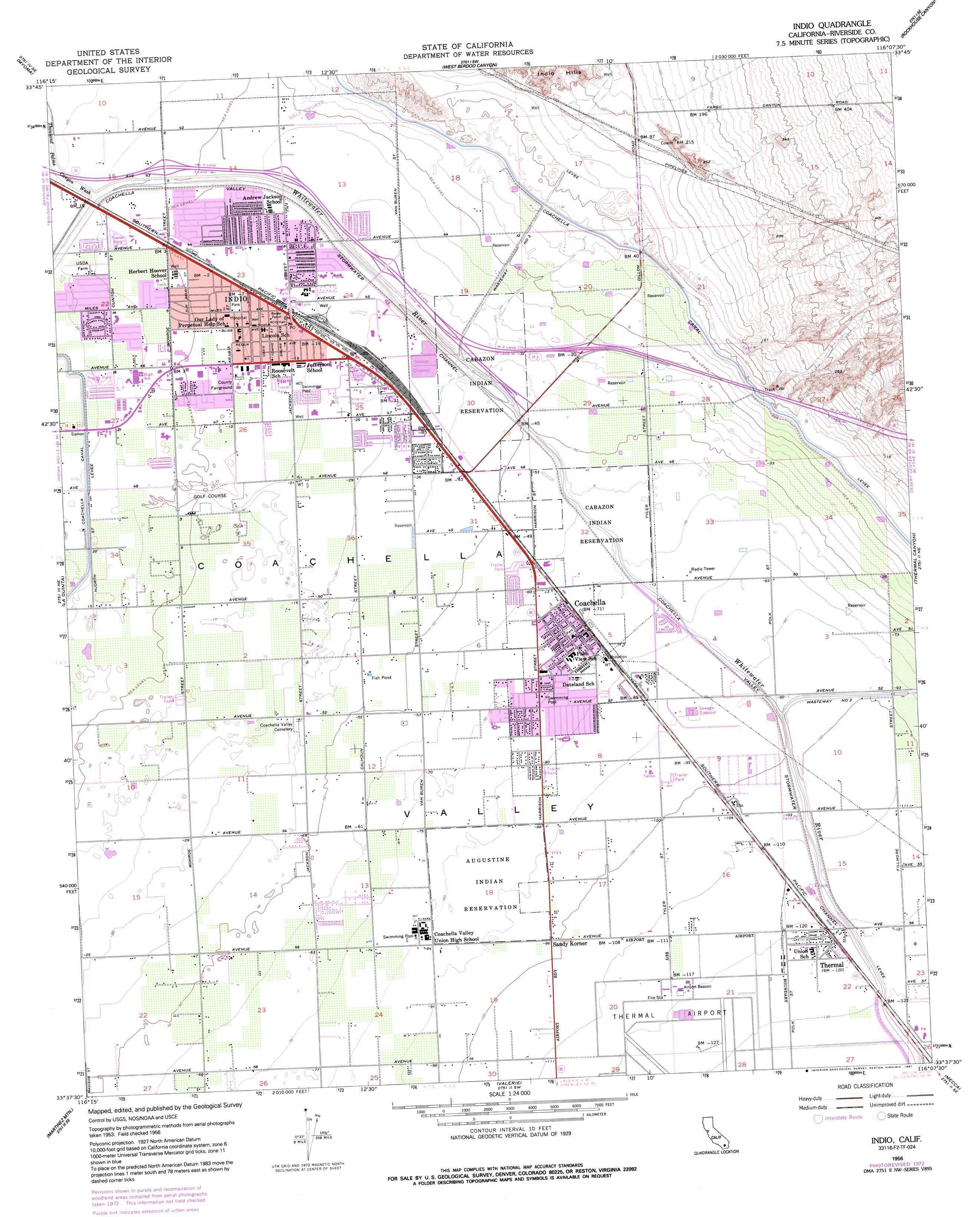
USGS Topo Quad 33116f2 - 1:24,000 scale
| Topo Map Name: | Indio |
| USGS Topo Quad ID: | 33116f2 |
| Print Size: | ca. 21 1/4" wide x 27" high |
| Southeast Coordinates: | 33.625° N latitude / 116.125° W longitude |
| Map Center Coordinates: | 33.6875° N latitude / 116.1875° W longitude |
| U.S. State: | CA |
| Filename: | o33116f2.jpg |
| Download Map JPG Image: | Indio topo map 1:24,000 scale |
| Map Type: | Topographic |
| Topo Series: | 7.5´ |
| Map Scale: | 1:24,000 |
| Source of Map Images: | United States Geological Survey (USGS) |
| Alternate Map Versions: |
Indio CA 1956, updated 1957 Download PDF Buy paper map Indio CA 1956, updated 1963 Download PDF Buy paper map Indio CA 1956, updated 1973 Download PDF Buy paper map Indio CA 1956, updated 1991 Download PDF Buy paper map Indio CA 1975, updated 1977 Download PDF Buy paper map Indio CA 2012 Download PDF Buy paper map Indio CA 2015 Download PDF Buy paper map |
1:24,000 Topo Quads surrounding Indio
Seven Palms Valley |
East Deception Canyon |
Keys View |
Malapai Hill |
Fried Liver Wash |
Cathedral City |
Myoma |
West Berdoo Canyon |
Rockhouse Canyon |
Washington Wash |
Rancho Mirage |
La Quinta |
Indio |
Thermal Canyon |
Cottonwood Basin |
Toro Peak |
Martinez Mountain |
Valerie |
Mecca |
Mortmar |
Collins Valley |
Clark Lake Ne |
Rabbit Peak |
Oasis |
Salton |
> Back to 33116e1 at 1:100,000 scale
> Back to 33116a1 at 1:250,000 scale
> Back to U.S. Topo Maps home
Indio topo map: Gazetteer
Indio: Airports
John F Kennedy Memorial Hospital Heliport elevation 3m 9′Thermal Airport elevation -38m -125′
Indio: Canals
Coachella Valley Stormwater Channel elevation -32m -105′Wasteway Number Three elevation 1m 3′
Wasteway Number Two elevation -30m -99′
Indio: Dams
East Side Detention Dike Number 2 Dam elevation 41m 134′Indio: Parks
Bagdouma Park elevation -21m -69′Carreon Park elevation 2m 6′
Dateland Park elevation -23m -76′
Davis Sports Complex elevation -7m -23′
De Oro Park elevation -16m -53′
Desert Park elevation 8m 26′
Indio Terrace Park elevation -6m -20′
Miles Park elevation -2m -7′
North Jackson Park elevation -4m -14′
Riverside County Fairgrounds elevation -3m -10′
Sierra Vista Park elevation -23m -76′
South Jackson Park elevation -5m -17′
Thermal Ball Park elevation -37m -122′
Indio: Populated Places
Arabian Gardens Mobile Home Park elevation 3m 9′Coachella elevation -21m -69′
Coronado Gardens Mobile Home Park elevation 3m 9′
Desert Groves Mobile Home Park elevation 2m 6′
Indio elevation -4m -14′
Pueblo del Sol Mobile Park elevation 6m 19′
Rancho Casitas Mobile Home Park elevation 8m 26′
Sandy Korner elevation -29m -96′
Sunnyside Estates elevation 9m 29′
Thermal elevation -36m -119′
Vista Santa Rosa elevation -21m -69′
Indio: Post Offices
Coachella Post Office elevation -21m -69′Indio Post Office elevation -4m -14′
Indio: Streams
Thousand Palm Canyon Wash elevation 4m 13′Indio digital topo map on disk
Buy this Indio topo map showing relief, roads, GPS coordinates and other geographical features, as a high-resolution digital map file on DVD: